TopoQuest Logo
Do you find TopoQuest useful?
Help keep TopoQuest running and adding new maps/features by donating!
Bitcoin:  19c7KJd3qBynnjoSw5npx9KScwjBe4ifkT
Litecoin:  LXs6TkuXGGXo1vDsWCkWVdjQX94eUKd6ui
Home View Maps Find Maps Find Places Resources & Links


Utica, Montana Topographic Map

USGS Map Title: Utica, MT
USGS Map MRC: 46110H1
DRG (GeoTIFF) Download: o46110h1.tif


Neighboring USGS Topographic Map Quads:


  Windham, MT  
47110A2
 

  Benchland, MT  
47110A1
 

  Moccasin, MT  
47109A8
 

  Red Hill, MT  
46110H2
 

  Utica, MT  
46110H1
 

  Ackley Lake, MT  
46109H8
 

  Browns Canyon, MT  
46110G2
 

  Twin Sisters, MT  
46110G1
 

  Martin Coulee, MT  
46109G8


Map MRC Location:

N47°
W111°
N47°
W110°
H8 H7 H6 H5 H4 H3 H2 H1
G8 G7 G6 G5 G4 G3 G2 G1
F8 F7 F6 F5 F4 F3 F2 F1
E8 E7 E6 E5 E4 E3 E2 E1
D8 D7 D6 D5 D4 D3 D2 D1
C8 C7 C6 C5 C4 C3 C2 C1
B8 B7 B6 B5 B4 B3 B2 B1
A8 A7 A6 A5 A4 A3 A2 A1
N46°
W111°
N46°
W110°

Utica, MT USGS 1:24K Topographic Map Preview:
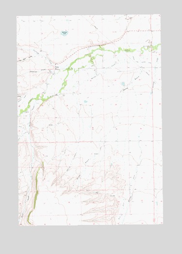
Utica, MT USGS Topographic Map
Click on map above to begin viewing in our Map Viewer.

This topographic map contains these locations and features:
Feature Name Type Latitude Longitude GNIS ID View Map
13N13E03AA__01 WellWellN46.9222°W110.0519°819399View Map
13N13E03AA__02 SpringSpringN46.9222°W110.0519°819400View Map
13N13E04AADD01 WellWellN46.9214°W110.0727°819393View Map
13N13E04BD__01 SpringSpringN46.9186°W110.0833°819370View Map
13N13E04CB__01 SpringSpringN46.9150°W110.0885°819352View Map
13N13E05BD__01 SpringSpringN46.9186°W110.1044°819371View Map
13N13E05CC__01 WellWellN46.9113°W110.1096°819336View Map
13N13E05CD__01 SpringSpringN46.9116°W110.1060°819338View Map
13N13E06AA__01 WellWellN46.9222°W110.1149°819401View Map
13N13E08AB__01 SpringSpringN46.9077°W110.0991°819318View Map
13N13E08BA__01 SpringSpringN46.9077°W110.1044°819319View Map
13N13E08BB__01 WellWellN46.9077°W110.1096°819320View Map
13N13E09CB__01 SpringSpringN46.9005°W110.0885°819266View Map
13N13E10BC__01 SpringSpringN46.9041°W110.0677°819291View Map
13N13E11DD__01 WellWellN46.8969°W110.0308°819245View Map
13N13E12CC__01 WellWellN46.8969°W110.0255°819240View Map
13N13E12CC__02 WellWellN46.8969°W110.0255°819241View Map
13N13E12CC__03 WellWellN46.8969°W110.0255°819242View Map
13N13E12CC__04 WellWellN46.8969°W110.0255°819243View Map
13N13E12CC__05 WellWellN46.8969°W110.0255°819244View Map
13N13E14AB__01 SpringSpringN46.8933°W110.0360°819201View Map
13N13E15AD__01 SpringSpringN46.8897°W110.0519°819154View Map
13N13E15BA__01 SpringSpringN46.8933°W110.0624°819202View Map
13N13E17DC__01 WellWellN46.8825°W110.0991°819066View Map
14N13E11CCD_01 WellWellN46.9833°W110.0458°819932View Map
14N13E15CC__01 WellWellN46.9683°W110.0683°819818View Map
14N13E15CC__02 SpringSpringN46.9683°W110.0683°819819View Map
14N13E15CD__01 SpringSpringN46.9683°W110.0630°819817View Map
14N13E16CC__01 WellWellN46.9680°W110.0913°819813View Map
14N13E16CCCD01 WellWellN46.9683°W110.0919°819820View Map
14N13E19DDC_01 WellWellN46.9541°W110.1194°819647View Map
14N13E21AA__01 WellWellN46.9644°W110.0733°819776View Map
14N13E21BBB_01 WellWellN46.9675°W110.0919°819812View Map
14N13E21DB__01 WellWellN46.9572°W110.0785°819686View Map
14N13E21DC__01 WellWellN46.9536°W110.0785°819637View Map
14N13E22AA__01 SpringSpringN46.9644°W110.0524°819772View Map
14N13E22AA__02 SpringSpringN46.9644°W110.0524°819773View Map
14N13E22AB__01 SpringSpringN46.9644°W110.0577°819774View Map
14N13E22AC__01 WellWellN46.9608°W110.0577°819721View Map
14N13E22BB__01 SpringSpringN46.9644°W110.0683°819775View Map
14N13E23BB__01 WellWellN46.9644°W110.0471°819770View Map
14N13E23BB__02 WellWellN46.9644°W110.0471°819771View Map
14N13E24AB__01 WellWellN46.9644°W110.0155°819767View Map
14N13E24BA__01 WellWellN46.9644°W110.0208°819768View Map
14N13E24BA__02 WellWellN46.9644°W110.0208°819769View Map
14N13E24BCBA01 WellWellN46.9639°W110.0283°819763View Map
14N13E24BD__01 WellWellN46.9608°W110.0208°819720View Map
14N13E24CB__01 SpringSpringN46.9572°W110.0260°819685View Map
14N13E26CD__01 WellWellN46.9391°W110.0419°819512View Map
14N13E26DCBB01 WellWellN46.9425°W110.0391°819532View Map
14N13E27DC__01 WellWellN46.9391°W110.0577°819513View Map
14N13E28DD__01 WellWellN46.9391°W110.0733°819514View Map
14N13E28DD__02 WellWellN46.9391°W110.0733°819515View Map
14N13E30ABB_01 WellWellN46.9522°W110.1224°819614View Map
14N13E32CD__01 SpringSpringN46.9247°W110.1049°819419View Map
14N13E33ABAD01 WellWellN46.9377°W110.0780°819504View Map
14N13E33BB__01 SpringSpringN46.9355°W110.0891°819486View Map
14N13E33DA__01 WellWellN46.9283°W110.0733°819443View Map
14N13E35CACC01 WellWellN46.9294°W110.0441°819447View Map
Antelope CreekStreamN46.9816°W110.0038°779073View Map
Big CouleeValleyN46.8975°W110.0338°768760View Map
Coal Bank CouleeValleyN46.9772°W110.1083°769950View Map
Courtneys CreekStreamN46.9708°W110.0794°770209View Map
Ellis CouleeValleyN46.9305°W110.1171°778799View Map
Heiserman CouleeValleyN46.9669°W110.0958°772315View Map
Red Shed LakeLakeN46.9894°W110.0843°775661View Map
Spring BranchStreamN46.9714°W110.0174°776950View Map
Spring CreekStreamN46.9750°W110.0255°777002View Map
UticaPopulated PlaceN46.9683°W110.0924°777954View Map
Utica CemeteryCemeteryN46.9527°W110.0874°777955View Map
Utica ChurchChurchN46.9680°W110.0924°1750696View Map
Utica MuseumBuildingN46.9683°W110.0924°1750713View Map
Utica Post Office (historical)Post OfficeN46.9683°W110.0924°1750592View Map
Utica School (historical)SchoolN46.9650°W110.0944°1750671View Map
Waite CreekStreamN46.9497°W110.1094°792753View Map
West Fork Antelope CreekStreamN46.8941°W110.0291°792974View Map

Note: Coordinates in the location and feature list above are referenced to NAD83 datum.


Copyright (C) 2008-2024 Ryan Niemi / Sunset Dynamics ... All Rights Reserved