TopoQuest Logo
Do you find TopoQuest useful?
Help keep TopoQuest running and adding new maps/features by donating!
Bitcoin:  19c7KJd3qBynnjoSw5npx9KScwjBe4ifkT
Litecoin:  LXs6TkuXGGXo1vDsWCkWVdjQX94eUKd6ui
Home View Maps Find Maps Find Places Resources & Links


Blyton, Illinois Topographic Map

USGS Map Title: Blyton, IL
USGS Map MRC: 40090E3
DRG (GeoTIFF) Download: o40090e3.tif


Neighboring USGS Topographic Map Quads:


  Avon, IL  
40090F4
 

  London Mills, IL  
40090F3
 

  Fairview, IL  
40090F2
 

  Bushnell East, IL  
40090E4
 

  Blyton, IL  
40090E3
 

  Fiatt, IL  
40090E2
 

  Adair, IL  
40090D4
 

  Smithfield, IL  
40090D3
 

  Lewistown, IL  
40090D2


Map MRC Location:

N41°
W91°
N41°
W90°
H8 H7 H6 H5 H4 H3 H2 H1
G8 G7 G6 G5 G4 G3 G2 G1
F8 F7 F6 F5 F4 F3 F2 F1
E8 E7 E6 E5 E4 E3 E2 E1
D8 D7 D6 D5 D4 D3 D2 D1
C8 C7 C6 C5 C4 C3 C2 C1
B8 B7 B6 B5 B4 B3 B2 B1
A8 A7 A6 A5 A4 A3 A2 A1
N40°
W91°
N40°
W90°

Blyton, IL USGS 1:24K Topographic Map Preview:
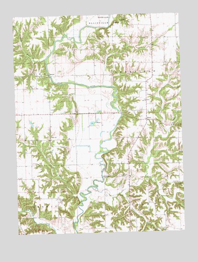
Blyton, IL USGS Topographic Map
Click on map above to begin viewing in our Map Viewer.

This topographic map contains these locations and features:
Feature Name Type Latitude Longitude GNIS ID View Map
Aylesworth BranchStreamN40.6000°W90.3512°403774View Map
BabylonPopulated PlaceN40.5909°W90.3493°422427View Map
Babylon Bend BridgeBridgeN40.5900°W90.3479°1802153View Map
Babylon School (historical)SchoolN40.5889°W90.3585°1719430View Map
Baughman School (historical)SchoolN40.5020°W90.3012°1719432View Map
Big HollowValleyN40.5153°W90.3725°1802154View Map
Blout Centennial FarmLocaleN40.5900°W90.3279°1802201View Map
BlytonPopulated PlaceN40.5642°W90.2765°422482View Map
Blyton Post Office (historical)Post OfficeN40.5664°W90.2768°1802156View Map
BuckeyePopulated PlaceN40.5320°W90.2910°1802204View Map
Buckeye Bridge (historical)BridgeN40.5317°W90.3107°424685View Map
Buckeye CemeteryCemeteryN40.5325°W90.2950°1773314View Map
Buckeye ChurchChurchN40.5323°W90.2948°405114View Map
Buckeye School (historical)SchoolN40.5323°W90.2957°1719436View Map
Clyde Darst PondReservoirN40.5182°W90.3430°1691218View Map
Clyde Darst Pond DamDamN40.5184°W90.3435°1691217View Map
Franklin School (historical)SchoolN40.6114°W90.2682°1719449View Map
Henderson CemeteryCemeteryN40.5275°W90.2532°1773331View Map
Henderson School (historical)SchoolN40.5278°W90.2529°1719458View Map
Laswell BranchStreamN40.5223°W90.2979°424185View Map
Lost Grove CreekStreamN40.5575°W90.2607°412654View Map
Mount Pisgah County ParkParkN40.6206°W90.2971°414040View Map
Mount Pleasant School (historical)SchoolN40.6037°W90.3151°1719473View Map
Pleasant Valley School (historical)SchoolN40.5689°W90.3279°1719486View Map
Put CreekStreamN40.5262°W90.3185°416294View Map
Rigdon CemeteryCemeteryN40.5556°W90.3487°416666View Map
Shoal CreekStreamN40.5187°W90.3268°418442View Map
Shoofly School (historical)SchoolN40.5137°W90.3446°1719498View Map
Sinnett ChapelChurchN40.5275°W90.2535°418546View Map
Sinnett Chapel CemeteryCemeteryN40.5275°W90.2537°1773366View Map
Sweeney School (historical)SchoolN40.5689°W90.3493°1719506View Map
Sweeneys PondReservoirN40.5635°W90.3631°1691206View Map
Sweeneys Pond DamDamN40.5600°W90.3635°1691205View Map
Templars Hall (historical)BuildingN40.5687°W90.3679°1719508View Map
Township of DeerfieldCivilN40.5805°W90.2702°428880View Map
Turkey CreekStreamN40.5314°W90.2785°419925View Map
Victory School (historical)SchoolN40.5542°W90.2843°1719510View Map
Whiteoak Grove School (historical)SchoolN40.5070°W90.2640°1719513View Map
Whites Ferry (historical)CrossingN40.5317°W90.3110°1802249View Map
Wiley CemeteryCemeteryN40.5756°W90.2760°1773376View Map
Wiley Evangelical Lutheran ChurchChurchN40.5756°W90.2765°421168View Map
Wiley School (historical)SchoolN40.5823°W90.2768°1719514View Map
Williams School (historical)SchoolN40.5320°W90.3596°1719515View Map
Ziltz BridgeBridgeN40.5678°W90.2954°1719516View Map

Note: Coordinates in the location and feature list above are referenced to NAD83 datum.


Copyright (C) 2008-2024 Ryan Niemi / Sunset Dynamics ... All Rights Reserved