TopoQuest Logo
Do you find TopoQuest useful?
Help keep TopoQuest running and adding new maps/features by donating!
Bitcoin:  19c7KJd3qBynnjoSw5npx9KScwjBe4ifkT
Litecoin:  LXs6TkuXGGXo1vDsWCkWVdjQX94eUKd6ui
Home View Maps Find Maps Find Places Resources & Links


Tunnel Hill, Georgia Topographic Map

USGS Map Title: Tunnel Hill, GA
USGS Map MRC: 34085G1
DRG (GeoTIFF) Download: o34085g1.tif


Neighboring USGS Topographic Map Quads:


  East Ridge, TN  
34085H2
 

  Ringgold, GA  
34085H1
 

  Cohutta, GA  
34084H8
 

  Nickajack Gap, GA  
34085G2
 

  Tunnel Hill, GA  
34085G1
 

  Dalton North, GA  
34084G8
 

  Catlett, GA  
34085F2
 

  Villanow, GA  
34085F1
 

  Dalton South, GA  
34084F8


Map MRC Location:

N35°
W86°
N35°
W85°
H8 H7 H6 H5 H4 H3 H2 H1
G8 G7 G6 G5 G4 G3 G2 G1
F8 F7 F6 F5 F4 F3 F2 F1
E8 E7 E6 E5 E4 E3 E2 E1
D8 D7 D6 D5 D4 D3 D2 D1
C8 C7 C6 C5 C4 C3 C2 C1
B8 B7 B6 B5 B4 B3 B2 B1
A8 A7 A6 A5 A4 A3 A2 A1
N34°
W86°
N34°
W85°

Tunnel Hill, GA USGS 1:24K Topographic Map Preview:
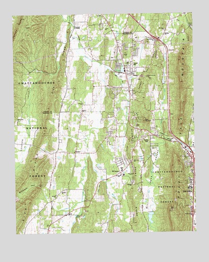
Tunnel Hill, GA USGS Topographic Map
Click on map above to begin viewing in our Map Viewer.

This topographic map contains these locations and features:
Feature Name Type Latitude Longitude GNIS ID View Map
Bell BranchStreamN34.8040°W85.0761°327061View Map
Blue MountainSummitN34.8137°W85.0347°354780View Map
Callaway CemeteryCemeteryN34.7904°W85.0816°327326View Map
Callaway MillPopulated PlaceN34.8331°W85.0602°331309View Map
Catoosa County Fire Department Station 5BuildingN34.8533°W85.0711°2604682View Map
Chetoogeta Mountain TunnelTunnelN34.8387°W85.0333°327446View Map
City of Tunnel HillCivilN34.8478°W85.0406°2405611View Map
Cobblestone LakeReservoirN34.8431°W85.0492°327478View Map
Cobblestone Lake DamDamN34.8412°W85.0494°337024View Map
Cook Lake (historical)ReservoirN34.8604°W85.0258°353383View Map
Copeland CrossingPopulated PlaceN34.8670°W85.0813°355304View Map
Cove CreekStreamN34.7676°W85.0791°327534View Map
Cove GapGapN34.7759°W85.1072°327535View Map
Dalton State CollegeSchoolN34.7751°W85.0029°327588View Map
Dedmon CemeteryCemeteryN34.8676°W85.1161°327617View Map
Dogwood CemeteryCemeteryN34.8251°W85.0772°355511View Map
Dogwood Christian AcademySchoolN34.8200°W85.0779°2545623View Map
Dogwood ChurchChurchN34.8195°W85.0772°355512View Map
Dogwood ValleyValleyN34.8443°W85.0625°327664View Map
Dry CreekStreamN34.8692°W85.0830°355557View Map
Dunnegan ChurchChurchN34.7740°W85.0924°330914View Map
Fellowship ChurchChurchN34.7776°W85.0444°330915View Map
First Baptist Church of Tunnel HillChurchN34.8462°W85.0427°353415View Map
Flying G Ranch AirportAirportN34.8677°W85.0604°2625383View Map
Foster CemeteryCemeteryN34.8542°W85.0416°327866View Map
Freeman SpringSpringN34.7601°W85.0811°327883View Map
Georgia State Patrol Troop A Post 5 DaltonBuildingN34.8007°W85.0120°2733950View Map
Gillilan LakeReservoirN34.8267°W85.0203°337007View Map
Griffin LakeReservoirN34.8359°W85.0209°337023View Map
Griffin Lake DamDamN34.8351°W85.0199°337022View Map
Harris GapGapN34.8665°W85.0013°328080View Map
Hassler MillPopulated PlaceN34.8020°W85.0180°331926View Map
Hiawassee Land Company LakeReservoirN34.7584°W85.0314°337033View Map
Hickory Grove ChurchChurchN34.8148°W85.1225°330903View Map
Hickory Grove School (historical)SchoolN34.8151°W85.1222°353271View Map
Hopkins BranchStreamN34.7959°W85.0741°328213View Map
Houston ValleyValleyN34.8416°W85.1053°328237View Map
Houston Valley ChurchChurchN34.8415°W85.1147°328238View Map
Interchange 136CrossingN34.7612°W85.0024°330905View Map
Interchange 137CrossingN34.7934°W85.0011°330673View Map
Interchange 138CrossingN34.8606°W85.0261°330984View Map
Lakeside ChurchChurchN34.7606°W85.0888°330913View Map
Liberty ChurchChurchN34.7740°W85.0924°328499View Map
McCutcheon CoveValleyN34.7741°W85.1055°328739View Map
Meadow LakeReservoirN34.8629°W85.0520°328754View Map
Mill Creek GapGapN34.8012°W85.0116°356392View Map
Mill Creek ValleyValleyN34.8047°W85.0254°328793View Map
Mill Creek Watershed Dam Number 10DamN34.8251°W85.0199°337006View Map
Mill Creek Watershed Dam Number SevenDamN34.7617°W85.0299°337032View Map
Mont Lily Station (historical)LocaleN34.8029°W85.0127°353456View Map
Mount Salem ChurchChurchN34.7709°W85.0963°328898View Map
Mount VernonPopulated PlaceN34.7842°W85.0519°353463View Map
Mount Vernon ChurchChurchN34.7840°W85.0516°328907View Map
Mount Vernon ChurchChurchN34.8126°W85.0544°353464View Map
Mount Vernon CreekStreamN34.8376°W85.0502°328909View Map
New Hope CemeteryCemeteryN34.8653°W85.0194°329000View Map
New Hope ChurchChurchN34.8634°W85.0191°329011View Map
North Fork Mill CreekStreamN34.8029°W85.0194°330906View Map
North Whitfield ChurchChurchN34.8559°W85.0519°353470View Map
Pine Hill ChurchChurchN34.8731°W85.0619°329219View Map
Rays GapGapN34.7673°W85.0147°353477View Map
Rocky Acres Bible CampLocaleN34.7801°W85.0230°329481View Map
Rocky FacePopulated PlaceN34.8051°W85.0274°332893View Map
Rocky Face Baptist ChurchChurchN34.8070°W85.0266°353481View Map
Rocky Face CemeteryCemeteryN34.7976°W85.0299°329494View Map
Rocky Face MountainSummitN34.7873°W85.0149°332895View Map
Rocky Face Post OfficePost OfficeN34.8035°W85.0258°353483View Map
Spriggs Mill (historical)LocaleN34.7598°W85.0319°353491View Map
Stony Point CemeteryCemeteryN34.7912°W85.0422°329859View Map
Stony Point ChurchChurchN34.7892°W85.0444°329860View Map
Stony Point RidgeRidgeN34.7751°W85.0449°329861View Map
Tanyard CreekStreamN34.8459°W85.0630°329930View Map
TrickumPopulated PlaceN34.7962°W85.0827°333262View Map
Trickum School (historical)SchoolN34.7962°W85.0830°353499View Map
Tunnel HillPopulated PlaceN34.8406°W85.0427°333273View Map
Tunnel Hill Elementary SchoolSchoolN34.8460°W85.0451°330904View Map
Tunnel Hill Police DepartmentBuildingN34.8471°W85.0393°2733756View Map
Tunnel Hill Post OfficePost OfficeN34.8428°W85.0430°353501View Map
Tunnel Hill RidgeRidgeN34.8365°W85.0344°330064View Map
West Side High SchoolSchoolN34.7856°W85.0505°330226View Map
Westside Elementary SchoolSchoolN34.7828°W85.0495°330227View Map
Westside Middle SchoolSchoolN34.7855°W85.0511°2545591View Map
Whitfield County Fire Department Station 6BuildingN34.7623°W85.0876°2604714View Map
Whitfield County Fire Department Station 7BuildingN34.8484°W85.0418°2604795View Map
WTTI Radio TowersTowerN34.7842°W85.0455°330916View Map
WTTI-AM (Dalton)TowerN34.7859°W85.0444°352418View Map

Note: Coordinates in the location and feature list above are referenced to NAD83 datum.


Copyright (C) 2008-2024 Ryan Niemi / Sunset Dynamics ... All Rights Reserved