TopoQuest Logo
Do you find TopoQuest useful?
Help keep TopoQuest running and adding new maps/features by donating!
Bitcoin:  19c7KJd3qBynnjoSw5npx9KScwjBe4ifkT
Litecoin:  LXs6TkuXGGXo1vDsWCkWVdjQX94eUKd6ui
Home View Maps Find Maps Find Places Resources & Links


Trion, Georgia Topographic Map

USGS Map Title: Trion, GA
USGS Map MRC: 34085E3
DRG (GeoTIFF) Download: o34085e3.tif


Neighboring USGS Topographic Map Quads:


  Cedar Grove, GA  
34085F4
 

  LaFayette, GA  
34085F3
 

  Catlett, GA  
34085F2
 

  Dougherty Gap, GA  
34085E4
 

  Trion, GA  
34085E3
 

  Subligna, GA  
34085E2
 

  Lyerly, GA  
34085D4
 

  Summerville, GA  
34085D3
 

  Armuchee, GA  
34085D2


Map MRC Location:

N35°
W86°
N35°
W85°
H8 H7 H6 H5 H4 H3 H2 H1
G8 G7 G6 G5 G4 G3 G2 G1
F8 F7 F6 F5 F4 F3 F2 F1
E8 E7 E6 E5 E4 E3 E2 E1
D8 D7 D6 D5 D4 D3 D2 D1
C8 C7 C6 C5 C4 C3 C2 C1
B8 B7 B6 B5 B4 B3 B2 B1
A8 A7 A6 A5 A4 A3 A2 A1
N34°
W86°
N34°
W85°

Trion, GA USGS 1:24K Topographic Map Preview:
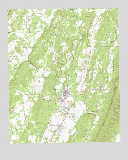
Trion, GA USGS Topographic Map
Click on map above to begin viewing in our Map Viewer.

This topographic map contains these locations and features:
Feature Name Type Latitude Longitude GNIS ID View Map
Alexanders Mill (historical)LocaleN34.5462°W85.2927°344414View Map
Algood CemeteryCemeteryN34.5395°W85.3219°344415View Map
Cane CreekStreamN34.5559°W85.3133°327351View Map
Carp LakeLakeN34.5614°W85.3195°327361View Map
Center PostPopulated PlaceN34.6081°W85.3530°355086View Map
Center Post SchoolSchoolN34.6076°W85.3533°353983View Map
Central Avenue Baptist ChurchChurchN34.5506°W85.3055°344425View Map
Chappel CreekStreamN34.5398°W85.3005°327408View Map
Chattooga Academy (historical)SchoolN34.6184°W85.3519°353989View Map
Chattooga CemeteryCemeteryN34.6187°W85.3522°353991View Map
Chattooga ChurchChurchN34.6184°W85.3513°355128View Map
Chattooga County Crossroads Alternative SchoolSchoolN34.5174°W85.3159°2545765View Map
Chattooga County HomeBuildingN34.5143°W85.3330°344427View Map
Chattooga Emergency Medical Services TrionBuildingN34.5428°W85.3160°2625460View Map
Dry ValleyValleyN34.5696°W85.3360°327700View Map
Dry Valley Baptist ChurchChurchN34.5456°W85.3491°355559View Map
Duck CreekStreamN34.5987°W85.3452°327703View Map
Duck Creek (historical)Populated PlaceN34.5812°W85.3677°344437View Map
East TrionPopulated PlaceN34.5465°W85.2916°331626View Map
East Trion Church of GodChurchN34.5451°W85.3086°344438View Map
Euthtilloga (historical)Populated PlaceN34.5834°W85.3661°344441View Map
Fellowship Baptist ChurchChurchN34.5302°W85.3123°2741326View Map
First Baptist Church of TrionChurchN34.5398°W85.3144°344447View Map
Gibson FieldAirportN34.6104°W85.3388°2625393View Map
Greenhill Memory GardenCemeteryN34.5065°W85.3208°328004View Map
Hall CemeteryCemeteryN34.5973°W85.2519°328037View Map
Halls Valley ChurchChurchN34.5934°W85.2558°328042View Map
Hammonds Mill (historical)LocaleN34.5820°W85.3527°344453View Map
Hammonds Store (historical)LocaleN34.5679°W85.2927°344454View Map
HawkinsPopulated PlaceN34.6042°W85.3744°331930View Map
Hays State PrisonBuildingN34.5077°W85.3126°2735714View Map
Howell CemeteryCemeteryN34.5706°W85.2624°328242View Map
Lake Wanda ReitaReservoirN34.5086°W85.3420°330156View Map
Lake Wanda Reita DamDamN34.5087°W85.3391°337142View Map
Leroy Massey Elementary SchoolSchoolN34.5098°W85.3313°2545764View Map
Lookout Hall ChurchChurchN34.5768°W85.3747°328642View Map
MartindalePopulated PlaceN34.6229°W85.3022°332325View Map
Mount Ridge ChurchChurchN34.5237°W85.2691°318868View Map
Mountain View Baptist ChurchChurchN34.5490°W85.2769°344472View Map
Napier ChapelChurchN34.6115°W85.3591°328973View Map
Napier Chapel School (historical)SchoolN34.6115°W85.3597°354144View Map
Narrows Lookout TowerTowerN34.5495°W85.2536°344303View Map
New Antioch Baptist ChurchChurchN34.5023°W85.3686°328990View Map
New Bethel ChurchChurchN34.5820°W85.2858°328994View Map
OaktonPopulated PlaceN34.5995°W85.2869°329083View Map
Old Way ChurchChurchN34.5992°W85.2850°354156View Map
Paynes Chapel CemeteryCemeteryN34.6115°W85.3455°329151View Map
PennvillePopulated PlaceN34.5123°W85.3213°332638View Map
Pennville Baptist ChurchChurchN34.5056°W85.3255°344475View Map
Pennville SchoolSchoolN34.5173°W85.3158°344476View Map
Pleasant Grove ChurchChurchN34.5690°W85.2911°329257View Map
Ridgedale Unity ChurchChurchN34.5056°W85.2866°329432View Map
Ridgeway ChurchChurchN34.6065°W85.3177°329434View Map
Round LakeLakeN34.5498°W85.3188°329536View Map
Saint Peters ChanelChurchN34.5001°W85.3313°329564View Map
Selmans LakeReservoirN34.5279°W85.2828°329641View Map
Spring BranchStreamN34.5451°W85.3100°329789View Map
Spring CreekStreamN34.5290°W85.2897°329793View Map
Spring CreekStreamN34.5790°W85.3550°329794View Map
Spring Creek Baptist ChurchChurchN34.5276°W85.2786°329797View Map
Sucker LakeLakeN34.5586°W85.3182°329877View Map
Taylor RidgeRidgeN34.5495°W85.2541°329949View Map
Teloga CreekStreamN34.5781°W85.3575°329952View Map
Town of TrionCivilN34.5479°W85.3108°2406756View Map
Triangle Shopping CenterLocaleN34.5343°W85.3069°344506View Map
Trinity CemeteryCemeteryN34.6106°W85.3547°354207View Map
Trinity ChurchChurchN34.6117°W85.3527°330051View Map
TrionPopulated PlaceN34.5440°W85.3105°333265View Map
Trion CemeteryCemeteryN34.5454°W85.3030°344507View Map
Trion DivisionCivilN34.5500°W85.3082°1936598View Map
Trion Elementary SchoolSchoolN34.5382°W85.3255°2545670View Map
Trion Fire DepartmentBuildingN34.5470°W85.3096°2604855View Map
Trion Heights Baptist ChurchChurchN34.5281°W85.3138°324321View Map
Trion High SchoolSchoolN34.5382°W85.3251°344508View Map
Trion Industrial ParkLocaleN34.5418°W85.2944°344509View Map
Trion Middle SchoolSchoolN34.5382°W85.3248°2545671View Map
Trion Police DepartmentBuildingN34.5429°W85.3124°2734195View Map
Trion Presbyterian ChurchChurchN34.5412°W85.3122°344510View Map
Trion Town HallBuildingN34.5431°W85.3125°344511View Map
Trion United Methodist ChurchChurchN34.5406°W85.3161°344512View Map
Union ChurchChurchN34.5404°W85.3211°330100View Map
Valley Store (historical)LocaleN34.5781°W85.3722°344514View Map
Waterville ChurchChurchN34.6234°W85.2522°330174View Map
Welcome HillPopulated PlaceN34.5748°W85.3186°330199View Map
Welcome Hill Baptist ChurchChurchN34.5743°W85.2694°344515View Map
Wesley ChapelChurchN34.6176°W85.2827°330206View Map
Wesley Chapel CemeteryCemeteryN34.6176°W85.2841°354225View Map
Wesley Chapel School (historical)SchoolN34.6176°W85.2836°354226View Map
West Hill CemeteryCemeteryN34.5365°W85.3188°330222View Map
Williams CemeteryCemeteryN34.5645°W85.2761°330294View Map

Note: Coordinates in the location and feature list above are referenced to NAD83 datum.


Copyright (C) 2008-2024 Ryan Niemi / Sunset Dynamics ... All Rights Reserved