TopoQuest Logo
Do you find TopoQuest useful?
Help keep TopoQuest running and adding new maps/features by donating!
Bitcoin:  19c7KJd3qBynnjoSw5npx9KScwjBe4ifkT
Litecoin:  LXs6TkuXGGXo1vDsWCkWVdjQX94eUKd6ui
Home View Maps Find Maps Find Places Resources & Links


Tranquility, New Jersey Topographic Map

USGS Map Title: Tranquility, NJ
USGS Map MRC: 40074H7
DRG (GeoTIFF) Download: o40074h7.tif


Neighboring USGS Topographic Map Quads:


  Flatbrookville, NJ  
41074A8
 

  Newton West, NJ  
41074A7
 

  Newton East, NJ  
41074A6
 

  Blairstown, NJ  
40074H8
 

  Tranquility, NJ  
40074H7
 

  Stanhope, NJ  
40074H6
 

  Washington, NJ  
40074G8
 

  Hackettstown, NJ  
40074G7
 

  Chester, NJ  
40074G6


Map MRC Location:

N41°
W75°
N41°
W74°
H8 H7 H6 H5 H4 H3 H2 H1
G8 G7 G6 G5 G4 G3 G2 G1
F8 F7 F6 F5 F4 F3 F2 F1
E8 E7 E6 E5 E4 E3 E2 E1
D8 D7 D6 D5 D4 D3 D2 D1
C8 C7 C6 C5 C4 C3 C2 C1
B8 B7 B6 B5 B4 B3 B2 B1
A8 A7 A6 A5 A4 A3 A2 A1
N40°
W75°
N40°
W74°

Tranquility, NJ USGS 1:24K Topographic Map Preview:
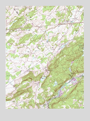
Tranquility, NJ USGS Topographic Map
Click on map above to begin viewing in our Map Viewer.

This topographic map contains these locations and features:
Feature Name Type Latitude Longitude GNIS ID View Map
Alla Valley DairyLocaleN40.9317°W74.8353°2709461View Map
AllamuchyPopulated PlaceN40.9218°W74.8102°874292View Map
Allamuchy - Green First Aid SquadBuildingN40.9491°W74.8047°2659780View Map
Allamuchy Census Designated PlaceCensusN40.9222°W74.8115°2583964View Map
Allamuchy MountainSummitN40.9357°W74.7729°874293View Map
Allamuchy PondReservoirN40.9116°W74.8156°874294View Map
Allamuchy Pond DamDamN40.9140°W74.8104°884309View Map
Allamuchy Post OfficePost OfficeN40.9041°W74.8239°2781403View Map
Allamuchy Township Volunteer Fire DepartmentBuildingN40.9119°W74.8520°2613818View Map
Allamuchy-Panther Valley Census Designated Place (historical)CensusN40.9123°W74.8302°2389123View Map
AlphanoPopulated PlaceN40.9023°W74.8616°874319View Map
BrightonPopulated PlaceN40.9851°W74.7635°874942View Map
Brighton LakeReservoirN40.9870°W74.7704°883628View Map
Buckmire PondLakeN40.9680°W74.7609°875006View Map
Chemy CreekStreamN40.9309°W74.7710°2118220View Map
Cranberry Bog RunStreamN40.9386°W74.7525°2118221View Map
Deer Park PondReservoirN40.9055°W74.7955°875860View Map
Deer Park Pond DamDamN40.9040°W74.7924°884307View Map
Francis LakeLakeN40.9713°W74.8391°876459View Map
Frelinghuysen Township Municipal BuildingBuildingN40.9665°W74.8741°2043390View Map
Frenches PondReservoirN40.9223°W74.7719°876510View Map
Frenches Pond DamDamN40.9259°W74.7724°884306View Map
Grass PondLakeN40.9865°W74.8362°876714View Map
Green Township Volunteer Fire DepartmentBuildingN40.9729°W74.8202°2613910View Map
GreendellPopulated PlaceN40.9740°W74.8210°876797View Map
Greendell Post OfficePost OfficeN40.9728°W74.8199°2781432View Map
High RocksSummitN40.9840°W74.8518°877102View Map
HuntsburgPopulated PlaceN40.9973°W74.8377°877288View Map
HuntsvillePopulated PlaceN40.9804°W74.7754°877289View Map
Lake TranquilityReservoirN40.9519°W74.7816°881234View Map
Ledge RunStreamN40.9483°W74.7517°2118236View Map
Long BridgePopulated PlaceN40.9201°W74.8402°877909View Map
Mount Allamuchy CampLocaleN40.9176°W74.7699°878515View Map
Mud PondLakeN40.9812°W74.8591°878634View Map
Ninety Five Mile Tree Lookout TowerTowerN40.8951°W74.7502°884460View Map
Panther Valley Census Designated PlaceCensusN40.9078°W74.8412°2584015View Map
PetersburgPopulated PlaceN40.8795°W74.8577°879256View Map
Quaker ChurchLocaleN40.9448°W74.8349°879561View Map
Saxton FallsPopulated PlaceN40.8898°W74.7960°880278View Map
Saxton Falls DamDamN40.8884°W74.7979°884308View Map
Saxton LakeLakeN40.8919°W74.7906°880279View Map
Teeny CreekStreamN40.9239°W74.7786°2118237View Map
Tiny CreekStreamN40.9236°W74.7742°2118238View Map
Tow Path CreekStreamN40.9122°W74.7676°2118239View Map
Township of AllamuchyCivilN40.9188°W74.8300°882243View Map
Township of GreenCivilN40.9741°W74.7979°882264View Map
TranquilityPopulated PlaceN40.9562°W74.8085°881235View Map
Tranquility ChurchChurchN40.9468°W74.7971°881233View Map
Tranquility DamDamN40.9490°W74.7866°884305View Map
Tranquility Post OfficePost OfficeN40.9497°W74.7999°2781503View Map
Trinca AirportAirportN40.9660°W74.7817°884640View Map
Trout BrookStreamN40.9221°W74.8375°881266View Map
Turtle PondLakeN40.9804°W74.7685°881308View Map
Villa MadonnaPopulated PlaceN40.9145°W74.8124°881454View Map
WaterlooPopulated PlaceN40.9151°W74.7543°881618View Map
Waterloo LakesReservoirN40.9165°W74.7506°881619View Map
Weaver House RunStreamN40.9483°W74.7536°2118240View Map
WeirtownPopulated PlaceN40.9048°W74.8221°881654View Map
Weiss Farm AirportAirportN40.9182°W74.8606°2625363View Map
Yellow FrameLocaleN40.9962°W74.8607°881983View Map

Note: Coordinates in the location and feature list above are referenced to NAD83 datum.


Copyright (C) 2008-2024 Ryan Niemi / Sunset Dynamics ... All Rights Reserved