TopoQuest Logo
Do you find TopoQuest useful?
Help keep TopoQuest running and adding new maps/features by donating!
Bitcoin:  19c7KJd3qBynnjoSw5npx9KScwjBe4ifkT
Litecoin:  LXs6TkuXGGXo1vDsWCkWVdjQX94eUKd6ui
Home View Maps Find Maps Find Places Resources & Links


Blue Mountain, Arkansas Topographic Map

USGS Map Title: Blue Mountain, AR
USGS Map MRC: 35093B6
DRG (GeoTIFF) Download: o35093b6.tif


Neighboring USGS Topographic Map Quads:


  Caulksville, AR  
35093C7
 

  Paris, AR  
35093C6
 

  Scranton, AR  
35093C5
 

  Magazine, AR  
35093B7
 

  Blue Mountain, AR  
35093B6
 

  Magazine Mountain NE, AR  
35093B5
 

  Sugar Grove, AR  
35093A7
 

  Blue Mountain Dam, AR  
35093A6
 

  Havana, AR  
35093A5


Map MRC Location:

N36°
W94°
N36°
W93°
H8 H7 H6 H5 H4 H3 H2 H1
G8 G7 G6 G5 G4 G3 G2 G1
F8 F7 F6 F5 F4 F3 F2 F1
E8 E7 E6 E5 E4 E3 E2 E1
D8 D7 D6 D5 D4 D3 D2 D1
C8 C7 C6 C5 C4 C3 C2 C1
B8 B7 B6 B5 B4 B3 B2 B1
A8 A7 A6 A5 A4 A3 A2 A1
N35°
W94°
N35°
W93°

Blue Mountain, AR USGS 1:24K Topographic Map Preview:
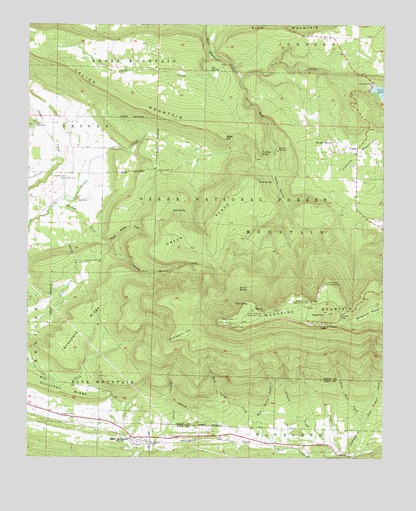
Blue Mountain, AR USGS Topographic Map
Click on map above to begin viewing in our Map Viewer.

This topographic map contains these locations and features:
Feature Name Type Latitude Longitude GNIS ID View Map
Ball SpringSpringN35.1964°W93.6995°70500View Map
Blue MountainPopulated PlaceN35.1304°W93.7116°70733View Map
Blue Mountain Post OfficePost OfficeN35.1304°W93.7110°2781837View Map
Blue Mountain Volunteer Fire StationBuildingN35.1300°W93.7118°2116162View Map
Bray SpringSpringN35.2048°W93.6694°70806View Map
Brown SpringSpringN35.2142°W93.6592°70848View Map
Brown Springs Recreation AreaParkN35.1698°W93.6507°70849View Map
Burnett SpringSpringN35.2162°W93.6429°70930View Map
Calico CreekStreamN35.2423°W93.6869°70957View Map
Calico MountainSummitN35.2406°W93.7424°70959View Map
Cameron BluffCliffN35.1726°W93.6427°74366View Map
Cameron Bluff Recreation AreaParkN35.1756°W93.6457°70966View Map
Cockrell CreekStreamN35.1259°W93.6388°71179View Map
Cold SpringSpringN35.1697°W93.6774°71186View Map
CorleyPopulated PlaceN35.2134°W93.6346°71232View Map
Cove CreekStreamN35.2351°W93.6760°71246View Map
Cove Lake DamDamN35.2318°W93.6302°80610View Map
Cove Lake Picnic AreaLocaleN35.2137°W93.6288°74481View Map
Cove Lake Recreation AreaParkN35.2284°W93.6266°64257View Map
Crowell CreekStreamN35.1256°W93.6413°71297View Map
Donathan RidgeRidgeN35.1434°W93.7355°71407View Map
Dripping Springs Recreation AreaParkN35.1681°W93.6710°76820View Map
East Bass CreekStreamN35.1348°W93.6330°71492View Map
East Lacey CreekStreamN35.1340°W93.6682°71516View Map
Ellington CemeteryCemeteryN35.1370°W93.7380°71551View Map
Green BenchBenchN35.1915°W93.6896°71833View Map
Gutter Rock CreekStreamN35.2348°W93.6763°71868View Map
Hope LakeReservoirN35.2272°W93.7264°81104View Map
Hope Lake DamDamN35.2268°W93.7269°81103View Map
House GapGapN35.1654°W93.6396°72092View Map
Huckleberry FlatFlatN35.1612°W93.6949°72104View Map
Jenkins CemeteryCemeteryN35.2056°W93.7377°72175View Map
Jug SpringSpringN35.2370°W93.6862°72226View Map
KMAG-FM (Fort Smith)TowerN35.1656°W93.6766°85393View Map
Liberty ChurchChurchN35.2212°W93.7480°72326View Map
Lick CreekStreamN35.1987°W93.6599°74480View Map
Little Hope CemeteryCemeteryN35.2079°W93.7044°72398View Map
Logan CountyCivilN35.2153°W93.7163°82850View Map
Magazine Hiking TrailTrailN35.2029°W93.6582°74425View Map
Magazine Lookout TowerTowerN35.1634°W93.6788°82594View Map
Magazine MountainRidgeN35.1673°W93.6450°67051View Map
Magazine Mountain LodgeLocaleN35.1640°W93.6466°72538View Map
Mossback RidgeRidgeN35.1670°W93.6294°72743View Map
Mount Magazine Post Office (historical)Post OfficeN35.1640°W93.6466°2026806View Map
North Wicked CreekStreamN35.1876°W93.7227°72898View Map
Rana CemeteryCemeteryN35.2056°W93.7374°73232View Map
Ross HollowValleyN35.2093°W93.6632°73384View Map
Shaw CemeteryCemeteryN35.1998°W93.7330°73528View Map
Sheppard RidgeRidgeN35.1631°W93.7305°73535View Map
Short MountainSummitN35.2498°W93.7499°78357View Map
Signal HillSummitN35.1673°W93.6450°73578View Map
Slate HillSummitN35.2179°W93.6816°73602View Map
Slocum SpringSpringN35.1740°W93.6758°73610View Map
Smallwood CreekStreamN35.1254°W93.6366°73613View Map
South Wicked CreekStreamN35.1876°W93.7230°73656View Map
Town of Blue MountainCivilN35.1311°W93.7161°2405283View Map
Township of Blue MountainCivilN35.1385°W93.7183°68788View Map
Turkey KnobSummitN35.2134°W93.6688°73904View Map
West Bass CreekStreamN35.1348°W93.6327°74052View Map
West Lacey CreekStreamN35.1340°W93.6682°74075View Map
Wicked CreekStreamN35.1976°W93.7413°74143View Map

Note: Coordinates in the location and feature list above are referenced to NAD83 datum.


Copyright (C) 2008-2024 Ryan Niemi / Sunset Dynamics ... All Rights Reserved