TopoQuest Logo
Do you find TopoQuest useful?
Help keep TopoQuest running and adding new maps/features by donating!
Bitcoin:  19c7KJd3qBynnjoSw5npx9KScwjBe4ifkT
Litecoin:  LXs6TkuXGGXo1vDsWCkWVdjQX94eUKd6ui
Home View Maps Find Maps Find Places Resources & Links


Tobacco Row Mountain, Virginia Topographic Map

USGS Map Title: Tobacco Row Mountain, VA
USGS Map MRC: 37079E2
DRG (GeoTIFF) Download: o37079e2.tif


Neighboring USGS Topographic Map Quads:


  Buena Vista, VA  
37079F3
 

  Forks of Buffalo, VA  
37079F2
 

  Piney River, VA  
37079F1
 

  Big Island, VA  
37079E3
 

  Tobacco Row Mountain, VA  
37079E2
 

  Amherst, VA  
37079E1
 

  Boonsboro, VA  
37079D3
 

  Lynchburg, VA  
37079D2
 

  Kelly, VA  
37079D1


Map MRC Location:

N38°
W80°
N38°
W79°
H8 H7 H6 H5 H4 H3 H2 H1
G8 G7 G6 G5 G4 G3 G2 G1
F8 F7 F6 F5 F4 F3 F2 F1
E8 E7 E6 E5 E4 E3 E2 E1
D8 D7 D6 D5 D4 D3 D2 D1
C8 C7 C6 C5 C4 C3 C2 C1
B8 B7 B6 B5 B4 B3 B2 B1
A8 A7 A6 A5 A4 A3 A2 A1
N37°
W80°
N37°
W79°

Tobacco Row Mountain, VA USGS 1:24K Topographic Map Preview:
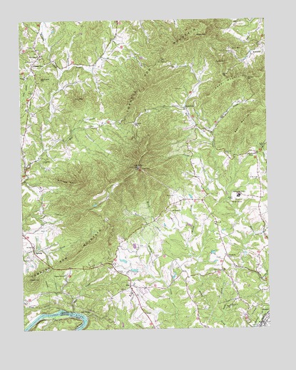
Tobacco Row Mountain, VA USGS Topographic Map
Click on map above to begin viewing in our Map Viewer.

This topographic map contains these locations and features:
Feature Name Type Latitude Longitude GNIS ID View Map
AgricolaPopulated PlaceN37.5313°W79.2439°1499044View Map
Amherst CountyCivilN37.6048°W79.1451°1480095View Map
Bear MountainSummitN37.5824°W79.1367°1462899View Map
Bethany ChurchChurchN37.5290°W79.1453°1463135View Map
Buffalo SpurRidgeN37.5593°W79.2259°1499182View Map
Burford CemeteryCemeteryN37.6151°W79.1275°1464101View Map
Camden GapGapN37.6007°W79.1345°1464299View Map
Cedar MountainSummitN37.5990°W79.1417°1464635View Map
Chestnut Grove Baptist ChurchChurchN37.5218°W79.2281°1464816View Map
Chestnut Grove School (historical)SchoolN37.5226°W79.2286°1707571View Map
Childress CreekStreamN37.5763°W79.1517°1464845View Map
Crab CreekStreamN37.5082°W79.2309°1482782View Map
Crawford GapGapN37.5835°W79.1920°1465417View Map
Crawfords StoreLocaleN37.5713°W79.1303°1465418View Map
Davies BranchStreamN37.5196°W79.1286°1465632View Map
ElonPopulated PlaceN37.5176°W79.1950°1499384View Map
Elon Baptist ChurchChurchN37.5149°W79.1950°1707575View Map
Elon Elementary SchoolSchoolN37.5136°W79.1957°1707576View Map
Elon Presbyterian ChurchChurchN37.5179°W79.1939°1707577View Map
Falling Rock CreekStreamN37.5374°W79.1322°1466460View Map
Father Judge Mission SeminarySchoolN37.5535°W79.1389°1466503View Map
Fletcher CemeteryCemeteryN37.5226°W79.1984°1466702View Map
Forest CreekStreamN37.5599°W79.1500°1466758View Map
Gatewood CemeteryCemeteryN37.6085°W79.2417°1467022View Map
General Alberts DamDamN37.5235°W79.1914°1489156View Map
General Alberts Other DamDamN37.5268°W79.1981°1489157View Map
Gum MountainSummitN37.6121°W79.1375°1499511View Map
Gun MountainSummitN37.5924°W79.2203°1467605View Map
Harris CemeteryCemeteryN37.5115°W79.2484°1467774View Map
Hicks CemeteryCemeteryN37.5151°W79.1259°1467993View Map
Hicks CemeteryCemeteryN37.5971°W79.1670°1467994View Map
Hicks StoreLocaleN37.5896°W79.1656°1467998View Map
High PeakSummitN37.5654°W79.1900°1468014View Map
Hudson CemeteryCemeteryN37.5285°W79.1817°1468348View Map
Hudson CemeteryCemeteryN37.5960°W79.2428°1468349View Map
Indian MissionChurchN37.5729°W79.1270°1707586View Map
Little Bethel ChurchChurchN37.5687°W79.2373°1469475View Map
Love Lady MountainSummitN37.6015°W79.2395°1469876View Map
Mill CreekStreamN37.5732°W79.2384°1470490View Map
Miller CreekStreamN37.5326°W79.1656°1470561View Map
Monelison Volunteer Fire Department Station 3BuildingN37.5196°W79.1956°2075632View Map
MonroePopulated PlaceN37.5021°W79.1278°1499756View Map
Mount Carmel ChurchChurchN37.5474°W79.1734°1470847View Map
Mount Tabor ChurchChurchN37.5332°W79.2439°1471077View Map
New Prospect Baptist ChurchChurchN37.6101°W79.2398°1471488View Map
Pedlar GapGapN37.6021°W79.1467°1472169View Map
Pedlar MountainSummitN37.6071°W79.1475°1499854View Map
Pleasant Chapel (historical)ChurchN37.5826°W79.2106°1707615View Map
Pleasant ViewPopulated PlaceN37.6062°W79.2439°1499886View Map
Pleasant View Elementary SchoolSchoolN37.6028°W79.2473°1472522View Map
Potato HillSummitN37.5196°W79.2448°1472701View Map
Pryor CreekStreamN37.6035°W79.2292°1472839View Map
Rocky Seat School (historical)SchoolN37.5765°W79.1606°1707622View Map
Saint Pauls CemeteryCemeteryN37.5601°W79.1295°1473859View Map
Saint Pauls Episcopal MissionChurchN37.5729°W79.1272°1707625View Map
Saint Pauls Mission SchoolSchoolN37.5726°W79.1267°1473897View Map
Sally CreekStreamN37.5032°W79.1492°1473971View Map
Salt CreekStreamN37.5068°W79.2242°1473975View Map
Salt CreekPopulated PlaceN37.5068°W79.2211°1500015View Map
Shady MountainSummitN37.6176°W79.1573°1474207View Map
Shiloh ChurchChurchN37.5710°W79.1456°1474513View Map
Smyrna ChurchChurchN37.5801°W79.1561°1474791View Map
Sunrise ChurchChurchN37.5090°W79.1445°1475339View Map
Timothy Baptist ChurchChurchN37.6146°W79.2420°1475732View Map
Tobacco Row MountainSummitN37.5654°W79.1900°1487937View Map
Watts CemeteryCemeteryN37.5537°W79.1720°1476397View Map
Watts SchoolSchoolN37.5088°W79.1445°1476399View Map
Weir GapGapN37.6087°W79.1775°1476434View Map

Note: Coordinates in the location and feature list above are referenced to NAD83 datum.


Copyright (C) 2008-2024 Ryan Niemi / Sunset Dynamics ... All Rights Reserved