TopoQuest Logo
Do you find TopoQuest useful?
Help keep TopoQuest running and adding new maps/features by donating!
Bitcoin:  19c7KJd3qBynnjoSw5npx9KScwjBe4ifkT
Litecoin:  LXs6TkuXGGXo1vDsWCkWVdjQX94eUKd6ui
Home View Maps Find Maps Find Places Resources & Links


Timothy, North Carolina Topographic Map

USGS Map Title: Timothy, NC
USGS Map MRC: 35078B4
DRG (GeoTIFF) Download: o35078b4.tif


Neighboring USGS Topographic Map Quads:


  Dunn, NC  
35078C5
 

  Peacocks Crossroads, NC  
35078C4
 

  Newton Grove North, NC  
35078C3
 

  Mingo, NC  
35078B5
 

  Timothy, NC  
35078B4
 

  Newton Grove South, NC  
35078B3
 

  Salemburg, NC  
35078A5
 

  Bearskin, NC  
35078A4
 

  Clinton North, NC  
35078A3


Map MRC Location:

N36°
W79°
N36°
W78°
H8 H7 H6 H5 H4 H3 H2 H1
G8 G7 G6 G5 G4 G3 G2 G1
F8 F7 F6 F5 F4 F3 F2 F1
E8 E7 E6 E5 E4 E3 E2 E1
D8 D7 D6 D5 D4 D3 D2 D1
C8 C7 C6 C5 C4 C3 C2 C1
B8 B7 B6 B5 B4 B3 B2 B1
A8 A7 A6 A5 A4 A3 A2 A1
N35°
W79°
N35°
W78°

Timothy, NC USGS 1:24K Topographic Map Preview:
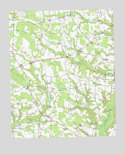
Timothy, NC USGS Topographic Map
Click on map above to begin viewing in our Map Viewer.

This topographic map contains these locations and features:
Feature Name Type Latitude Longitude GNIS ID View Map
Blackmans Grove ChurchChurchN35.2174°W78.4411°1007537View Map
Blackmans MillsPopulated PlaceN35.2479°W78.4078°1006132View Map
Blackmans PondReservoirN35.2468°W78.4247°1025164View Map
Blackmans Pond DamDamN35.2468°W78.4247°1025883View Map
Crestview ChurchChurchN35.2082°W78.4972°1007531View Map
Daughtry BridgeBridgeN35.1493°W78.3811°983965View Map
Enterprise SchoolSchoolN35.2335°W78.4983°984815View Map
Glencoe School (historical)SchoolN35.1493°W78.3953°1952616View Map
Goodwin ChurchChurchN35.1691°W78.4367°985808View Map
Herrings CrossroadsPopulated PlaceN35.1746°W78.3958°1027408View Map
Hickory Grove ChurchChurchN35.1332°W78.4331°1007528View Map
Hopewell ChurchChurchN35.1771°W78.3981°1007505View Map
Houses PondReservoirN35.1879°W78.3799°1005922View Map
Jacksons PondReservoirN35.1402°W78.4897°998429View Map
Jacksons Pond DamDamN35.1402°W78.4897°998430View Map
Little Field CemeteryCemeteryN35.2046°W78.4011°1007534View Map
Little Field ChurchChurchN35.2063°W78.4200°1007506View Map
Long BranchStreamN35.1399°W78.4939°1025496View Map
Maple Grove SchoolSchoolN35.2382°W78.4503°989309View Map
McLamb CrossroadsPopulated PlaceN35.2002°W78.3853°1006290View Map
McPhail BranchStreamN35.1521°W78.4058°989644View Map
Merkle SwampStreamN35.1346°W78.3872°1027426View Map
MidwayPopulated PlaceN35.1602°W78.4703°1005920View Map
Midway High SchoolSchoolN35.1754°W78.4789°1007532View Map
Mount Carmel ChurchChurchN35.2435°W78.4939°1007538View Map
Mounty Elam ChurchChurchN35.1566°W78.4995°1007530View Map
Oak Grove CemeteryCemeteryN35.2065°W78.3919°1007535View Map
Oak Grove ChurchChurchN35.2171°W78.4011°991366View Map
Oak Grove School (historical)SchoolN35.2166°W78.4022°1952620View Map
Opossum SwampStreamN35.1391°W78.4956°991669View Map
Point Level ChurchChurchN35.1363°W78.4175°1007527View Map
Red HillPopulated PlaceN35.1479°W78.3892°1022190View Map
Roanoke ChapelChurchN35.1710°W78.4394°1007533View Map
Rosin HillPopulated PlaceN35.2085°W78.4142°993720View Map
Sampson Acres LakeReservoirN35.1635°W78.4214°998460View Map
Sampson Acres Lake DamDamN35.1635°W78.4214°998459View Map
Sevenmile ChurchChurchN35.1829°W78.3958°1007536View Map
Shady Grove ChurchChurchN35.1985°W78.4728°1026180View Map
Shady Grove School (historical)SchoolN35.1985°W78.4728°1025692View Map
Sinclair LakeReservoirN35.1632°W78.4540°1027434View Map
Sinclair Lake DamDamN35.1563°W78.4539°998461View Map
Spivey's Corner Census Designated PlaceCensusN35.1982°W78.4826°2402887View Map
Spiveys CornerPopulated PlaceN35.1954°W78.4872°1001104View Map
Spiveys Corner Volunteer Fire DepartmentBuildingN35.1967°W78.4841°2639188View Map
TimothyPopulated PlaceN35.2254°W78.4600°996114View Map
Township of WestbrookCivilN35.2151°W78.4323°1027186View Map
Vann CrossroadsPopulated PlaceN35.1754°W78.3981°1005921View Map
Vann Crossroads Census Designated PlaceCensusN35.1696°W78.4026°2402963View Map
Vann Crossroads Fire DepartmentBuildingN35.1757°W78.3976°2639578View Map
Warren MillpondReservoirN35.1354°W78.4978°996803View Map
Warrens PondReservoirN35.2383°W78.3976°1026030View Map
Williams ChapelChurchN35.1571°W78.4681°1007529View Map
Wilsons StoreLocaleN35.1963°W78.4803°997463View Map

Note: Coordinates in the location and feature list above are referenced to NAD83 datum.


Copyright (C) 2008-2024 Ryan Niemi / Sunset Dynamics ... All Rights Reserved