TopoQuest Logo
Do you find TopoQuest useful?
Help keep TopoQuest running and adding new maps/features by donating!
Bitcoin:  19c7KJd3qBynnjoSw5npx9KScwjBe4ifkT
Litecoin:  LXs6TkuXGGXo1vDsWCkWVdjQX94eUKd6ui
Home View Maps Find Maps Find Places Resources & Links


Three Islands, Texas Topographic Map

USGS Map Title: Three Islands, TX
USGS Map MRC: 26097C3
DRG (GeoTIFF) Download: o26097c3.tif


Neighboring USGS Topographic Map Quads:


  Hawk Island, TX  
26097D4
 

  Green Island, TX  
26097D3
 

  North of Port Isabel NW, TX  
26097D2
 

  La Leona, TX  
26097C4
 

  Three Islands, TX  
26097C3
 

  North of Port Isabel SW, TX  
26097C2
 

  Laguna Atascosa, TX  
26097B4
 

  La Coma, TX  
26097B3
 

  Port Isabel NW, TX  
26097B2


Map MRC Location:

N27°
W98°
N27°
W97°
H8 H7 H6 H5 H4 H3 H2 H1
G8 G7 G6 G5 G4 G3 G2 G1
F8 F7 F6 F5 F4 F3 F2 F1
E8 E7 E6 E5 E4 E3 E2 E1
D8 D7 D6 D5 D4 D3 D2 D1
C8 C7 C6 C5 C4 C3 C2 C1
B8 B7 B6 B5 B4 B3 B2 B1
A8 A7 A6 A5 A4 A3 A2 A1
N26°
W98°
N26°
W97°

Three Islands, TX USGS 1:24K Topographic Map Preview:
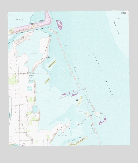
Three Islands, TX USGS Topographic Map
Click on map above to begin viewing in our Map Viewer.

This topographic map contains these locations and features:
Feature Name Type Latitude Longitude GNIS ID View Map
Caballo IslandIslandN26.2926°W97.3005°1331801View Map
Colorado IslandIslandN26.3631°W97.3480°1333143View Map
El Morro IslandIslandN26.3665°W97.3416°1335220View Map
El Realito BayBayN26.2559°W97.3078°1335257View Map
El Realito PeninsulaCapeN26.2540°W97.3025°1335258View Map
Heron IslandIslandN26.3176°W97.3344°1337652View Map
Horse IslandIslandN26.3392°W97.3375°1338107View Map
Los Bencos de en MedioIslandN26.3731°W97.2508°1340570View Map
McGilvery IslandIslandN26.3581°W97.3719°1341205View Map
Medio IslandIslandN26.2798°W97.2936°1341327View Map
North PointCapeN26.3515°W97.3575°1342787View Map
Primero IslandIslandN26.2801°W97.2841°1344567View Map
Rancho Buena Vista AirportAirportN26.2513°W97.3073°1386219View Map
Rattlesnake IslandIslandN26.3270°W97.3289°1344821View Map
Red Head BluffCliffN26.3017°W97.3478°1344923View Map
Red Head CoveBayN26.3151°W97.3514°1344924View Map
Rincon Buena VistaCapeN26.3567°W97.3489°1345225View Map
Rincon de GuajardoCapeN26.2673°W97.3191°1345219View Map
Three IslandsIslandN26.2770°W97.2955°1348521View Map
Townsite PointCapeN26.2731°W97.3125°1348689View Map
Ultimo IslandIslandN26.2701°W97.3025°1349018View Map
Worth PointCapeN26.3490°W97.3530°1350593View Map
Yucca IslandIslandN26.3109°W97.3350°1350709View Map

Note: Coordinates in the location and feature list above are referenced to NAD83 datum.


Copyright (C) 2008-2024 Ryan Niemi / Sunset Dynamics ... All Rights Reserved