TopoQuest Logo
Do you find TopoQuest useful?
Help keep TopoQuest running and adding new maps/features by donating!
Bitcoin:  19c7KJd3qBynnjoSw5npx9KScwjBe4ifkT
Litecoin:  LXs6TkuXGGXo1vDsWCkWVdjQX94eUKd6ui
Home View Maps Find Maps Find Places Resources & Links


Blue Creek, West Virginia Topographic Map

USGS Map Title: Blue Creek, WV
USGS Map MRC: 38081D4
DRG (GeoTIFF) Download: o38081d4.tif


Neighboring USGS Topographic Map Quads:


  Romance, WV  
38081E5
 

  Kettle, WV  
38081E4
 

  Clio, WV  
38081E3
 

  Big Chimney, WV  
38081D5
 

  Blue Creek, WV  
38081D4
 

  Clendenin, WV  
38081D3
 

  Charleston East, WV  
38081C5
 

  Quick, WV  
38081C4
 

  Mammoth, WV  
38081C3


Map MRC Location:

N39°
W82°
N39°
W81°
H8 H7 H6 H5 H4 H3 H2 H1
G8 G7 G6 G5 G4 G3 G2 G1
F8 F7 F6 F5 F4 F3 F2 F1
E8 E7 E6 E5 E4 E3 E2 E1
D8 D7 D6 D5 D4 D3 D2 D1
C8 C7 C6 C5 C4 C3 C2 C1
B8 B7 B6 B5 B4 B3 B2 B1
A8 A7 A6 A5 A4 A3 A2 A1
N38°
W82°
N38°
W81°

Blue Creek, WV USGS 1:24K Topographic Map Preview:
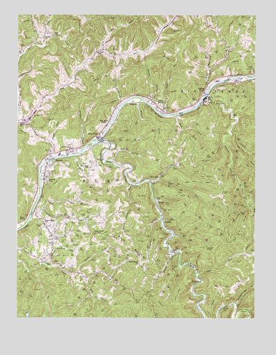
Blue Creek, WV USGS Topographic Map
Click on map above to begin viewing in our Map Viewer.

This topographic map contains these locations and features:
Feature Name Type Latitude Longitude GNIS ID View Map
Big ForkStreamN38.4851°W81.4557°1535841View Map
Big Fork School (historical)SchoolN38.4854°W81.4560°1535846View Map
Billy BranchStreamN38.4157°W81.4251°1536011View Map
Blue CreekStreamN38.4479°W81.4568°1536120View Map
Blue CreekPopulated PlaceN38.4507°W81.4573°1553929View Map
Blue Creek BridgeBridgeN38.4492°W81.4559°2647424View Map
Blue Creek ChapelChurchN38.4554°W81.4529°1536121View Map
Blue Creek Post OfficePost OfficeN38.4519°W81.4561°1742035View Map
Bridge Elementary SchoolSchoolN38.4449°W81.4669°1741852View Map
Buffalolick BranchStreamN38.4420°W81.4685°1536661View Map
CocoPopulated PlaceN38.4032°W81.4193°1549635View Map
Crabapple KnobSummitN38.4982°W81.3857°1741873View Map
Crossings Shopping CenterLocaleN38.4579°W81.4998°2647107View Map
Deer Run-Keaton-Myers CemeteryCemeteryN38.4376°W81.4573°2586162View Map
DialPopulated PlaceN38.4201°W81.4865°1741879View Map
District 4CivilN38.4525°W81.4692°1928239View Map
Elk River Veterans BridgeBridgeN38.4395°W81.4848°2647285View Map
Elk Valley Christian SchoolSchoolN38.4429°W81.4718°2088191View Map
Elklick CreekStreamN38.4020°W81.4185°1538659View Map
ElkviewPopulated PlaceN38.4429°W81.4804°1554387View Map
Elkview Baptist ChurchChurchN38.4370°W81.4851°1741881View Map
Elkview Census Designated PlaceCensusN38.4327°W81.4770°2389034View Map
Elkview Middle SchoolSchoolN38.4426°W81.4779°1741882View Map
Elkview Post OfficePost OfficeN38.4390°W81.4874°1741883View Map
Falling RockPopulated PlaceN38.4690°W81.4018°1554435View Map
Falling Rock CreekStreamN38.4679°W81.3998°1538862View Map
Falling Rock Post OfficePost OfficeN38.4684°W81.4018°1742071View Map
Flatwood RunStreamN38.3959°W81.4823°1539069View Map
Given ForkStreamN38.4409°W81.4804°1539416View Map
Hackberry BranchStreamN38.4209°W81.3798°1539811View Map
Hammick HillSummitN38.4473°W81.4962°1741905View Map
Hayes CemeteryCemeteryN38.4265°W81.3918°1540079View Map
Hayes CemeteryCemeteryN38.4776°W81.3759°1540080View Map
Herbert Hoover High SchoolSchoolN38.4730°W81.3947°1742087View Map
Hickory KnobSummitN38.4045°W81.4010°1554696View Map
Interchange 9CrossingN38.4562°W81.4951°1741914View Map
JarrettPopulated PlaceN38.4418°W81.4846°1741924View Map
Jarretts CemeteryCemeteryN38.4348°W81.4837°1540833View Map
Jarretts FordPopulated PlaceN38.4315°W81.4860°1554797View Map
Jordan CreekStreamN38.4707°W81.3982°1541021View Map
Kanawha County Emergency Ambulance Authority Station 297BuildingN38.4408°W81.4836°2581024View Map
Kanawha County Sheriffs Office - Elkview DetachmentBuildingN38.4407°W81.4840°2727971View Map
Lake Dinty MooreReservoirN38.3751°W81.4965°1558936View Map
Lake Dinty Moore DamDamN38.3751°W81.4965°1558935View Map
Laurel ForkStreamN38.3937°W81.4062°1541458View Map
Laurel ForkStreamN38.4532°W81.3885°1541460View Map
Leatherwood CreekStreamN38.4737°W81.3776°1541594View Map
Lower Pinch School (historical)SchoolN38.4151°W81.4868°1542561View Map
Lower Threemile ForkStreamN38.4298°W81.4401°1542578View Map
Mile CreekStreamN38.4395°W81.4535°1543269View Map
Mile HollowValleyN38.3907°W81.4637°1543271View Map
Mill ForkStreamN38.4770°W81.3993°1543338View Map
Morris CemeteryCemeteryN38.3951°W81.4732°1543564View Map
Mount Pleasant ChurchChurchN38.4451°W81.4715°1543743View Map
Mount View Middle School (historical)SchoolN38.4199°W81.4391°2088282View Map
Narrow BranchStreamN38.4454°W81.4651°1544048View Map
New Hope SchoolSchoolN38.4370°W81.4623°1544127View Map
Pauley ChurchChurchN38.4904°W81.4865°1544639View Map
PentacrePopulated PlaceN38.3904°W81.4035°1555324View Map
Perry CemeteryCemeteryN38.3956°W81.4326°1544727View Map
PinchPopulated PlaceN38.4087°W81.4818°1544859View Map
Pinch Census Designated PlaceCensusN38.4062°W81.4810°2389670View Map
Pinch CreekStreamN38.4162°W81.4929°1544860View Map
Pinch Elementary SchoolSchoolN38.4052°W81.4813°2088311View Map
Pinch Post OfficePost OfficeN38.4106°W81.4826°1741958View Map
Pinch RidgeRidgeN38.4029°W81.4418°1544862View Map
Pinch Ridge ChurchChurchN38.3973°W81.4365°1544863View Map
Pinch Volunteer Fire Department Main StationBuildingN38.4116°W81.4830°2577858View Map
Potato ForkStreamN38.4204°W81.4860°1545182View Map
Price CemeteryCemeteryN38.4751°W81.3912°1545254View Map
Puncheoncamp BranchStreamN38.3807°W81.3857°1545318View Map
Reynolds CemeteryCemeteryN38.4437°W81.4821°1545518View Map
Rich CreekStreamN38.4590°W81.4179°1545535View Map
Right Fork Slack BranchStreamN38.3751°W81.4268°1545703View Map
Right Fork Upper Threemile ForkStreamN38.4320°W81.4257°1545721View Map
Riley BranchStreamN38.4632°W81.4451°1545746View Map
Ruffner BranchStreamN38.4920°W81.4854°1546141View Map
Rummell CemeteryCemeteryN38.4120°W81.4876°1546150View Map
Sand RunStreamN38.4593°W81.4210°1546370View Map
Sand Run ChurchChurchN38.4612°W81.4243°1546376View Map
Sandy Grove ChurchChurchN38.4545°W81.4993°1534775View Map
SchraderPopulated PlaceN38.4151°W81.4226°1555584View Map
Silket BranchStreamN38.4876°W81.4912°1546778View Map
Three MilePopulated PlaceN38.4304°W81.4296°1548068View Map
Turkey ForkStreamN38.3934°W81.4687°1548340View Map
Twomile ForkStreamN38.4476°W81.3910°1548437View Map
Upper Pinch School (historical)SchoolN38.4095°W81.4579°1548543View Map
Upper Threemile ForkStreamN38.4307°W81.4307°1548559View Map
Vickers CemeteryCemeteryN38.4068°W81.4534°1548654View Map
VictorPopulated PlaceN38.4234°W81.4262°1555888View Map
WalgrovePopulated PlaceN38.4640°W81.4371°1555906View Map
Walker CemeteryCemeteryN38.4864°W81.4985°2586309View Map
Walnut CreekStreamN38.4657°W81.4346°1548747View Map
WeirLocaleN38.4582°W81.3860°1548883View Map
Wertz ChapelChurchN38.4151°W81.4957°1548910View Map
WillsPopulated PlaceN38.4573°W81.4971°1555995View Map
Wills CreekStreamN38.4565°W81.4982°1549205View Map
WKRP-TV (Charleston)TowerN38.3876°W81.4232°1559860View Map
Wolfpen BranchStreamN38.4832°W81.4985°1549322View Map
Woody CemeteryCemeteryN38.4170°W81.4643°1549392View Map
Youngs BottomPopulated PlaceN38.4623°W81.4265°1556043View Map
Youngs BranchStreamN38.4640°W81.4318°1549469View Map

Note: Coordinates in the location and feature list above are referenced to NAD83 datum.


Copyright (C) 2008-2024 Ryan Niemi / Sunset Dynamics ... All Rights Reserved