TopoQuest Logo
Do you find TopoQuest useful?
Help keep TopoQuest running and adding new maps/features by donating!
Bitcoin:  19c7KJd3qBynnjoSw5npx9KScwjBe4ifkT
Litecoin:  LXs6TkuXGGXo1vDsWCkWVdjQX94eUKd6ui
Home View Maps Find Maps Find Places Resources & Links


Tennessee Colony, Texas Topographic Map

USGS Map Title: Tennessee Colony, TX
USGS Map MRC: 31095G7
DRG (GeoTIFF) Download: o31095g7.tif


Neighboring USGS Topographic Map Quads:


  Cayuga, TX  
31095H8
 

  Blackfoot, TX  
31095H7
 

  Wilkerson Mountain, TX  
31095H6
 

  Yard, TX  
31095G8
 

  Tennessee Colony, TX  
31095G7
 

  Northwest Palestine, TX  
31095G6
 

  Butler, TX  
31095F8
 

  Long Lake, TX  
31095F7
 

  Southwest Palestine, TX  
31095F6


Map MRC Location:

N32°
W96°
N32°
W95°
H8 H7 H6 H5 H4 H3 H2 H1
G8 G7 G6 G5 G4 G3 G2 G1
F8 F7 F6 F5 F4 F3 F2 F1
E8 E7 E6 E5 E4 E3 E2 E1
D8 D7 D6 D5 D4 D3 D2 D1
C8 C7 C6 C5 C4 C3 C2 C1
B8 B7 B6 B5 B4 B3 B2 B1
A8 A7 A6 A5 A4 A3 A2 A1
N31°
W96°
N31°
W95°

Tennessee Colony, TX USGS 1:24K Topographic Map Preview:
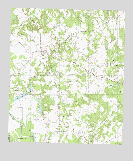
Tennessee Colony, TX USGS Topographic Map
Click on map above to begin viewing in our Map Viewer.

This topographic map contains these locations and features:
Feature Name Type Latitude Longitude GNIS ID View Map
Carroll Lake DamDamN31.7902°W95.8636°1862829View Map
Cedar Lake SloughGutN31.7646°W95.8589°1373022View Map
Clear LakeLakeN31.7576°W95.8483°1354640View Map
HarmonyPopulated PlaceN31.7582°W95.7938°1378417View Map
Highway ChurchChurchN31.8257°W95.8044°1337764View Map
Jimmison Quarter CemeteryCemeteryN31.8110°W95.8472°1890038View Map
Massey LakePopulated PlaceN31.8121°W95.8683°1378648View Map
Providence SchoolSchoolN31.8632°W95.7711°1344605View Map
Saint John ChurchChurchN31.8121°W95.8238°1345929View Map
Snag LakeLakeN31.7560°W95.8725°1889552View Map
Soil Conservation Service Site 1 DamDamN31.8052°W95.8502°1854524View Map
Soil Conservation Service Site 1 ReservoirReservoirN31.8016°W95.8517°1854525View Map
Soil Conservation Service Site 2 DamDamN31.7902°W95.8402°1854522View Map
Soil Conservation Service Site 2 ReservoirReservoirN31.7881°W95.8409°1854523View Map
Spring LakeReservoirN31.7892°W95.8683°1890016View Map
Tennessee ColonyPopulated PlaceN31.8354°W95.8389°1348366View Map
Tennessee Colony Post OfficePost OfficeN31.8346°W95.8409°2732184View Map
Tennessee Colony Volunteer Fire DepartmentBuildingN31.8309°W95.8305°2655344View Map
Texas Department of Criminal Justice George Beto UnitBuildingN31.7547°W95.8237°2738559View Map
Texas Department of Criminal Justice Joe F Gurney Transfer FacilityBuildingN31.7589°W95.8229°2738562View Map
Union ChurchChurchN31.8413°W95.8036°1349050View Map

Note: Coordinates in the location and feature list above are referenced to NAD83 datum.


Copyright (C) 2008-2024 Ryan Niemi / Sunset Dynamics ... All Rights Reserved