TopoQuest Logo
Do you find TopoQuest useful?
Help keep TopoQuest running and adding new maps/features by donating!
Bitcoin:  19c7KJd3qBynnjoSw5npx9KScwjBe4ifkT
Litecoin:  LXs6TkuXGGXo1vDsWCkWVdjQX94eUKd6ui
Home View Maps Find Maps Find Places Resources & Links


Tenalquot Prairie, Washington Topographic Map

USGS Map Title: Tenalquot Prairie, WA
USGS Map MRC: 46122H6
DRG (GeoTIFF) Download: o46122h6.tif


Neighboring USGS Topographic Map Quads:


  Lacey, WA  
47122A7
 

  Nisqually, WA  
47122A6
 

  Fort Lewis, WA  
47122A5
 

  East Olympia, WA  
46122H7
 

  Tenalquot Prairie, WA  
46122H6
 

  McKenna, WA  
46122H5
 

  Bucoda, WA  
46122G7
 

  Vail, WA  
46122G6
 

  Lake Lawrence, WA  
46122G5


Map MRC Location:

N47°
W123°
N47°
W122°
H8 H7 H6 H5 H4 H3 H2 H1
G8 G7 G6 G5 G4 G3 G2 G1
F8 F7 F6 F5 F4 F3 F2 F1
E8 E7 E6 E5 E4 E3 E2 E1
D8 D7 D6 D5 D4 D3 D2 D1
C8 C7 C6 C5 C4 C3 C2 C1
B8 B7 B6 B5 B4 B3 B2 B1
A8 A7 A6 A5 A4 A3 A2 A1
N46°
W123°
N46°
W122°

Tenalquot Prairie, WA USGS 1:24K Topographic Map Preview:
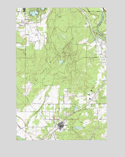
Tenalquot Prairie, WA USGS Topographic Map
Click on map above to begin viewing in our Map Viewer.

This topographic map contains these locations and features:
Feature Name Type Latitude Longitude GNIS ID View Map
Burnham RanchLocaleN46.9173°W122.6479°1503660View Map
Cat LakesLakeN46.9689°W122.6858°1503857View Map
City of RainierCivilN46.8917°W122.6866°2412521View Map
City of YelmCivilN46.9398°W122.6261°2412317View Map
Collins SchoolSchoolN46.9848°W122.7299°1504073View Map
Eaton CreekStreamN46.9923°W122.7268°1504664View Map
Fagan LakeLakeN46.9044°W122.6700°1504798View Map
Fiander LakeLakeN46.9490°W122.6892°1504863View Map
Gehrke LakeLakeN46.8862°W122.6608°1505101View Map
Inman LakeLakeN46.8860°W122.6720°1505740View Map
Lacey Fire District 3 Station 32BuildingN46.9921°W122.7090°2643314View Map
LZ Ranch AirportAirportN46.9731°W122.7363°2443245View Map
McClure LakeLakeN46.9076°W122.6507°1506538View Map
McEnniery LakeLakeN46.9060°W122.6682°1506564View Map
Olympia East DivisionCivilN46.9729°W122.6865°1939586View Map
Oxbow LakeSwampN46.9842°W122.6315°1532916View Map
Oxbow Lake DamDamN46.9832°W122.6312°1532915View Map
RainierPopulated PlaceN46.8882°W122.6885°1507707View Map
Rainier Police DepartmentBuildingN46.8887°W122.6899°2721995View Map
Rainier Post OfficePost OfficeN46.8893°W122.6902°2769207View Map
Rainier Primary SchoolSchoolN46.8832°W122.6928°1515028View Map
Rainier Senior High SchoolSchoolN46.8856°W122.6894°1515029View Map
Rainier TowerLocaleN46.9570°W122.6879°1512841View Map
Southeast Thurston Fire Authority Station 24 RainierBuildingN46.8946°W122.6760°2643973View Map
Southworth Elementary SchoolSchoolN46.9691°W122.6425°1514987View Map
Taylor AirportAirportN46.8980°W122.6680°2443270View Map
Tenalquot PrairieFlatN46.9104°W122.7137°1508939View Map
Thompson CreekStreamN46.9779°W122.6376°1508997View Map
Thurston County Fire Protection District 4BuildingN46.8873°W122.6890°2619479View Map
Yelm CreekStreamN46.9707°W122.6271°1509661View Map
Yelm High School 12SchoolN46.9508°W122.6252°1514989View Map

Note: Coordinates in the location and feature list above are referenced to NAD83 datum.


Copyright (C) 2008-2024 Ryan Niemi / Sunset Dynamics ... All Rights Reserved