TopoQuest Logo
Do you find TopoQuest useful?
Help keep TopoQuest running and adding new maps/features by donating!
Bitcoin:  19c7KJd3qBynnjoSw5npx9KScwjBe4ifkT
Litecoin:  LXs6TkuXGGXo1vDsWCkWVdjQX94eUKd6ui
Home View Maps Find Maps Find Places Resources & Links


Tenabo, Nevada Topographic Map

USGS Map Title: Tenabo, NV
USGS Map MRC: 40116C6
DRG (GeoTIFF) Download: o40116c6.tif


Neighboring USGS Topographic Map Quads:


  Mount Lewis, NV  
40116D7
 

  Mud Spring Gulch, NV  
40116D6
 

  Crescent Valley, NV  
40116D5
 

  Ferris Creek, NV  
40116C7
 

  Tenabo, NV  
40116C6
 

  East of Tenabo, NV  
40116C5
 

  Rocky Pass, NV  
40116B7
 

  Cortez Canyon, NV  
40116B6
 

  Cortez, NV  
40116B5


Map MRC Location:

N41°
W117°
N41°
W116°
H8 H7 H6 H5 H4 H3 H2 H1
G8 G7 G6 G5 G4 G3 G2 G1
F8 F7 F6 F5 F4 F3 F2 F1
E8 E7 E6 E5 E4 E3 E2 E1
D8 D7 D6 D5 D4 D3 D2 D1
C8 C7 C6 C5 C4 C3 C2 C1
B8 B7 B6 B5 B4 B3 B2 B1
A8 A7 A6 A5 A4 A3 A2 A1
N40°
W117°
N40°
W116°

Tenabo, NV USGS 1:24K Topographic Map Preview:
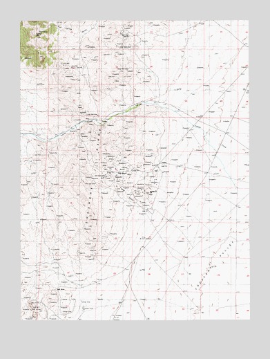
Tenabo, NV USGS Topographic Map
Click on map above to begin viewing in our Map Viewer.

This topographic map contains these locations and features:
Feature Name Type Latitude Longitude GNIS ID View Map
Ajax MineMineN40.3099°W116.6993°853693View Map
Altenburg HillSummitN40.3024°W116.6829°838428View Map
Altenburg Hill MineMineN40.3027°W116.6815°853807View Map
Altenburg MineMineN40.3019°W116.6843°853695View Map
Altenburg Placer MineMineN40.2971°W116.6848°853694View Map
Badger MineMineN40.3502°W116.6987°853745View Map
Blue Eagle MineMineN40.3674°W116.6829°853747View Map
Blue Matrix MineMineN40.3646°W116.7148°853803View Map
Blue Nugget MineMineN40.3413°W116.6876°853744View Map
Blue Rock MineMineN40.3183°W116.7137°853660View Map
Blue Sky MineMineN40.3058°W116.6893°853812View Map
Bridal Vein MineMineN40.3183°W116.7137°853658View Map
Bronco Number Two Placer MineMineN40.3183°W116.7137°853661View Map
Bullion (historical)Populated PlaceN40.3374°W116.6929°846498View Map
Bullion Mining DistrictCivilN40.3183°W116.7137°854825View Map
Bullion MountainSummitN40.3699°W116.7451°839183View Map
Caledonia Placer MineMineN40.3183°W116.7137°853663View Map
Campbell and Young MineMineN40.3183°W116.7137°853662View Map
Color Back MineMineN40.3641°W116.6904°854720View Map
Desert Placers MineMineN40.3183°W116.7137°853664View Map
Dutch Oven MineMineN40.3183°W116.7137°853665View Map
Dutch Oven Placer MineMineN40.3183°W116.7137°853666View Map
Emma Number Two Placer MineMineN40.3183°W116.7137°853667View Map
Empire MineMineN40.3183°W116.7137°853668View Map
Estella Bertrano MineMineN40.3183°W116.7137°853669View Map
Euclid MineMineN40.3183°W116.7137°853670View Map
Exile MineMineN40.3183°W116.7137°853671View Map
Extra MineMineN40.3080°W116.6779°853811View Map
Fairview Placer MineMineN40.3183°W116.7137°853672View Map
Frisbie (historical)Populated PlaceN40.2727°W116.6937°857572View Map
Frisbie Post Office (historical)Post OfficeN40.2727°W116.6937°864752View Map
Gem MineMineN40.3183°W116.7137°853673View Map
Giffen Placer MineMineN40.3183°W116.7137°853674View Map
Gold AcresPopulated PlaceN40.2621°W116.7326°845475View Map
Gold Acres MineMineN40.2571°W116.7451°854465View Map
Gold PanMineN40.3183°W116.7137°853659View Map
Gold Pan MineMineN40.3133°W116.7018°853692View Map
Gold Pan Placer MineMineN40.3183°W116.7137°853675View Map
Gold QuartzPopulated PlaceN40.3108°W116.7004°845479View Map
Gold Quartz MineMineN40.3108°W116.7034°847173View Map
Gold Slug Placer MineMineN40.3183°W116.7137°853676View Map
Grand Prize MineMineN40.3594°W116.7481°853800View Map
Gylding MineMineN40.3177°W116.7006°853691View Map
Gylding Number Two Placer MineMineN40.3183°W116.7137°853677View Map
Hale and May MineMineN40.3183°W116.7137°853678View Map
House Rock MineMineN40.3549°W116.6918°849557View Map
Independence Placer MineMineN40.3183°W116.7137°853679View Map
Jarbidge MineMineN40.3183°W116.7137°853680View Map
Lander (historical)Populated PlaceN40.3330°W116.7065°847387View Map
Lander MineMineN40.3183°W116.7137°853681View Map
Lander Post Office (historical)Post OfficeN40.3330°W116.7065°864421View Map
Little Chief MineMineN40.3355°W116.7087°849558View Map
Little Gem MineMineN40.3071°W116.7098°854721View Map
Little Phoenix MineMineN40.3183°W116.7137°853682View Map
Locust MineMineN40.3183°W116.7137°853683View Map
Locust Placer MineMineN40.3183°W116.7137°853684View Map
Lovie MineMineN40.3574°W116.7287°854516View Map
Lucky Boy MineMineN40.3183°W116.7137°853685View Map
Lucky Boy Placer MineMineN40.3183°W116.7137°853686View Map
Lyon MineMineN40.3183°W116.7137°853687View Map
Marilyn Placer MineMineN40.3183°W116.7137°853721View Map
Mary Ellen Place MineMineN40.3183°W116.7137°853722View Map
Mill GulchValleyN40.3116°W116.6865°842127View Map
Mill Gulch (historical)Populated PlaceN40.3119°W116.6798°846497View Map
Mill Gulch Placer MineMineN40.3116°W116.7020°853688View Map
Mineral Range MineMineN40.3183°W116.7137°853723View Map
Minnesota Placer MineMineN40.3183°W116.7137°853724View Map
New Blue MineMineN40.3694°W116.6959°853802View Map
No Name Number One MineMineN40.3535°W116.6870°853746View Map
Norma Placer MineMineN40.3183°W116.7137°853725View Map
Old Campground MineMineN40.3702°W116.6943°853748View Map
Old Mill MineMineN40.3183°W116.7137°853726View Map
Old Tenabo Placer MineMineN40.3183°W116.7137°853727View Map
Pastime MineMineN40.3183°W116.7137°853728View Map
Phoenix MineMineN40.3149°W116.7043°853690View Map
Plastime Placer MineMineN40.3183°W116.7137°853729View Map
Raleigh MineMineN40.3180°W116.7040°853689View Map
Raleigh School (historical)SchoolN40.2644°W116.7290°858352View Map
Red Hills MineMineN40.3183°W116.7137°853730View Map
Rex Number One Placer MineMineN40.3183°W116.7137°853731View Map
Rex Number Two Placer MineMineN40.3183°W116.7137°853732View Map
Rock SpringSpringN40.3707°W116.7403°843290View Map
Rufan MineMineN40.3191°W116.7398°853799View Map
Sander MineMineN40.3183°W116.7137°853733View Map
Schultes MineMineN40.3183°W116.7137°853734View Map
Silver Gem MineMineN40.3183°W116.7137°853736View Map
Silver Grey MineMineN40.3183°W116.7137°853735View Map
Silver Prize MineMineN40.2758°W116.7112°853808View Map
Silver Sides MineMineN40.3269°W116.7176°853801View Map
Stanley MineMineN40.3183°W116.7137°853737View Map
Starting Point Placer MineMineN40.3183°W116.7137°853738View Map
Steinich MineMineN40.2838°W116.7109°853809View Map
Super-X MineMineN40.3419°W116.6968°853813View Map
TenaboPopulated PlaceN40.3144°W116.6768°844209View Map
Tenabo Post Office (historical)Post OfficeN40.3144°W116.6768°864420View Map
Tomcat MineMineN40.3202°W116.7359°854649View Map
Triplet GulchValleyN40.2955°W116.6837°844410View Map
Triplett Group MinesMineN40.3019°W116.6906°853810View Map
Valley View MineMineN40.3183°W116.7137°853739View Map
Viola MineMineN40.3183°W116.7137°853740View Map
Virginia Placer MineMineN40.3183°W116.7137°853741View Map
Wonder Placer MineMineN40.3183°W116.7137°853742View Map
Yellow Streak Placer MineMineN40.3183°W116.7137°853743View Map

Note: Coordinates in the location and feature list above are referenced to NAD83 datum.


Copyright (C) 2008-2024 Ryan Niemi / Sunset Dynamics ... All Rights Reserved