TopoQuest Logo
Do you find TopoQuest useful?
Help keep TopoQuest running and adding new maps/features by donating!
Bitcoin:  19c7KJd3qBynnjoSw5npx9KScwjBe4ifkT
Litecoin:  LXs6TkuXGGXo1vDsWCkWVdjQX94eUKd6ui
Home View Maps Find Maps Find Places Resources & Links


Tecoma, Nevada Topographic Map

USGS Map Title: Tecoma, NV
USGS Map MRC: 41114C1
DRG (GeoTIFF) Download: o41114c1.tif


Neighboring USGS Topographic Map Quads:


  Twelvemile Ranch, NV  
41114D2
 

  Jackson Spring, NV  
41114D1
 

  Lucin NW, UT  
41113D8
 

  Montello, NV  
41114C2
 

  Tecoma, NV  
41114C1
 

  Lucin, UT  
41113C8
 

  Pilot Peak NW, NV  
41114B2
 

  Patterson Pass, UT  
41114B1
 

  Crater Island NW, UT  
41113B8


Map MRC Location:

N42°
W115°
N42°
W114°
H8 H7 H6 H5 H4 H3 H2 H1
G8 G7 G6 G5 G4 G3 G2 G1
F8 F7 F6 F5 F4 F3 F2 F1
E8 E7 E6 E5 E4 E3 E2 E1
D8 D7 D6 D5 D4 D3 D2 D1
C8 C7 C6 C5 C4 C3 C2 C1
B8 B7 B6 B5 B4 B3 B2 B1
A8 A7 A6 A5 A4 A3 A2 A1
N41°
W115°
N41°
W114°

Tecoma, NV USGS 1:24K Topographic Map Preview:
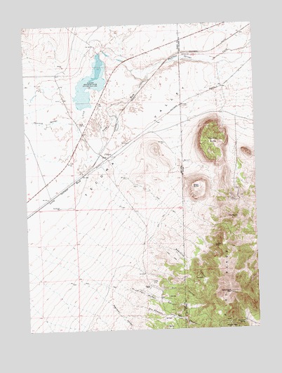
Tecoma, NV USGS Topographic Map
Click on map above to begin viewing in our Map Viewer.

This topographic map contains these locations and features:
Feature Name Type Latitude Longitude GNIS ID View Map
Bald Eagle CanyonValleyN41.2852°W114.0622°850438View Map
Bald Eagle MountainSummitN41.2649°W114.0158°1425250View Map
Black ButteSummitN41.3091°W114.0345°1425652View Map
Buel Post OfficePost OfficeN41.2555°W114.0464°864469View Map
Buell (historical)Populated PlaceN41.2555°W114.0464°848510View Map
Dake ReservoirReservoirN41.3529°W114.0899°857954View Map
Dake Reservoir DamDamN41.3633°W114.0842°863477View Map
East CanyonValleyN41.2683°W114.0556°840260View Map
East CanyonValleyN41.2683°W114.0558°1427669View Map
Fat Woman CanyonValleyN41.2702°W114.0764°1427892View Map
Fat Woman CanyonValleyN41.2852°W114.1170°840423View Map
Governors SpringSpringN41.2522°W114.0088°1428293View Map
Grouse (historical)LocaleN41.3599°W114.0486°850430View Map
Jackson DamDamN41.3627°W114.0386°1429100View Map
Jackson SidingLocaleN41.3619°W114.0445°847126View Map
Loray WashStreamN41.3591°W114.0483°841827View Map
Lucin Mining DistrictCivilN41.2519°W114.0631°856813View Map
Pearson RanchLocaleN41.2674°W114.0595°842762View Map
Quartzite CanyonValleyN41.2838°W114.0539°1431519View Map
Quartzite CanyonValleyN41.3083°W114.0825°843030View Map
Regulator CanyonValleyN41.2816°W114.1203°843192View Map
Rhyolite ButteSummitN41.3266°W114.0303°1431770View Map
Six Shooter CanyonValleyN41.2852°W114.1170°843735View Map
Stockberger WellWellN41.3002°W114.1072°844018View Map
TecomaPopulated PlaceN41.3202°W114.0814°856148View Map
Tecoma Post Office (historical)Post OfficeN41.3202°W114.0814°864618View Map
The NippleSummitN41.2949°W114.0142°1433387View Map
TuttleLocaleN41.2683°W114.0589°844464View Map

Note: Coordinates in the location and feature list above are referenced to NAD83 datum.


Copyright (C) 2008-2024 Ryan Niemi / Sunset Dynamics ... All Rights Reserved