TopoQuest Logo
Do you find TopoQuest useful?
Help keep TopoQuest running and adding new maps/features by donating!
Bitcoin:  19c7KJd3qBynnjoSw5npx9KScwjBe4ifkT
Litecoin:  LXs6TkuXGGXo1vDsWCkWVdjQX94eUKd6ui
Home View Maps Find Maps Find Places Resources & Links


Bloomington, Wisconsin Topographic Map

USGS Map Title: Bloomington, WI
USGS Map MRC: 42090H8
DRG (GeoTIFF) Download: o42090h8.tif


Neighboring USGS Topographic Map Quads:


  Bridgeport, WI  
43091A1
 

  Wauzeka West, WI  
43090A8
 

  Wauzeka East, WI  
43090A7
 

  Brodtville, WI  
42091H1
 

  Bloomington, WI  
42090H8
 

  Mount Hope, WI  
42090H7
 

  Guttenberg, IA  
42091G1
 

  Beetown, WI  
42090G8
 

  Hurricane, WI  
42090G7


Map MRC Location:

N43°
W91°
N43°
W90°
H8 H7 H6 H5 H4 H3 H2 H1
G8 G7 G6 G5 G4 G3 G2 G1
F8 F7 F6 F5 F4 F3 F2 F1
E8 E7 E6 E5 E4 E3 E2 E1
D8 D7 D6 D5 D4 D3 D2 D1
C8 C7 C6 C5 C4 C3 C2 C1
B8 B7 B6 B5 B4 B3 B2 B1
A8 A7 A6 A5 A4 A3 A2 A1
N42°
W91°
N42°
W90°

Bloomington, WI USGS 1:24K Topographic Map Preview:
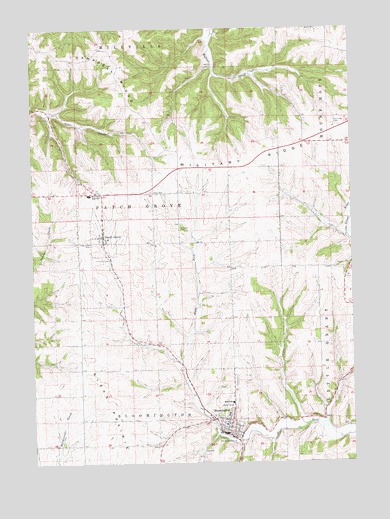
Bloomington, WI USGS Topographic Map
Click on map above to begin viewing in our Map Viewer.

This topographic map contains these locations and features:
Feature Name Type Latitude Longitude GNIS ID View Map
BloomingtonPopulated PlaceN42.8853°W90.9235°1561936View Map
Bloomington Fire DepartmentBuildingN42.8850°W90.9273°2697677View Map
Breezy L FarmsLocaleN42.9672°W90.8961°2709184View Map
Campbell RidgeRidgeN42.9942°W90.9962°1562686View Map
Finn QuarryMineN42.9550°W90.9806°2633679View Map
Hermitage CemeteryCemeteryN42.9722°W90.8804°1566323View Map
Mac D FarmsLocaleN42.9286°W90.9381°2709280View Map
Maryline FarmLocaleN42.9119°W90.9656°2709281View Map
Military RidgeRidgeN42.9628°W90.9110°1569461View Map
Moravits FarmLocaleN42.9444°W90.9408°2709278View Map
Patch GrovePopulated PlaceN42.9403°W90.9721°1571075View Map
Patch Grove CemeteryCemeteryN42.9380°W90.9771°1571076View Map
Patch Grove Fire DepartmentBuildingN42.9414°W90.9729°2698184View Map
River Ridge Elementary SchoolSchoolN42.9520°W90.9772°2715745View Map
River Ridge High SchoolSchoolN42.9520°W90.9772°1576509View Map
River Ridge Middle SchoolSchoolN42.8923°W90.9226°1840534View Map
Saint Johns CemeteryCemeteryN42.9425°W90.9423°1573029View Map
Saint Mary's SchoolSchoolN42.8885°W90.9243°2715676View Map
Town of Patch GroveCivilN42.9492°W90.9624°1583900View Map
Union CemeteryCemeteryN42.9533°W90.9532°1575865View Map
Village of BloomingtonCivilN42.8929°W90.9260°1582835View Map
Village of Patch GroveCivilN42.9404°W90.9723°1583899View Map
West Grant Rescue SquadBuildingN42.8838°W90.9236°2698281View Map
Willowbrook FarmLocaleN42.9164°W90.9669°2709277View Map

Note: Coordinates in the location and feature list above are referenced to NAD83 datum.


Copyright (C) 2008-2024 Ryan Niemi / Sunset Dynamics ... All Rights Reserved