TopoQuest Logo
Do you find TopoQuest useful?
Help keep TopoQuest running and adding new maps/features by donating!
Bitcoin:  19c7KJd3qBynnjoSw5npx9KScwjBe4ifkT
Litecoin:  LXs6TkuXGGXo1vDsWCkWVdjQX94eUKd6ui
Home View Maps Find Maps Find Places Resources & Links


Taylor SE, Nebraska Topographic Map

USGS Map Title: Taylor SE, NE
USGS Map MRC: 41099G3
DRG (GeoTIFF) Download: o41099g3.tif


Neighboring USGS Topographic Map Quads:


  Taylor NW, NE  
41099H4
 

  Taylor NE, NE  
41099H3
 

  Burwell NW, NE  
41099H2
 

  Taylor, NE  
41099G4
 

  Taylor SE, NE  
41099G3
 

  Burwell, NE  
41099G2
 

  Sargent West, NE  
41099F4
 

  Sargent East, NE  
41099F3
 

  Comstock NW, NE  
41099F2


Map MRC Location:

N42°
W100°
N42°
W99°
H8 H7 H6 H5 H4 H3 H2 H1
G8 G7 G6 G5 G4 G3 G2 G1
F8 F7 F6 F5 F4 F3 F2 F1
E8 E7 E6 E5 E4 E3 E2 E1
D8 D7 D6 D5 D4 D3 D2 D1
C8 C7 C6 C5 C4 C3 C2 C1
B8 B7 B6 B5 B4 B3 B2 B1
A8 A7 A6 A5 A4 A3 A2 A1
N41°
W100°
N41°
W99°

Taylor SE, NE USGS 1:24K Topographic Map Preview:
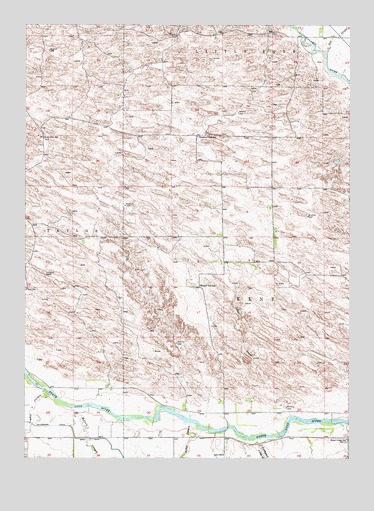
Taylor SE, NE USGS Topographic Map
Click on map above to begin viewing in our Map Viewer.

This topographic map contains these locations and features:
Feature Name Type Latitude Longitude GNIS ID View Map
Aggies AcresPopulated PlaceN41.8672°W99.2676°1845137View Map
Bohys CanyonValleyN41.7583°W99.3051°827553View Map
Bromwick CanyonValleyN41.7556°W99.2829°827669View Map
Calamus ReservoirReservoirN41.8699°W99.2588°837299View Map
Cedar CreekStreamN41.7575°W99.2765°827990View Map
Dry CreekStreamN41.8669°W99.2593°828832View Map
Kent (historical)Populated PlaceN41.7556°W99.3087°1845148View Map
Kent Diversion Dam State Wildlife Management AreaParkN41.7583°W99.2670°1845060View Map
Kent Post Office (historical)Post OfficeN41.7556°W99.3087°1845147View Map
Kent SchoolSchoolN41.7508°W99.2973°830480View Map
Leydell CanyonValleyN41.7644°W99.3573°830695View Map
Lone Star SchoolSchoolN41.8425°W99.3679°830843View Map
McCord CanyonValleyN41.7644°W99.3512°831121View Map
Mikes MeadowsPopulated PlaceN41.8667°W99.2670°1845138View Map
Nunda Shoal CampgroundLocaleN41.8658°W99.2698°1845061View Map
Pleasant View SchoolSchoolN41.8428°W99.3084°832263View Map
Round Hill SchoolSchoolN41.7997°W99.3068°832741View Map
Township of KentCivilN41.7833°W99.2754°1845176View Map
Township of Little YorkCivilN41.8717°W99.2796°1845174View Map

Note: Coordinates in the location and feature list above are referenced to NAD83 datum.


Copyright (C) 2008-2024 Ryan Niemi / Sunset Dynamics ... All Rights Reserved