TopoQuest Logo
Do you find TopoQuest useful?
Help keep TopoQuest running and adding new maps/features by donating!
Bitcoin:  19c7KJd3qBynnjoSw5npx9KScwjBe4ifkT
Litecoin:  LXs6TkuXGGXo1vDsWCkWVdjQX94eUKd6ui
Home View Maps Find Maps Find Places Resources & Links


Bloomfield North, Iowa Topographic Map

USGS Map Title: Bloomfield North, IA
USGS Map MRC: 40092G4
DRG (GeoTIFF) Download: o40092g4.tif


Neighboring USGS Topographic Map Quads:


  Blakesburg NE, IA  
40092H5
 

  Ottumwa South, IA  
40092H4
 

  Agency, IA  
40092H3
 

  Paris, IA  
40092G5
 

  Bloomfield North, IA  
40092G4
 

  Floris, IA  
40092G3
 

  West Grove, IA  
40092F5
 

  Bloomfield South, IA  
40092F4
 

  Pulaski, IA  
40092F3


Map MRC Location:

N41°
W93°
N41°
W92°
H8 H7 H6 H5 H4 H3 H2 H1
G8 G7 G6 G5 G4 G3 G2 G1
F8 F7 F6 F5 F4 F3 F2 F1
E8 E7 E6 E5 E4 E3 E2 E1
D8 D7 D6 D5 D4 D3 D2 D1
C8 C7 C6 C5 C4 C3 C2 C1
B8 B7 B6 B5 B4 B3 B2 B1
A8 A7 A6 A5 A4 A3 A2 A1
N40°
W93°
N40°
W92°

Bloomfield North, IA USGS 1:24K Topographic Map Preview:
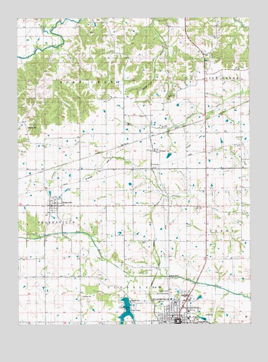
Bloomfield North, IA USGS Topographic Map
Click on map above to begin viewing in our Map Viewer.

This topographic map contains these locations and features:
Feature Name Type Latitude Longitude GNIS ID View Map
BelknapPopulated PlaceN40.8206°W92.4263°454489View Map
Belknap (historical)LocaleN40.8195°W92.4266°1976032View Map
Belknap Post Office (historical)Post OfficeN40.8206°W92.4263°1976031View Map
BloomfieldPopulated PlaceN40.7517°W92.4149°454700View Map
Bloomfield Care CenterHospitalN40.7600°W92.4180°1976060View Map
Bloomfield City ParkParkN40.7525°W92.4046°1976007View Map
Bloomfield Country ClubLocaleN40.7528°W92.3988°1976059View Map
Bloomfield Dental Association CenterHospitalN40.7506°W92.4224°1976069View Map
Bloomfield Foot and Ankle ClinicHospitalN40.7509°W92.4210°1976065View Map
Bloomfield Police DepartmentBuildingN40.7511°W92.4141°1976056View Map
Bloomfield Post OfficePost OfficeN40.7517°W92.4155°1976052View Map
Bloomfield Public LibraryBuildingN40.7520°W92.4169°1976057View Map
Bloomfield SpeedwayLocaleN40.7514°W92.4294°1976035View Map
Bloomfield Water PlantLocaleN40.7594°W92.4400°2728257View Map
Breeding CemeteryCemeteryN40.8303°W92.4951°454813View Map
Cammack CemeteryCemeteryN40.7611°W92.4666°455100View Map
Chequist Post Office (historical)Post OfficeN40.8278°W92.3794°1976029View Map
Christian ChurchChurchN40.7525°W92.4180°1976074View Map
Church of the NazareneChurchN40.7525°W92.4146°1976073View Map
City of DrakesvilleCivilN40.7984°W92.4814°2394561View Map
Davis County CourthouseBuildingN40.7511°W92.4144°1976079View Map
Davis County Elementary SchoolSchoolN40.7551°W92.4080°1976081View Map
Davis County FairgroundsLocaleN40.7528°W92.4307°1976049View Map
Davis County High SchoolSchoolN40.7524°W92.4086°1976080View Map
Davis County Historical MuseumBuildingN40.7506°W92.4141°1976050View Map
Davis County Home and CommunityHospitalN40.7506°W92.4224°1976068View Map
Davis County HospitalHospitalN40.7589°W92.4157°1976063View Map
Davis County Middle SchoolSchoolN40.7551°W92.4092°2719729View Map
Davis County Sheriff's OfficeBuildingN40.7508°W92.4160°1976055View Map
Davis County Welcome CenterBuildingN40.7539°W92.4141°1976053View Map
DrakesvillePopulated PlaceN40.7984°W92.4816°456008View Map
Drakesville (historical)LocaleN40.8000°W92.4799°1976104View Map
Drakesville CemeteryCemeteryN40.7947°W92.4850°456009View Map
Drakesville ParkParkN40.8022°W92.4799°1976105View Map
Drakesville Post OfficePost OfficeN40.7984°W92.4816°1976102View Map
Drakesville Volunteer Fire DepartmentBuildingN40.7990°W92.4833°1976103View Map
Dunnville (historical)Populated PlaceN40.8278°W92.3794°1976030View Map
Dunnville CemeteryCemeteryN40.8229°W92.3796°456069View Map
Dunnville ChurchChurchN40.8261°W92.3791°456070View Map
First Baptist ChurchChurchN40.7556°W92.4041°1976076View Map
Friends Residential CareHospitalN40.7578°W92.4196°1976061View Map
Gilfillan Memorial ClinicHospitalN40.7509°W92.4210°1976066View Map
Harbour CemeteryCemeteryN40.8316°W92.4418°457241View Map
Harbour Post Office (historical)Post OfficeN40.8278°W92.4419°1976028View Map
Hickory Knoll SchoolSchoolN40.7625°W92.4202°1823300View Map
Isaac Mason Historical MarkerParkN40.7947°W92.4857°1976106View Map
Kingdom CemeteryCemeteryN40.8432°W92.4199°458087View Map
KXOF-FM (Bloomfield)TowerN40.7784°W92.3969°463688View Map
Lake FisherReservoirN40.7551°W92.4425°461470View Map
Lake Fisher ParkParkN40.7564°W92.4446°1823301View Map
Lester CemeteryCemeteryN40.7837°W92.4337°458295View Map
Lewiston Post Office (historical)Post OfficeN40.7839°W92.4288°1976014View Map
Midway ChurchChurchN40.8597°W92.3977°459070View Map
Odd Fellows CemeteryCemeteryN40.7619°W92.4119°1823299View Map
Osteopathic Medical CenterHospitalN40.7506°W92.4224°1976067View Map
Pleasant View (historical)Populated PlaceN40.8253°W92.3794°465457View Map
Roland CemeteryCemeteryN40.8334°W92.4419°1976151View Map
Rudd CemeteryCemeteryN40.8625°W92.4974°1976150View Map
Sparks Medical ClinicHospitalN40.7570°W92.4157°1976062View Map
Stogdill Chiropractic CenterHospitalN40.7520°W92.4141°1976064View Map
Swinney CemeteryCemeteryN40.8334°W92.3780°1976145View Map
Tabernacle Baptist ChurchChurchN40.7520°W92.4224°1976071View Map
Township of DrakesvilleCivilN40.7932°W92.4901°467742View Map
Township of Soap CreekCivilN40.8571°W92.4659°468724View Map
United Methodist ChurchChurchN40.7542°W92.4105°1976070View Map
United Methodist ChurchChurchN40.7984°W92.4816°1976101View Map
Word of Life FellowshipChurchN40.7514°W92.4202°1976072View Map

Note: Coordinates in the location and feature list above are referenced to NAD83 datum.


Copyright (C) 2008-2024 Ryan Niemi / Sunset Dynamics ... All Rights Reserved