TopoQuest Logo
Do you find TopoQuest useful?
Help keep TopoQuest running and adding new maps/features by donating!
Bitcoin:  19c7KJd3qBynnjoSw5npx9KScwjBe4ifkT
Litecoin:  LXs6TkuXGGXo1vDsWCkWVdjQX94eUKd6ui
Home View Maps Find Maps Find Places Resources & Links


Tamolitch Falls, Oregon Topographic Map

USGS Map Title: Tamolitch Falls, OR
USGS Map MRC: 44122C1
DRG (GeoTIFF) Download: o44122c1.tif


Neighboring USGS Topographic Map Quads:


  Harter Mountain, OR  
44122D2
 

  Echo Mountain, OR  
44122D1
 

  Santiam Junction, OR  
44121D8
 

  Carpenter Mountain, OR  
44122C2
 

  Tamolitch Falls, OR  
44122C1
 

  Clear Lake, OR  
44121C8
 

  McKenzie Bridge, OR  
44122B2
 

  Belknap Springs, OR  
44122B1
 

  Linton Lake, OR  
44121B8


Map MRC Location:

N45°
W123°
N45°
W122°
H8 H7 H6 H5 H4 H3 H2 H1
G8 G7 G6 G5 G4 G3 G2 G1
F8 F7 F6 F5 F4 F3 F2 F1
E8 E7 E6 E5 E4 E3 E2 E1
D8 D7 D6 D5 D4 D3 D2 D1
C8 C7 C6 C5 C4 C3 C2 C1
B8 B7 B6 B5 B4 B3 B2 B1
A8 A7 A6 A5 A4 A3 A2 A1
N44°
W123°
N44°
W122°

Tamolitch Falls, OR USGS 1:24K Topographic Map Preview:
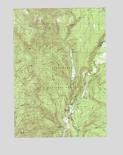
Tamolitch Falls, OR USGS Topographic Map
Click on map above to begin viewing in our Map Viewer.

This topographic map contains these locations and features:
Feature Name Type Latitude Longitude GNIS ID View Map
Anderson CreekStreamN44.2610°W122.0451°1116930View Map
Beaver MarshSwampN44.3372°W122.0007°1117451View Map
Bobby CreekStreamN44.2887°W122.0331°1130644View Map
Browder CreekStreamN44.3410°W122.0551°1118120View Map
Browder RidgeRidgeN44.3710°W122.1040°1138662View Map
Browder Ridge TrailTrailN44.3632°W122.0717°1138663View Map
Brush CreekStreamN44.3132°W122.1228°1118149View Map
Budworm CreekStreamN44.2579°W122.0628°1118255View Map
Bunchgrass CreekStreamN44.3048°W122.0481°1118310View Map
Bunchgrass MountainSummitN44.3190°W122.0995°1136105View Map
Carmen CreekStreamN44.2782°W122.0451°1160905View Map
Carmen Diversion DamDamN44.3401°W122.0026°1158671View Map
Carmen ReservoirReservoirN44.3395°W122.0025°1158670View Map
Carpenter CreekStreamN44.2818°W122.0976°1118624View Map
Conroy CreekStreamN44.2918°W122.1106°1119211View Map
County CreekStreamN44.2782°W122.0931°1119394View Map
Fritz CreekStreamN44.2668°W122.0720°1121002View Map
Gate CreekStreamN44.3618°W122.0417°1121076View Map
Ice Cap Creek Recreation SiteLocaleN44.3429°W122.0017°1162250View Map
Kink CreekStreamN44.2912°W122.0334°1122773View Map
Koosah FallsFallsN44.3440°W122.0006°1122837View Map
Lakes End CampgroundLocaleN44.3320°W122.0473°2754356View Map
Olallie CreekStreamN44.2571°W122.0412°1135814View Map
Olallie Creek Campground Boat RampLocaleN44.2506°W122.0408°2668185View Map
Olallie Recreation SiteLocaleN44.2568°W122.0401°1162207View Map
Payne CreekStreamN44.2873°W122.0345°1130645View Map
Smith DamDamN44.3068°W122.0456°1130643View Map
Smith Prairie TrailTrailN44.3357°W122.0340°1149758View Map
Smith ReservoirReservoirN44.3175°W122.0461°1130642View Map
Smith Reservoir Boat RampLocaleN44.3148°W122.0427°2699918View Map
Smith RiverStreamN44.2729°W122.0495°1149764View Map
Sweetwater CreekStreamN44.2785°W122.0456°1127837View Map
Tamolitch FallsFallsN44.3118°W122.0262°1127881View Map
Trail Bridge DamDamN44.2682°W122.0495°1131601View Map
Trail Bridge Recreation SiteLocaleN44.2790°W122.0512°1162206View Map
Trail Bridge ReservoirReservoirN44.2775°W122.0479°1158852View Map
Trailbridge Campground Boat RampLocaleN44.2784°W122.0500°2699919View Map
Wildcat CreekStreamN44.3493°W122.0806°1802964View Map
Wildcat MountainSummitN44.3362°W122.1087°1129066View Map
Wildcat Mountain Research AreaAreaN44.3443°W122.1095°1162208View Map

Note: Coordinates in the location and feature list above are referenced to NAD83 datum.


Copyright (C) 2008-2024 Ryan Niemi / Sunset Dynamics ... All Rights Reserved