TopoQuest Logo
Do you find TopoQuest useful?
Help keep TopoQuest running and adding new maps/features by donating!
Bitcoin:  19c7KJd3qBynnjoSw5npx9KScwjBe4ifkT
Litecoin:  LXs6TkuXGGXo1vDsWCkWVdjQX94eUKd6ui
Home View Maps Find Maps Find Places Resources & Links


Talent, Oregon Topographic Map

USGS Map Title: Talent, OR
USGS Map MRC: 42122B7
DRG (GeoTIFF) Download: o42122b7.tif


Neighboring USGS Topographic Map Quads:


  Medford West, OR  
42122C8
 

  Medford East, OR  
42122C7
 

  Rio Canyon, OR  
42122C6
 

  Sterling Creek, OR  
42122B8
 

  Talent, OR  
42122B7
 

  Ashland, OR  
42122B6
 

  Dutchman Peak, OR  
42122A8
 

  Siskiyou Peak, OR  
42122A7
 

  Mount Ashland, OR  
42122A6


Map MRC Location:

N43°
W123°
N43°
W122°
H8 H7 H6 H5 H4 H3 H2 H1
G8 G7 G6 G5 G4 G3 G2 G1
F8 F7 F6 F5 F4 F3 F2 F1
E8 E7 E6 E5 E4 E3 E2 E1
D8 D7 D6 D5 D4 D3 D2 D1
C8 C7 C6 C5 C4 C3 C2 C1
B8 B7 B6 B5 B4 B3 B2 B1
A8 A7 A6 A5 A4 A3 A2 A1
N42°
W123°
N42°
W122°

Talent, OR USGS 1:24K Topographic Map Preview:
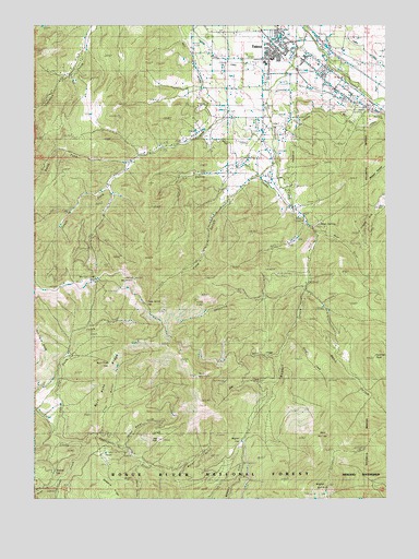
Talent, OR USGS Topographic Map
Click on map above to begin viewing in our Map Viewer.

This topographic map contains these locations and features:
Feature Name Type Latitude Longitude GNIS ID View Map
Arrastra CreekStreamN42.1840°W122.7800°1137303View Map
Ashland MineMineN42.2040°W122.7517°1137321View Map
Bald MountainSummitN42.1576°W122.8184°1137447View Map
Basin CreekStreamN42.1626°W122.7900°1137554View Map
Bear GulchValleyN42.1790°W122.7803°1154728View Map
Bear WallowSlopeN42.1415°W122.7739°1137765View Map
Brickpile RanchLocaleN42.1418°W122.8561°1138600View Map
Bull Pine GapGapN42.1629°W122.8506°1138911View Map
Bull Pine RidgeRidgeN42.1562°W122.8548°1138912View Map
Camelot TheatreBuildingN42.2453°W122.7869°2699173View Map
Carter OrchardsLocaleN42.2314°W122.7983°2563663View Map
City of TalentCivilN42.2404°W122.7807°2412031View Map
Cygnet FarmLocaleN42.2239°W122.7928°2563670View Map
Duncan GapGapN42.1307°W122.8717°1141402View Map
First Water GulchValleyN42.1443°W122.8536°1158234View Map
Frazier GulchValleyN42.2012°W122.8623°1162388View Map
Frederick (historical)LocaleN42.2282°W122.7595°1166460View Map
Frederick LateralCanalN42.2229°W122.7825°1142435View Map
Glade CreekStreamN42.1396°W122.8614°1142757View Map
Goose CreekStreamN42.1674°W122.7859°1134701View Map
Holton CreekStreamN42.2137°W122.8039°1154731View Map
Hope SpringSpringN42.1783°W122.7747°1154729View Map
Horn GulchValleyN42.1712°W122.7823°1143734View Map
Jeffery CreekStreamN42.2493°W122.7789°1155082View Map
Kerby ReservoirReservoirN42.2106°W122.8158°1134702View Map
Meyer OrchardsLocaleN42.2375°W122.8050°2563669View Map
Mule GulchValleyN42.1276°W122.8725°1146634View Map
Myer CreekStreamN42.2326°W122.7595°1146123View Map
North Fork Anderson CreekStreamN42.2135°W122.8453°1146902View Map
Oak FlatFlatN42.1407°W122.8317°1154727View Map
Packard GulchValleyN42.2249°W122.7928°1154732View Map
Panther PeakSummitN42.1620°W122.7555°1134699View Map
Phipps GulchValleyN42.2387°W122.8609°1154733View Map
Point MountainSummitN42.1828°W122.8404°1147819View Map
Pollard SpringSpringN42.2277°W122.7569°1154726View Map
Rail GulchValleyN42.1999°W122.7803°1154730View Map
Second Water GulchValleyN42.1393°W122.8453°1149210View Map
Section Line GapGapN42.1843°W122.8573°1149216View Map
Skunk GulchValleyN42.1332°W122.8411°1149646View Map
South Fork Anderson CreekStreamN42.2135°W122.8453°1149921View Map
Stearn CemeteryCemeteryN42.2250°W122.7977°1150383View Map
TalentPopulated PlaceN42.2457°W122.7886°1150844View Map
Talent Branch LibraryBuildingN42.2448°W122.7885°2699862View Map
Talent City HallBuildingN42.2440°W122.7894°2699863View Map
Talent Elementary SchoolSchoolN42.2410°W122.7919°2440093View Map
Talent Historical Society and MuseumBuildingN42.2447°W122.7886°2699864View Map
Talent Middle SchoolSchoolN42.2399°W122.7943°1162387View Map
Talent Municipal CourtBuildingN42.2440°W122.7894°2699865View Map
Talent Park and RideLocaleN42.2471°W122.7887°2699768View Map
Talent Police DepartmentBuildingN42.2386°W122.7782°2737729View Map
Talent Post OfficePost OfficeN42.2431°W122.7881°1166030View Map
Talent Public Works Department OfficeBuildingN42.2486°W122.7859°2699866View Map
Upper West LateralCanalN42.2146°W122.8053°1151710View Map
Wagner CreekStreamN42.2496°W122.7806°1151799View Map
Wagner GapGapN42.1393°W122.8028°1151800View Map
Water GulchValleyN42.1310°W122.8264°1151936View Map
West LateralCanalN42.2410°W122.8217°1152132View Map
Wildcat CanyonValleyN42.2126°W122.7511°1134703View Map
Yank GulchValleyN42.2079°W122.8028°1152693View Map
Yank Gulch GapGapN42.1768°W122.8367°1134700View Map

Note: Coordinates in the location and feature list above are referenced to NAD83 datum.


Copyright (C) 2008-2024 Ryan Niemi / Sunset Dynamics ... All Rights Reserved