TopoQuest Logo
Do you find TopoQuest useful?
Help keep TopoQuest running and adding new maps/features by donating!
Bitcoin:  19c7KJd3qBynnjoSw5npx9KScwjBe4ifkT
Litecoin:  LXs6TkuXGGXo1vDsWCkWVdjQX94eUKd6ui
Home View Maps Find Maps Find Places Resources & Links


Tajiguas, California Topographic Map

USGS Map Title: Tajiguas, CA
USGS Map MRC: 34120D1
DRG (GeoTIFF) Download: o34120d1.tif


Neighboring USGS Topographic Map Quads:


  Solvang, CA  
34120E2
 

  Santa Ynez, CA  
34120E1
 

  Lake Cachuma, CA  
34119E8
 

  Gaviota, CA  
34120D2
 

  Tajiguas, CA  
34120D1
 

  Dos Pueblos Canyon, CA  
34119D8


Map MRC Location:

N35°
W121°
N35°
W120°
H8 H7 H6 H5 H4 H3 H2 H1
G8 G7 G6 G5 G4 G3 G2 G1
F8 F7 F6 F5 F4 F3 F2 F1
E8 E7 E6 E5 E4 E3 E2 E1
D8 D7 D6 D5 D4 D3 D2 D1
C8 C7 C6 C5 C4 C3 C2 C1
B8 B7 B6 B5 B4 B3 B2 B1
A8 A7 A6 A5 A4 A3 A2 A1
N34°
W121°
N34°
W120°

Tajiguas, CA USGS 1:24K Topographic Map Preview:
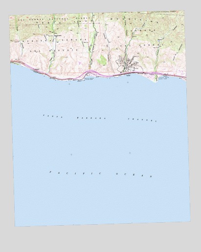
Tajiguas, CA USGS Topographic Map
Click on map above to begin viewing in our Map Viewer.

This topographic map contains these locations and features:
Feature Name Type Latitude Longitude GNIS ID View Map
Aguajito CanyonValleyN34.4764°W120.0696°238455View Map
Ahwin (historical)Populated PlaceN34.4603°W120.0243°1816965View Map
Arroyo QuemadoValleyN34.4700°W120.1190°238761View Map
Cañada de la DestiladeraValleyN34.4619°W120.0085°240139View Map
Cañada del CapitanValleyN34.4578°W120.0221°240157View Map
Cañada del CorralCivilN34.4847°W120.0338°240162View Map
Cañada Del CorralValleyN34.4625°W120.0449°240163View Map
Cañada Del RefugioValleyN34.4630°W120.0696°240168View Map
Cañada del VenaditoValleyN34.4617°W120.0529°240171View Map
CapitanPopulated PlaceN34.4633°W120.0432°1660435View Map
El Capitan BeachBeachN34.4597°W120.0274°1702033View Map
El Capitan CreekStreamN34.4578°W120.0224°1816963View Map
El Capitán State BeachParkN34.4614°W120.0196°241880View Map
Exxon Santa Ynez Vessel HeliportAirportN34.3883°W120.1018°1653974View Map
Las Flores CanyonValleyN34.4794°W120.0424°244609View Map
Las Llagas CanyonValleyN34.4605°W120.0004°271980View Map
Leon CanyonValleyN34.4794°W120.0951°244743View Map
Orella (historical)Populated PlaceN34.4625°W120.0510°1702036View Map
Platform OCS P-0188 Hondo HeliportAirportN34.3905°W120.1224°1653973View Map
Refugio BeachBeachN34.4628°W120.0701°1702037View Map
Refugio State BeachParkN34.4622°W120.0724°248114View Map
TajiguasPopulated PlaceN34.4667°W120.1085°1661547View Map
Tajiguas CreekStreamN34.4636°W120.1010°250236View Map
Tajiguas RanchLocaleN34.4864°W120.0926°250237View Map

Note: Coordinates in the location and feature list above are referenced to NAD83 datum.


Copyright (C) 2008-2024 Ryan Niemi / Sunset Dynamics ... All Rights Reserved