TopoQuest Logo
Do you find TopoQuest useful?
Help keep TopoQuest running and adding new maps/features by donating!
Bitcoin:  19c7KJd3qBynnjoSw5npx9KScwjBe4ifkT
Litecoin:  LXs6TkuXGGXo1vDsWCkWVdjQX94eUKd6ui
Home View Maps Find Maps Find Places Resources & Links


Tahkenitch Creek, Oregon Topographic Map

USGS Map Title: Tahkenitch Creek, OR
USGS Map MRC: 43124G2
DRG (GeoTIFF) Download: o43124g2.tif


Neighboring USGS Topographic Map Quads:


  Goose Pasture, OR  
43124H2
 

  Florence, OR  
43124H1


  Tahkenitch Creek, OR  
43124G2
 

  Fivemile Creek, OR  
43124G1


  Winchester Bay, OR  
43124F2
 

  Reedsport, OR  
43124F1


Map MRC Location:

N44°
W125°
N44°
W124°
H8 H7 H6 H5 H4 H3 H2 H1
G8 G7 G6 G5 G4 G3 G2 G1
F8 F7 F6 F5 F4 F3 F2 F1
E8 E7 E6 E5 E4 E3 E2 E1
D8 D7 D6 D5 D4 D3 D2 D1
C8 C7 C6 C5 C4 C3 C2 C1
B8 B7 B6 B5 B4 B3 B2 B1
A8 A7 A6 A5 A4 A3 A2 A1
N43°
W125°
N43°
W124°

Tahkenitch Creek, OR USGS 1:24K Topographic Map Preview:
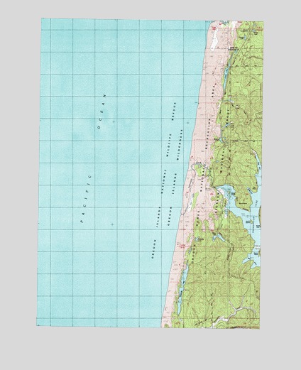
Tahkenitch Creek, OR USGS Topographic Map
Click on map above to begin viewing in our Map Viewer.

This topographic map contains these locations and features:
Feature Name Type Latitude Longitude GNIS ID View Map
Bass ArmsBayN43.7785°W124.1298°1134955View Map
Burnt PointCapeN43.7971°W124.1318°1153515View Map
Butterfly LakeLakeN43.7860°W124.1621°1134956View Map
Carter Dunes TrailTrailN43.8576°W124.1529°1155990View Map
Carter LakeLakeN43.8531°W124.1466°1139405View Map
Carter Lake Boat RampLocaleN43.8565°W124.1448°1155993View Map
Carter Lake CreekStreamN43.8415°W124.1429°1134958View Map
Carter Lake Recreation SiteLocaleN43.8565°W124.1473°1155989View Map
Clay PointCapeN43.8054°W124.1290°1153512View Map
Crown Z LakeLakeN43.8288°W124.1492°1153409View Map
Crown Zellerback CampgroundLocaleN43.8321°W124.1482°1156008View Map
Deer ArmBayN43.8137°W124.1276°1153422View Map
East Carter Campground (historical)LocaleN43.8565°W124.1446°1167164View Map
East Cater Boat RampLocaleN43.8565°W124.1448°2668347View Map
Elbow LakeLakeN43.7873°W124.1498°1141716View Map
Elbow Lake CampgroundLocaleN43.7873°W124.1526°1162215View Map
Elbow Lake CreekStreamN43.7976°W124.1471°1153408View Map
Erhart LakeLakeN43.8710°W124.1317°1141886View Map
Georgia LakeLakeN43.8732°W124.1310°1153518View Map
Home PointCapeN43.7776°W124.1262°1153510View Map
Jewitt IslandIslandN43.7935°W124.1318°1134957View Map
KrollLocaleN43.7923°W124.1259°1144709View Map
Kroll Post Office (historical)Post OfficeN43.7923°W124.1259°1165497View Map
Loon LakeLakeN43.8681°W124.1365°1145486View Map
Lost LakeLakeN43.8324°W124.1460°1153410View Map
Lost Lake Campground (historical)LocaleN43.8318°W124.1484°1162217View Map
Oregon Dunes Recreation SiteLocaleN43.8318°W124.1498°1155991View Map
Overlook Loop TrailTrailN43.8240°W124.1654°1156007View Map
Perkins LakeLakeN43.8263°W124.1493°1153411View Map
Shag ArmBayN43.8054°W124.1332°1162216View Map
Siltcoos LookoutLocaleN43.8701°W124.1251°1149478View Map
Siltcoos Recreation SiteLocaleN43.8743°W124.1435°1149477View Map
Siltcoos RiverStreamN43.8737°W124.1540°1149479View Map
Smith River Ranger Station (historical)BuildingN43.8001°W124.1471°1149768View Map
Spring PointCapeN43.7998°W124.1268°1153438View Map
Tahkenitch Boat LandingLocaleN43.8040°W124.1477°2668545View Map
Tahkenitch Boat RampLocaleN43.7997°W124.1466°1156004View Map
Tahkenitch CreekStreamN43.8148°W124.1662°1150838View Map
Tahkenitch Lake DamDamN43.8073°W124.1523°1155509View Map
Tahkenitch Landing Recreation SiteLocaleN43.8010°W124.1484°1156014View Map
Tahkenitch Recreation SiteLocaleN43.7971°W124.1479°1150840View Map
Tahkenitch TrailTrailN43.7907°W124.1596°1156011View Map
Threemile LakeLakeN43.7663°W124.1698°1151193View Map
Threemile Lake TrailTrailN43.7851°W124.1596°1156038View Map
W D Hull Mill (historical)LocaleN43.7854°W124.1259°1166291View Map
Waxmyrtle TrailTrailN43.8712°W124.1385°1155967View Map
Weed IslandIslandN43.8046°W124.1443°1153514View Map

Note: Coordinates in the location and feature list above are referenced to NAD83 datum.


Copyright (C) 2008-2024 Ryan Niemi / Sunset Dynamics ... All Rights Reserved