TopoQuest Logo
Do you find TopoQuest useful?
Help keep TopoQuest running and adding new maps/features by donating!
Bitcoin:  19c7KJd3qBynnjoSw5npx9KScwjBe4ifkT
Litecoin:  LXs6TkuXGGXo1vDsWCkWVdjQX94eUKd6ui
Home View Maps Find Maps Find Places Resources & Links


Summertown, Tennessee Topographic Map

USGS Map Title: Summertown, TN
USGS Map MRC: 35087D3
DRG (GeoTIFF) Download: o35087d3.tif


Neighboring USGS Topographic Map Quads:


  Gordonsburg, TN  
35087E4
 

  Mount Joy, TN  
35087E3
 

  Mount Pleasant, TN  
35087E2
 

  Henryville, TN  
35087D4
 

  Summertown, TN  
35087D3
 

  Sandy Hook, TN  
35087D2
 

  Deerfield, TN  
35087C4
 

  Ethridge, TN  
35087C3
 

  Campbellsville, TN  
35087C2


Map MRC Location:

N36°
W88°
N36°
W87°
H8 H7 H6 H5 H4 H3 H2 H1
G8 G7 G6 G5 G4 G3 G2 G1
F8 F7 F6 F5 F4 F3 F2 F1
E8 E7 E6 E5 E4 E3 E2 E1
D8 D7 D6 D5 D4 D3 D2 D1
C8 C7 C6 C5 C4 C3 C2 C1
B8 B7 B6 B5 B4 B3 B2 B1
A8 A7 A6 A5 A4 A3 A2 A1
N35°
W88°
N35°
W87°

Summertown, TN USGS 1:24K Topographic Map Preview:
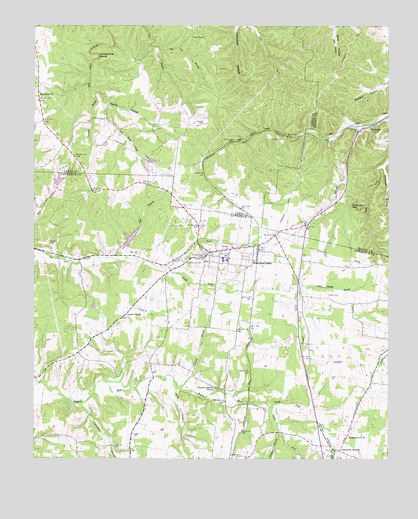
Summertown, TN USGS Topographic Map
Click on map above to begin viewing in our Map Viewer.

This topographic map contains these locations and features:
Feature Name Type Latitude Longitude GNIS ID View Map
Alexander SpringsPopulated PlaceN35.3773°W87.2692°1275563View Map
Bell BranchStreamN35.4331°W87.3475°1276902View Map
Brace CemeteryCemeteryN35.3757°W87.3031°1302985View Map
Brace School (historical)SchoolN35.3756°W87.3106°1302986View Map
Brewer BranchStreamN35.3823°W87.2886°1278290View Map
Bridy CreekStreamN35.3962°W87.3247°1278363View Map
Carpenter SpringSpringN35.4504°W87.3083°1649944View Map
Carpenters (historical)Populated PlaceN35.4481°W87.2697°1313216View Map
Cater BranchStreamN35.3973°W87.3495°1302988View Map
Chapel Grove CemeteryCemeteryN35.3817°W87.2639°1641974View Map
Chapel Grove ChurchChurchN35.3812°W87.2642°1305850View Map
Colbert CemeteryCemeteryN35.4726°W87.3570°1309386View Map
Commissioner District 10CivilN35.3876°W87.2627°2464309View Map
Commissioner District 11CivilN35.4285°W87.3486°2464313View Map
Copeland BranchStreamN35.3954°W87.3233°1306102View Map
Cow Pen BranchStreamN35.4942°W87.3322°1281452View Map
CrestviewPopulated PlaceN35.4367°W87.2958°1302991View Map
Drakes Lane CemeteryCemeteryN35.4723°W87.3514°1309394View Map
Factory CemeteryCemeteryN35.4673°W87.2914°1283957View Map
Green PondLakeN35.4966°W87.3151°1286116View Map
Gum Springs BranchStreamN35.4251°W87.2811°1286428View Map
Himes CemeteryCemeteryN35.4798°W87.3733°1309415View Map
Hinestown ChurchChurchN35.4806°W87.3733°1287890View Map
Horseshoe BendBendN35.4915°W87.3520°1288427View Map
Kidd SpringSpringN35.4612°W87.3158°1649949View Map
Miller Chapel (historical)ChurchN35.4101°W87.3572°1303029View Map
Miller LakeReservoirN35.4552°W87.3664°1301854View Map
Miller Lake DamDamN35.4551°W87.3667°1301853View Map
New Salem School (historical)SchoolN35.3806°W87.3403°1303038View Map
North Fork Buffalo RiverStreamN35.3890°W87.2911°1295866View Map
North Fork Saw CreekStreamN35.4304°W87.3275°1295912View Map
Pine LakeReservoirN35.4390°W87.3408°1301836View Map
Pine Lake DamDamN35.4367°W87.3433°1301835View Map
Pleasant Garden CemeteryCemeteryN35.3949°W87.3114°1642020View Map
Pleasant Garden ChurchChurchN35.3954°W87.3114°1297791View Map
Porter ChapelChurchN35.4165°W87.3422°1298259View Map
Porter Chapel School (historical)SchoolN35.4162°W87.3425°1303046View Map
Possumtrot BranchStreamN35.3912°W87.3606°1298308View Map
Rattlesnake FallsFallsN35.4490°W87.2628°1298944View Map
RockdalePopulated PlaceN35.4712°W87.2564°1299807View Map
Rockdale HillSummitN35.4615°W87.2575°1646522View Map
Rockquarry (historical)Populated PlaceN35.4342°W87.3689°1303048View Map
Shepard BranchStreamN35.4806°W87.3531°1270032View Map
Shrader CemeteryCemeteryN35.4378°W87.3692°1303056View Map
South Fork Buffalo RiverStreamN35.3890°W87.2911°1303724View Map
South Fork Saw CreekStreamN35.4301°W87.3275°1270884View Map
SummertownPopulated PlaceN35.4348°W87.3128°1271843View Map
Summertown Baptist ChurchChurchN35.4356°W87.3025°1642684View Map
Summertown CemeteryCemeteryN35.4322°W87.3213°1271844View Map
Summertown Census Designated PlaceCensusN35.4344°W87.3085°2586082View Map
Summertown Division (historical)CensusN35.4223°W87.3197°1648825View Map
Summertown Elementary SchoolSchoolN35.4326°W87.3067°1303063View Map
Summertown High SchoolSchoolN35.4326°W87.3081°1303064View Map
Summertown Nazarene ChurchChurchN35.4356°W87.3067°1308212View Map
Summertown Post OfficePost OfficeN35.4354°W87.3048°1649128View Map
Summertown United Methodist ChurchChurchN35.4330°W87.3060°2749394View Map
Summertown Volunteer Fire DepartmentBuildingN35.4418°W87.3166°2653619View Map
Tabernacle ChurchChurchN35.4348°W87.3481°1308214View Map
Williams HollowValleyN35.4592°W87.2517°1274710View Map
Woods CemeteryCemeteryN35.4576°W87.3214°1309503View Map
Workman CemeteryCemeteryN35.4481°W87.2911°1646589View Map
WUTZ-FM (Summertown)TowerN35.4792°W87.3300°1640050View Map
Wyrick CemeteryCemeteryN35.4653°W87.3531°1304696View Map
Wyrick HollowValleyN35.4779°W87.3502°1275219View Map

Note: Coordinates in the location and feature list above are referenced to NAD83 datum.


Copyright (C) 2008-2024 Ryan Niemi / Sunset Dynamics ... All Rights Reserved