TopoQuest Logo
Do you find TopoQuest useful?
Help keep TopoQuest running and adding new maps/features by donating!
Bitcoin:  19c7KJd3qBynnjoSw5npx9KScwjBe4ifkT
Litecoin:  LXs6TkuXGGXo1vDsWCkWVdjQX94eUKd6ui
Home View Maps Find Maps Find Places Resources & Links


Sullivan, Indiana Topographic Map

USGS Map Title: Sullivan, IN
USGS Map MRC: 39087A4
DRG (GeoTIFF) Download: o39087a4.tif


Neighboring USGS Topographic Map Quads:


  Fairbanks, IN  
39087B5
 

  Shelburn, IN  
39087B4
 

  Hymera, IN  
39087B3
 

  Merom, IN  
39087A5
 

  Sullivan, IN  
39087A4
 

  Dugger, IN  
39087A3
 

  Heathsville, IL  
38087H5
 

  Carlisle, IN  
38087H4
 

  Bucktown, IN  
38087H3


Map MRC Location:

N40°
W88°
N40°
W87°
H8 H7 H6 H5 H4 H3 H2 H1
G8 G7 G6 G5 G4 G3 G2 G1
F8 F7 F6 F5 F4 F3 F2 F1
E8 E7 E6 E5 E4 E3 E2 E1
D8 D7 D6 D5 D4 D3 D2 D1
C8 C7 C6 C5 C4 C3 C2 C1
B8 B7 B6 B5 B4 B3 B2 B1
A8 A7 A6 A5 A4 A3 A2 A1
N39°
W88°
N39°
W87°

Sullivan, IN USGS 1:24K Topographic Map Preview:
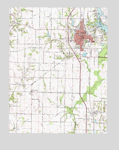
Sullivan, IN USGS Topographic Map
Click on map above to begin viewing in our Map Viewer.

This topographic map contains these locations and features:
Feature Name Type Latitude Longitude GNIS ID View Map
Bible View ChurchChurchN39.0912°W87.3942°431000View Map
Boone CemeteryCemeteryN39.0081°W87.4136°431337View Map
Buck CreekStreamN39.0423°W87.3972°431724View Map
Burnett CemeteryCemeteryN39.0495°W87.4895°431849View Map
Busseron Dam Number L-1DamN39.1067°W87.4200°447280View Map
Busseron Dam Number L-SDamN39.0967°W87.4484°447281View Map
Buttermilk CreekStreamN39.0506°W87.3881°431909View Map
Center Ridge CemeteryCemeteryN39.0925°W87.4225°432337View Map
Central Elementary SchoolSchoolN39.0981°W87.4078°447093View Map
City of SullivanCivilN39.0973°W87.4073°2395996View Map
Coffman CemeteryCemeteryN39.1020°W87.3911°432739View Map
Evangelic ChurchChurchN39.1081°W87.4792°434248View Map
Free CemeteryCemeteryN39.0915°W87.4263°434799View Map
Gill Township Volunteer Fire Department Station 2BuildingN39.0428°W87.4707°2626463View Map
Hollenback CemeteryCemeteryN39.0064°W87.4931°436324View Map
Lake SullivanReservoirN39.1087°W87.3910°444371View Map
McCammon CemeteryCemeteryN39.0086°W87.3964°438782View Map
Morgan CemeteryCemeteryN39.0406°W87.4311°439427View Map
Mount Tabor ChurchChurchN39.1178°W87.4986°439710View Map
Mount Zion CemeteryCemeteryN39.0470°W87.4797°439733View Map
New LebanonPopulated PlaceN39.0409°W87.4711°440072View Map
Parson CemeteryCemeteryN39.0209°W87.4625°440913View Map
PaxtonPopulated PlaceN39.0212°W87.3886°449706View Map
Pirtle CemeteryCemeteryN39.0053°W87.4286°441188View Map
Poplar CemeteryCemeteryN39.1109°W87.4945°441440View Map
Providence CemeteryCemeteryN39.0106°W87.3925°441618View Map
Purcell CemeteryCemeteryN39.0282°W87.3775°441649View Map
Robbins BranchStreamN39.0420°W87.3967°442136View Map
Rose ChapelChurchN39.0034°W87.4906°442289View Map
Snyder CemeteryCemeteryN39.0028°W87.3783°443744View Map
South CemeteryCemeteryN39.0281°W87.4428°443794View Map
SullivanPopulated PlaceN39.0953°W87.4059°444366View Map
Sullivan City Fire Department Station 1 HeadquartersBuildingN39.0960°W87.4087°2625871View Map
Sullivan City Fire Department Station 2BuildingN39.0962°W87.4006°2626027View Map
Sullivan CountyCivilN39.0888°W87.4147°450391View Map
Sullivan County AirportAirportN39.1141°W87.4473°449356View Map
Sullivan County Ambulance ServiceBuildingN39.1158°W87.4096°2719362View Map
Sullivan County ParkParkN39.1070°W87.3886°444368View Map
Sullivan County Sheriff's OfficeBuildingN39.0951°W87.4063°2758055View Map
Sullivan High SchoolSchoolN39.1039°W87.4103°447095View Map
Sullivan Junior High SchoolSchoolN39.1039°W87.4103°447094View Map
Sullivan Police DepartmentBuildingN39.0950°W87.4064°2758343View Map
Timmons CemeteryCemeteryN39.0919°W87.4259°444766View Map
Township of HamiltonCivilN39.1108°W87.3977°453366View Map
Walls CemeteryCemeteryN39.1189°W87.3867°445402View Map
WNDI-AM (Sullivan)TowerN39.0756°W87.3992°448461View Map
WNDI-FM (Sullivan)TowerN39.0934°W87.4439°448947View Map

Note: Coordinates in the location and feature list above are referenced to NAD83 datum.


Copyright (C) 2008-2024 Ryan Niemi / Sunset Dynamics ... All Rights Reserved