TopoQuest Logo
Do you find TopoQuest useful?
Help keep TopoQuest running and adding new maps/features by donating!
Bitcoin:  19c7KJd3qBynnjoSw5npx9KScwjBe4ifkT
Litecoin:  LXs6TkuXGGXo1vDsWCkWVdjQX94eUKd6ui
Home View Maps Find Maps Find Places Resources & Links


Blankston, Louisiana Topographic Map

USGS Map Title: Blankston, LA
USGS Map MRC: 32092B2
DRG (GeoTIFF) Download: o32092b2.tif


Neighboring USGS Topographic Map Quads:


  Chatham SE, LA  
32092C3
 

  Luna, LA  
32092C2
 

  Bosco, LA  
32092C1
 

  Vixen, LA  
32092B3
 

  Blankston, LA  
32092B2
 

  Riverton, LA  
32092B1
 

  Cotton Plant, LA  
32092A3
 

  Clark, LA  
32092A2
 

  Columbia, LA  
32092A1


Map MRC Location:

N33°
W93°
N33°
W92°
H8 H7 H6 H5 H4 H3 H2 H1
G8 G7 G6 G5 G4 G3 G2 G1
F8 F7 F6 F5 F4 F3 F2 F1
E8 E7 E6 E5 E4 E3 E2 E1
D8 D7 D6 D5 D4 D3 D2 D1
C8 C7 C6 C5 C4 C3 C2 C1
B8 B7 B6 B5 B4 B3 B2 B1
A8 A7 A6 A5 A4 A3 A2 A1
N32°
W93°
N32°
W92°

Blankston, LA USGS 1:24K Topographic Map Preview:
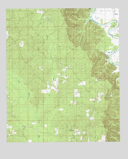
Blankston, LA USGS Topographic Map
Click on map above to begin viewing in our Map Viewer.

This topographic map contains these locations and features:
Feature Name Type Latitude Longitude GNIS ID View Map
Bills CreekStreamN32.1524°W92.2190°533124View Map
BlankstonPopulated PlaceN32.2421°W92.1324°533208View Map
Castor LandingLocaleN32.2449°W92.1540°546291View Map
Fellowship Baptist ChurchChurchN32.1977°W92.1915°554390View Map
Fellowship CemeteryCemeteryN32.1999°W92.1885°542393View Map
KCTO-FM (Columbia)TowerN32.1571°W92.1829°1632437View Map
Locust LandingLocaleN32.2238°W92.1326°546321View Map
Lone Grave BluffCliffN32.2052°W92.1390°546322View Map
Lost CreekStreamN32.1415°W92.2010°536739View Map
Lost Creek Gas FieldOilfieldN32.1765°W92.1843°542409View Map
Montgomery LandingLocaleN32.2343°W92.1474°546329View Map
Mount PleasantPopulated PlaceN32.1357°W92.1807°558843View Map
Mount Pleasant CemeteryCemeteryN32.1385°W92.1779°542411View Map
Mount Pleasant ChurchChurchN32.1368°W92.1801°537392View Map
New Testament ChurchChurchN32.1385°W92.2313°537636View Map
Old Mount Pleasant (historical)Populated PlaceN32.1502°W92.1899°546335View Map
Parish Governing Authority District 5CivilN32.1963°W92.1916°1930068View Map
Pinder BranchStreamN32.2493°W92.1543°538155View Map
Upper Lone Grave BayouStreamN32.2077°W92.1404°546349View Map
Ward 5 ChurchChurchN32.2240°W92.1918°540226View Map
Ward 5 SchoolSchoolN32.1718°W92.1937°540227View Map
Ward OneCivilN32.1949°W92.1857°544957View Map
Waverly LandingLocaleN32.2327°W92.1265°546351View Map
Winn BranchStreamN32.2024°W92.1382°540501View Map

Note: Coordinates in the location and feature list above are referenced to NAD83 datum.


Copyright (C) 2008-2024 Ryan Niemi / Sunset Dynamics ... All Rights Reserved