TopoQuest Logo
Do you find TopoQuest useful?
Help keep TopoQuest running and adding new maps/features by donating!
Bitcoin:  19c7KJd3qBynnjoSw5npx9KScwjBe4ifkT
Litecoin:  LXs6TkuXGGXo1vDsWCkWVdjQX94eUKd6ui
Home View Maps Find Maps Find Places Resources & Links


Stringtown, Missouri Topographic Map

USGS Map Title: Stringtown, MO
USGS Map MRC: 36090G5
DRG (GeoTIFF) Download: o36090g5.tif


Neighboring USGS Topographic Map Quads:


  Ellsinore, MO  
36090H6
 

  Williamsville, MO  
36090H5
 

  Hendrickson, MO  
36090H4
 

  Hogan Hollow, MO  
36090G6
 

  Stringtown, MO  
36090G5
 

  Poplar Bluff, MO  
36090G4
 

  Flatwoods, MO  
36090F6
 

  Fairdealing, MO  
36090F5
 

  Harviell, MO  
36090F4


Map MRC Location:

N37°
W91°
N37°
W90°
H8 H7 H6 H5 H4 H3 H2 H1
G8 G7 G6 G5 G4 G3 G2 G1
F8 F7 F6 F5 F4 F3 F2 F1
E8 E7 E6 E5 E4 E3 E2 E1
D8 D7 D6 D5 D4 D3 D2 D1
C8 C7 C6 C5 C4 C3 C2 C1
B8 B7 B6 B5 B4 B3 B2 B1
A8 A7 A6 A5 A4 A3 A2 A1
N36°
W91°
N36°
W90°

Stringtown, MO USGS 1:24K Topographic Map Preview:
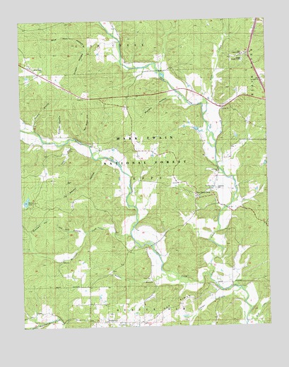
Stringtown, MO USGS Topographic Map
Click on map above to begin viewing in our Map Viewer.

This topographic map contains these locations and features:
Feature Name Type Latitude Longitude GNIS ID View Map
Bay Springs SchoolSchoolN36.7595°W90.5457°748722View Map
Beaver LakeReservoirN36.8017°W90.6225°765527View Map
Bethel ChapelChurchN36.8556°W90.6176°753642View Map
Blue Hole HollowValleyN36.8645°W90.5912°748926View Map
Butler County Fire Protection District Stringtown StationBuildingN36.7523°W90.5638°2620719View Map
Butler County Fire Protection District West Butler StationBuildingN36.8516°W90.6204°2620718View Map
Camp BranchStreamN36.8242°W90.5993°749170View Map
Cane Creek ChurchChurchN36.8131°W90.5248°753645View Map
Cane Creek School (historical)SchoolN36.8167°W90.5248°749190View Map
Carlton LakeReservoirN36.7967°W90.5718°764720View Map
Carlton Lake DamDamN36.7967°W90.5718°764719View Map
Crooked BranchStreamN36.8014°W90.5179°735271View Map
Eureka School (historical)SchoolN36.7601°W90.5998°749858View Map
Everhart HollowValleyN36.7906°W90.6215°749875View Map
Fletcher BranchStreamN36.7648°W90.5151°749946View Map
Garrettville ChurchChurchN36.8498°W90.5018°753644View Map
Gobbler HollowValleyN36.8284°W90.6040°750057View Map
Good Hope ChurchChurchN36.8070°W90.5276°750070View Map
Goose CreekStreamN36.8412°W90.5304°750080View Map
Grassy HollowValleyN36.8662°W90.5796°750107View Map
HalloranPopulated PlaceN36.8334°W90.6182°735269View Map
Halloran School (historical)SchoolN36.8323°W90.6248°750199View Map
Harmon BranchStreamN36.8301°W90.6176°750231View Map
Houts CemeteryCemeteryN36.7698°W90.5604°753647View Map
Hurricane CreekStreamN36.7872°W90.5698°750430View Map
Karls LakeReservoirN36.8307°W90.5358°762495View Map
Karls Lake Lower DamDamN36.8301°W90.5351°762494View Map
Kerns ChapelChurchN36.7517°W90.5740°753648View Map
Mallady HollowValleyN36.8434°W90.5487°750913View Map
Millers BridgeBridgeN36.7987°W90.5215°735270View Map
MilltownPopulated PlaceN36.7776°W90.6051°751105View Map
Nickey BridgeBridgeN36.8464°W90.5462°735268View Map
Oak RidgeRidgeN36.7576°W90.5496°751391View Map
Old Still HollowValleyN36.7892°W90.5943°751427View Map
Pine Grove CampLocaleN36.8034°W90.5359°751605View Map
Procter BranchStreamN36.7709°W90.5523°751762View Map
Pry Chapel (historical)ChurchN36.8595°W90.5507°751770View Map
Rushville CampLocaleN36.8226°W90.5998°735267View Map
Rushville School (historical)SchoolN36.8051°W90.5815°751985View Map
Sears Youth CenterLocaleN36.8609°W90.5121°753643View Map
Smoky HollowValleyN36.8176°W90.5832°752227View Map
Sparkman CemeteryCemeteryN36.8064°W90.5257°752277View Map
StringtownPopulated PlaceN36.7528°W90.5829°752399View Map
Tenmile CreekStreamN36.7703°W90.5301°748545View Map
Township of EppsCivilN36.8096°W90.5625°766353View Map
Victory School (historical)SchoolN36.8542°W90.5465°752710View Map
Wet Slash HollowValleyN36.8256°W90.5887°752840View Map

Note: Coordinates in the location and feature list above are referenced to NAD83 datum.


Copyright (C) 2008-2024 Ryan Niemi / Sunset Dynamics ... All Rights Reserved