TopoQuest Logo
Do you find TopoQuest useful?
Help keep TopoQuest running and adding new maps/features by donating!
Bitcoin:  19c7KJd3qBynnjoSw5npx9KScwjBe4ifkT
Litecoin:  LXs6TkuXGGXo1vDsWCkWVdjQX94eUKd6ui
Home View Maps Find Maps Find Places Resources & Links


Strawn East, Texas Topographic Map

USGS Map Title: Strawn East, TX
USGS Map MRC: 32098E4
DRG (GeoTIFF) Download: o32098e4.tif


Neighboring USGS Topographic Map Quads:


  Caddo NE, TX  
32098F5
 

  Metcalf Gap, TX  
32098F4
 

  Lone Camp, TX  
32098F3
 

  Strawn West, TX  
32098E5
 

  Strawn East, TX  
32098E4
 

  Gordon, TX  
32098E3
 

  Bear Mountain, TX  
32098D5
 

  Reddy Mountain, TX  
32098D4
 

  Turkey Creek, TX  
32098D3


Map MRC Location:

N33°
W99°
N33°
W98°
H8 H7 H6 H5 H4 H3 H2 H1
G8 G7 G6 G5 G4 G3 G2 G1
F8 F7 F6 F5 F4 F3 F2 F1
E8 E7 E6 E5 E4 E3 E2 E1
D8 D7 D6 D5 D4 D3 D2 D1
C8 C7 C6 C5 C4 C3 C2 C1
B8 B7 B6 B5 B4 B3 B2 B1
A8 A7 A6 A5 A4 A3 A2 A1
N32°
W99°
N32°
W98°

Strawn East, TX USGS 1:24K Topographic Map Preview:
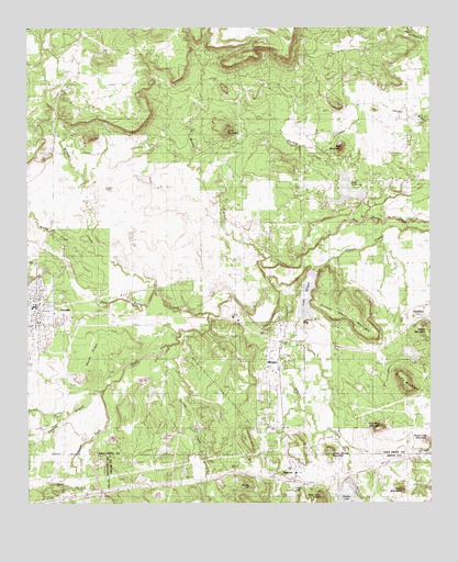
Strawn East, TX USGS Topographic Map
Click on map above to begin viewing in our Map Viewer.

This topographic map contains these locations and features:
Feature Name Type Latitude Longitude GNIS ID View Map
Bear CreekStreamN32.5062°W98.4795°1330221View Map
Boles Rector Oil FieldOilfieldN32.5699°W98.4495°1331027View Map
Brushy MountainSummitN32.5307°W98.3825°1331454View Map
City of MingusCivilN32.5364°W98.4249°2411120View Map
City of StrawnCivilN32.5509°W98.4979°2411989View Map
Coal Mine MountainSummitN32.5199°W98.3917°1333026View Map
Dairy MountainSummitN32.5032°W98.3845°1333876View Map
Davidson CemeteryCemeteryN32.5407°W98.4514°1334074View Map
Dickson-Walker MountainSummitN32.5443°W98.3928°1334349View Map
Edwards BranchStreamN32.5299°W98.4773°1335116View Map
Fox MountainSummitN32.5935°W98.4020°1336137View Map
Fox Mountain CemeteryCemeteryN32.5865°W98.3817°1336138View Map
Gilmore CreekStreamN32.5221°W98.4906°1336540View Map
Gordon City ReservoirReservoirN32.5398°W98.3820°1861815View Map
Gordon City Reservoir DamDamN32.5418°W98.3837°1861814View Map
Gordon LakeLakeN32.5134°W98.3918°2772070View Map
Guest CemeteryCemeteryN32.5771°W98.4367°1337100View Map
Hutchins CemeteryCemeteryN32.5651°W98.4881°1338333View Map
Italian HillSummitN32.5160°W98.4323°1338517View Map
Lake C B LongLakeN32.5815°W98.4004°1889693View Map
Lake C B LongReservoirN32.5801°W98.3953°1862977View Map
Lake C B Long DamDamN32.5801°W98.3953°1862976View Map
Lake MingusReservoirN32.5548°W98.4136°1348186View Map
Little LakeLakeN32.5022°W98.4186°1340129View Map
LyraPopulated PlaceN32.5554°W98.4689°1378625View Map
McSpadden CemeteryCemeteryN32.5579°W98.4012°1341280View Map
Middle CreekStreamN32.5668°W98.4795°1341483View Map
MingusPopulated PlaceN32.5379°W98.4223°1341720View Map
Mingus City HallBuildingN32.5410°W98.4215°2753790View Map
Mingus Lake DamDamN32.5518°W98.4120°1861804View Map
Mingus Post OfficePost OfficeN32.5429°W98.4214°2731621View Map
Mount Marion CemeteryCemeteryN32.5393°W98.4978°1342050View Map
New York HillSummitN32.5032°W98.4098°1342549View Map
Panther CreekStreamN32.5782°W98.3937°1348469View Map
Rocky CreekStreamN32.5635°W98.4278°1345470View Map
Roundtop MountainSummitN32.5165°W98.3773°1345705View Map
Skunk RidgeRidgeN32.5365°W98.4823°1347215View Map
Smith CemeteryCemeteryN32.5932°W98.3856°1347259View Map
South Fork Palo Pinto CreekStreamN32.5504°W98.4448°1347456View Map
Steam Shovel MountainSummitN32.5129°W98.4070°1346959View Map
StrawnPopulated PlaceN32.5521°W98.4981°1347995View Map
Strawn City HallBuildingN32.5519°W98.4971°2753940View Map
Strawn Post OfficePost OfficeN32.5525°W98.4965°2731853View Map
Strawn Volunteer Fire DepartmentBuildingN32.5425°W98.4992°2552093View Map
Stump HillSummitN32.5051°W98.4326°1348020View Map
Tater HillSummitN32.5479°W98.4139°1348271View Map
ThurberPopulated PlaceN32.5074°W98.4173°1379160View Map
Thurber CemeteryCemeteryN32.5129°W98.4178°1348538View Map
Thurber Historic DistrictLocaleN32.5090°W98.4170°2031918View Map
Thurber LakeReservoirN32.5017°W98.4016°1856043View Map
Thurber Lake AirportAirportN32.5003°W98.3943°1387643View Map
Thurber Lake DamDamN32.5051°W98.4003°1856042View Map
Thurber Lake Number 2ReservoirN32.5035°W98.4187°1863970View Map
Thurber Lake Number 2 DamDamN32.5035°W98.4187°1863969View Map
Thurber Lake Number 3ReservoirN32.5018°W98.4653°1863968View Map
Thurber Lake Number 3 DamDamN32.5018°W98.4653°1863967View Map
Turkey CreekStreamN32.5424°W98.4548°1376527View Map
Walnut CreekStreamN32.5557°W98.4609°1349430View Map
Wilbar MountainSummitN32.5457°W98.3773°1350049View Map
Wolf MountainSummitN32.5982°W98.4378°1350479View Map

Note: Coordinates in the location and feature list above are referenced to NAD83 datum.


Copyright (C) 2008-2024 Ryan Niemi / Sunset Dynamics ... All Rights Reserved