TopoQuest Logo
Do you find TopoQuest useful?
Help keep TopoQuest running and adding new maps/features by donating!
Bitcoin:  19c7KJd3qBynnjoSw5npx9KScwjBe4ifkT
Litecoin:  LXs6TkuXGGXo1vDsWCkWVdjQX94eUKd6ui
Home View Maps Find Maps Find Places Resources & Links


Stevenson, Alabama Topographic Map

USGS Map Title: Stevenson, AL
USGS Map MRC: 34085G7
DRG (GeoTIFF) Download: o34085g7.tif


Neighboring USGS Topographic Map Quads:


  Eureka, AL  
34085H8
 

  Doran Cove, AL  
34085H7
 

  Bridgeport, AL  
34085H6
 

  Wannville, AL  
34085G8
 

  Stevenson, AL  
34085G7
 

  Flat Rock, AL  
34085G6
 

  Hollywood, AL  
34085F8
 

  Henagar, AL  
34085F7
 

  Ider, AL  
34085F6


Map MRC Location:

N35°
W86°
N35°
W85°
H8 H7 H6 H5 H4 H3 H2 H1
G8 G7 G6 G5 G4 G3 G2 G1
F8 F7 F6 F5 F4 F3 F2 F1
E8 E7 E6 E5 E4 E3 E2 E1
D8 D7 D6 D5 D4 D3 D2 D1
C8 C7 C6 C5 C4 C3 C2 C1
B8 B7 B6 B5 B4 B3 B2 B1
A8 A7 A6 A5 A4 A3 A2 A1
N34°
W86°
N34°
W85°

Stevenson, AL USGS 1:24K Topographic Map Preview:
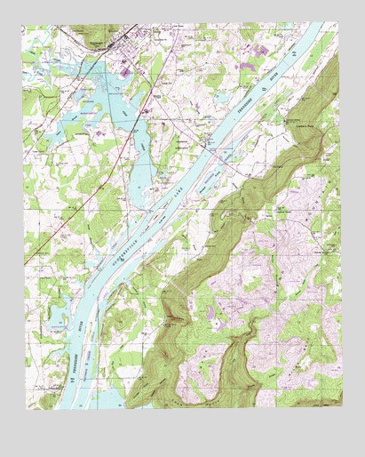
Stevenson, AL USGS Topographic Map
Click on map above to begin viewing in our Map Viewer.

This topographic map contains these locations and features:
Feature Name Type Latitude Longitude GNIS ID View Map
Baldridge Reservation (historical)CivilN34.8373°W85.8155°113407View Map
Bengis CreekStreamN34.8559°W85.8369°113915View Map
Brogue BranchStreamN34.7954°W85.8447°114942View Map
Burch CemeteryCemeteryN34.8717°W85.8533°115209View Map
Cameronsville School (historical)SchoolN34.8567°W85.7583°139123View Map
Campbell ChapelChurchN34.8367°W85.8705°139125View Map
Caperton CemeteryCemeteryN34.8420°W85.8077°115602View Map
Caperton ChapelChurchN34.8140°W85.7761°115603View Map
Caperton FerryCrossingN34.8356°W85.8036°115432View Map
Captain John Snodgrass BridgeBridgeN34.8334°W85.8028°115610View Map
Card SwitchPopulated PlaceN34.8729°W85.8555°115611View Map
Cawlfield CemeteryCemeteryN34.8595°W85.8069°115732View Map
Cedar GrovePopulated PlaceN34.8334°W85.8728°151723View Map
Center Star Missionary Baptist ChurchChurchN34.8706°W85.8236°115871View Map
Church of ChristChurchN34.8642°W85.8330°139137View Map
Coalbank PointCapeN34.8412°W85.7600°116307View Map
Coffee Bend BarBarN34.7715°W85.8536°139140View Map
Coffee CemeteryCemeteryN34.7754°W85.8394°149560View Map
Coffey CemeteryCemeteryN34.7570°W85.8633°149562View Map
Coffeys FerryCrossingN34.7573°W85.8591°116364View Map
Coon CreekStreamN34.8604°W85.8666°116556View Map
Craze BendBendN34.7726°W85.8019°116832View Map
Cross CemeteryCemeteryN34.8295°W85.8614°116893View Map
Cross CemeteryCemeteryN34.8329°W85.8416°1700438View Map
Cross CemeteryCemeteryN34.8181°W85.8480°149564View Map
Crow BarBarN34.8176°W85.8200°139148View Map
Crow CreekStreamN34.8140°W85.8261°116918View Map
Crow Creek IslandIslandN34.8140°W85.8216°116919View Map
Crow Creek Wildlife Management AreaParkN34.8501°W85.8583°139149View Map
Cumberland ChurchChurchN34.8334°W85.8750°116960View Map
Deal CreekStreamN34.7579°W85.8411°117170View Map
Devils HollowValleyN34.7795°W85.8214°117260View Map
FabiusPopulated PlaceN34.8109°W85.7775°156330View Map
First United Methodist Church of StevensonChurchN34.8681°W85.8350°139167View Map
Foshee CemeteryCemeteryN34.8592°W85.8122°118527View Map
Hunter PointCapeN34.7567°W85.8278°120556View Map
Hymer (historical)Populated PlaceN34.8292°W85.8447°1959051View Map
Johnson CemeteryCemeteryN34.8009°W85.8711°120944View Map
Kings BendCapeN34.7656°W85.7647°121234View Map
Marshall BranchStreamN34.8167°W85.8139°122304View Map
Mason HollowValleyN34.7509°W85.8261°122365View Map
McCoy Grove ChurchChurchN34.7770°W85.8205°122496View Map
McCoy School (historical)SchoolN34.7770°W85.8211°139214View Map
Monday BranchStreamN34.7556°W85.7903°152357View Map
Mud Creek Public Shooting AreaParkN34.7937°W85.8472°139228View Map
New TownPopulated PlaceN34.8734°W85.8175°123910View Map
Nichols BranchStreamN34.7917°W85.8358°123937View Map
Norwood CoveValleyN34.8398°W85.7730°124031View Map
Norwood SpringSpringN34.8430°W85.7713°124036View Map
Oak Grove ChurchChurchN34.8076°W85.8614°124104View Map
Old FabiusPopulated PlaceN34.8290°W85.7772°156832View Map
Old Fabius ChurchChurchN34.8292°W85.7761°139242View Map
Pinder HillPopulated PlaceN34.8562°W85.8208°156889View Map
Pump Spring BranchStreamN34.8412°W85.7983°125358View Map
Raccoon Creek Public Hunting AreaParkN34.7709°W85.8486°139255View Map
Rocky BranchStreamN34.7851°W85.7747°125820View Map
Ross BranchStreamN34.7987°W85.7575°153220View Map
Rudders ChapelChurchN34.8517°W85.8203°126009View Map
Rudders Ferry (historical)CrossingN34.8584°W85.7750°139266View Map
Slaton BranchStreamN34.8515°W85.8455°126959View Map
Sterne BranchStreamN34.8095°W85.8166°127364View Map
Sterne CemeteryCemeteryN34.8023°W85.8050°127365View Map
StevensonPopulated PlaceN34.8687°W85.8394°127370View Map
Stevenson High SchoolSchoolN34.8626°W85.8347°139295View Map
Stevenson Historic DistrictParkN34.8687°W85.8389°158347View Map
Stevenson Municipal ParkParkN34.8526°W85.8319°127373View Map
Stevenson Police DepartmentBuildingN34.8683°W85.8376°2751786View Map
Stevenson Post OfficePost OfficeN34.8675°W85.8362°2770176View Map
Stevenson Volunteer Fire Department Station 2BuildingN34.8705°W85.8321°2682686View Map
Stevenson Volunteer Fire Department Station 3BuildingN34.8625°W85.8186°2683211View Map
Sulphur Springs Church (historical)ChurchN34.8006°W85.7503°1700443View Map
Sulphur Springs School (historical)SchoolN34.8037°W85.7611°139297View Map
Tally CemeteryCemeteryN34.7937°W85.8664°127656View Map
Warren Smith CreekStreamN34.7781°W85.7853°128587View Map
Warren Smith HillSummitN34.8004°W85.7519°128588View Map
Wheeler CemeteryCemeteryN34.8026°W85.7519°128830View Map
Wimberley CemeteryCemeteryN34.8676°W85.8139°129104View Map
Wolf HollowValleyN34.8070°W85.8019°129169View Map
WVSV-FM (Stevenson)TowerN34.8279°W85.7650°161233View Map
YuccaPopulated PlaceN34.7992°W85.8066°157290View Map
Yucca (historical)Populated PlaceN34.7712°W85.8286°1959075View Map
Zion ChurchChurchN34.8723°W85.8255°129344View Map

Note: Coordinates in the location and feature list above are referenced to NAD83 datum.


Copyright (C) 2008-2024 Ryan Niemi / Sunset Dynamics ... All Rights Reserved