TopoQuest Logo
Do you find TopoQuest useful?
Help keep TopoQuest running and adding new maps/features by donating!
Bitcoin:  19c7KJd3qBynnjoSw5npx9KScwjBe4ifkT
Litecoin:  LXs6TkuXGGXo1vDsWCkWVdjQX94eUKd6ui
Home View Maps Find Maps Find Places Resources & Links


Blaisdell Lake, Wisconsin Topographic Map

USGS Map Title: Blaisdell Lake, WI
USGS Map MRC: 45090H8
DRG (GeoTIFF) Download: o45090h8.tif


Neighboring USGS Topographic Map Quads:


  Moose Lake, WI  
46091A1
 

  Clam Lake SW, WI  
46090A8
 

  Clam Lake SE, WI  
46090A7
 

  Barker Lake, WI  
45091H1
 

  Blaisdell Lake, WI  
45090H8
 

  Loretta, WI  
45090H7
 

  Winter, WI  
45091G1
 

  Lake Winter, WI  
45090G8
 

  Babbs Island, WI  
45090G7


Map MRC Location:

N46°
W91°
N46°
W90°
H8 H7 H6 H5 H4 H3 H2 H1
G8 G7 G6 G5 G4 G3 G2 G1
F8 F7 F6 F5 F4 F3 F2 F1
E8 E7 E6 E5 E4 E3 E2 E1
D8 D7 D6 D5 D4 D3 D2 D1
C8 C7 C6 C5 C4 C3 C2 C1
B8 B7 B6 B5 B4 B3 B2 B1
A8 A7 A6 A5 A4 A3 A2 A1
N45°
W91°
N45°
W90°

Blaisdell Lake, WI USGS 1:24K Topographic Map Preview:
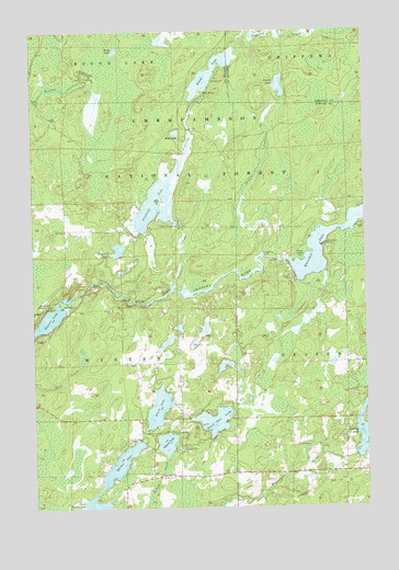
Blaisdell Lake, WI USGS Topographic Map
Click on map above to begin viewing in our Map Viewer.

This topographic map contains these locations and features:
Feature Name Type Latitude Longitude GNIS ID View Map
235 ReservoirReservoirN45.9300°W90.9652°1793071View Map
Barber LakeLakeN45.8820°W90.9717°1578692View Map
Barber Lake School (historical)SchoolN45.8855°W90.9566°1833736View Map
Black Dan LakeLakeN45.8978°W90.9324°1578800View Map
Black LakeLakeN45.9885°W90.9328°1578802View Map
Black Lake 4ReservoirN45.9833°W90.9335°1793119View Map
Black Lake CampgroundLocaleN45.9877°W90.9299°1580987View Map
Black Lake DamDamN45.9833°W90.9335°1793118View Map
Black Lake Fire Tower (historical)TowerN45.9891°W90.9546°1833739View Map
Black Lake TrailTrailN45.9905°W90.9307°1580988View Map
Blaisdell LakeLakeN45.9430°W90.8952°1578811View Map
Blue Gill LakeLakeN45.9426°W90.9679°1578815View Map
Brunet Flowage 30ReservoirN45.8883°W90.8785°1792039View Map
Fishtrap CreekStreamN45.9325°W90.9477°1579246View Map
Fishtrap LakeLakeN45.9516°W90.9522°1579247View Map
Fishtrap Lake 161ReservoirN45.9516°W90.9522°1792241View Map
Fishtrap Lake DamDamN45.9500°W90.9452°1792240View Map
Glenwood CampLocaleN45.9436°W90.8896°1579334View Map
Hunter LakeLakeN45.9240°W90.9951°1579498View Map
Island LakeLakeN45.8919°W90.9506°1579517View Map
Kocmoud LakeLakeN45.9126°W90.9271°2548619View Map
Loretta LakeReservoirN45.8929°W90.8772°1579758View Map
Mud LakeLakeN45.9732°W90.9456°1579959View Map
Perch LakeLakeN45.9011°W90.9537°1580112View Map
Snag LakeLakeN45.9949°W90.9681°1580440View Map
Snoose CreekStreamN45.9413°W90.9132°1580442View Map
Snoose LakeLakeN45.9854°W90.9066°1580443View Map
Thompson PitMineN45.8883°W90.9394°2635550View Map
Upper Brunet 2 WP 400 DamDamN45.8883°W90.8785°1792038View Map
We Ha Kee Church CampLocaleN45.9277°W90.9935°1580734View Map
Winter 2WP806 DamDamN45.9300°W90.9652°1793070View Map

Note: Coordinates in the location and feature list above are referenced to NAD83 datum.


Copyright (C) 2008-2024 Ryan Niemi / Sunset Dynamics ... All Rights Reserved