TopoQuest Logo
Do you find TopoQuest useful?
Help keep TopoQuest running and adding new maps/features by donating!
Bitcoin:  19c7KJd3qBynnjoSw5npx9KScwjBe4ifkT
Litecoin:  LXs6TkuXGGXo1vDsWCkWVdjQX94eUKd6ui
Home View Maps Find Maps Find Places Resources & Links


Steinhatchee, Florida Topographic Map

USGS Map Title: Steinhatchee, FL
USGS Map MRC: 29083F4
DRG (GeoTIFF) Download: o29083f4.tif


Neighboring USGS Topographic Map Quads:


  Keaton Beach, FL  
29083G5
 

  Salem SW, FL  
29083G4
 

  Clara, FL  
29083G3
 

  Crooked Point, FL  
29083F5
 

  Steinhatchee, FL  
29083F4
 

  Jena, FL  
29083F3


  Steinhatchee SW, FL  
29083E4
 

  Steinhatchee SE, FL  
29083E3


Map MRC Location:

N30°
W84°
N30°
W83°
H8 H7 H6 H5 H4 H3 H2 H1
G8 G7 G6 G5 G4 G3 G2 G1
F8 F7 F6 F5 F4 F3 F2 F1
E8 E7 E6 E5 E4 E3 E2 E1
D8 D7 D6 D5 D4 D3 D2 D1
C8 C7 C6 C5 C4 C3 C2 C1
B8 B7 B6 B5 B4 B3 B2 B1
A8 A7 A6 A5 A4 A3 A2 A1
N29°
W84°
N29°
W83°

Steinhatchee, FL USGS 1:24K Topographic Map Preview:
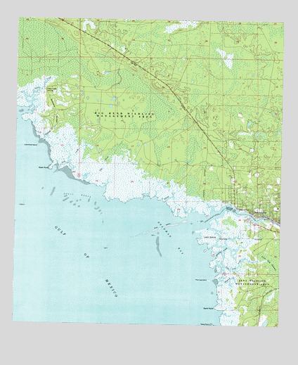
Steinhatchee, FL USGS Topographic Map
Click on map above to begin viewing in our Map Viewer.

This topographic map contains these locations and features:
Feature Name Type Latitude Longitude GNIS ID View Map
Bayview CreekStreamN29.7002°W83.4879°278260View Map
Bivens CreekStreamN29.6755°W83.4290°278873View Map
Dallus CreekStreamN29.7127°W83.4949°281264View Map
Dallus Creek LandingPopulated PlaceN29.7213°W83.4865°294736View Map
Deadman BayBayN29.6594°W83.4251°281394View Map
Hickory RidgeRidgeN29.7183°W83.4842°283967View Map
Howard CreekStreamN29.6430°W83.4037°284342View Map
Jack CreekStreamN29.6886°W83.4799°284653View Map
Lazy IslandIslandN29.6608°W83.4076°285409View Map
Little Grass IslandIslandN29.6977°W83.4899°285693View Map
Pine Log CreekStreamN29.6483°W83.4051°288900View Map
Pine Log IslandIslandN29.6433°W83.4076°288905View Map
Porpoise CreekStreamN29.6527°W83.4062°289224View Map
Rock PointCapeN29.6883°W83.4840°289842View Map
Salt CreekStreamN29.6838°W83.4674°290427View Map
Sand PointCapeN29.6322°W83.4051°290550View Map
Shell ReefsBarN29.6755°W83.4707°290996View Map
SteinhatcheePopulated PlaceN29.6711°W83.3876°291672View Map
Steinhatchee Census Designated PlaceCensusN29.6794°W83.3837°2628534View Map
Steinhatchee RiverStreamN29.6658°W83.4157°294162View Map
Steinhatchee SchoolSchoolN29.6733°W83.3758°299415View Map
Steinhatchee Volunteer Fire and RescueBuildingN29.6745°W83.3753°2644617View Map
Stewart CityPopulated PlaceN29.6686°W83.3882°300237View Map
Tide Swamp Wildlife Management AreaParkN29.7294°W83.4790°304092View Map

Note: Coordinates in the location and feature list above are referenced to NAD83 datum.


Copyright (C) 2008-2024 Ryan Niemi / Sunset Dynamics ... All Rights Reserved