TopoQuest Logo
Do you find TopoQuest useful?
Help keep TopoQuest running and adding new maps/features by donating!
Bitcoin:  19c7KJd3qBynnjoSw5npx9KScwjBe4ifkT
Litecoin:  LXs6TkuXGGXo1vDsWCkWVdjQX94eUKd6ui
Home View Maps Find Maps Find Places Resources & Links


Starks, Louisiana Topographic Map

USGS Map Title: Starks, LA
USGS Map MRC: 30093C6
DRG (GeoTIFF) Download: o30093c6.tif


Neighboring USGS Topographic Map Quads:


  Sudduth Bluff, TX  
30093D7
 

  Shoats Creek, LA  
30093D6
 

  Clark Hollow, LA  
30093D5
 

  Hartburg, TX  
30093C7
 

  Starks, LA  
30093C6
 

  Lunita, LA  
30093C5
 

  Mauriceville, TX  
30093B7
 

  Echo, TX  
30093B6
 

  Vinton, LA  
30093B5


Map MRC Location:

N31°
W94°
N31°
W93°
H8 H7 H6 H5 H4 H3 H2 H1
G8 G7 G6 G5 G4 G3 G2 G1
F8 F7 F6 F5 F4 F3 F2 F1
E8 E7 E6 E5 E4 E3 E2 E1
D8 D7 D6 D5 D4 D3 D2 D1
C8 C7 C6 C5 C4 C3 C2 C1
B8 B7 B6 B5 B4 B3 B2 B1
A8 A7 A6 A5 A4 A3 A2 A1
N30°
W94°
N30°
W93°

Starks, LA USGS 1:24K Topographic Map Preview:
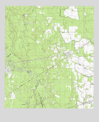
Starks, LA USGS Topographic Map
Click on map above to begin viewing in our Map Viewer.

This topographic map contains these locations and features:
Feature Name Type Latitude Longitude GNIS ID View Map
Alligator LakeLakeN30.3535°W93.7221°553290View Map
Alligator ParkParkN30.3635°W93.7227°542017View Map
Ashworth SloughGutN30.3224°W93.6971°532236View Map
Bess BranchStreamN30.2960°W93.7213°532963View Map
Calcasieu Parish Library Starks BranchBuildingN30.3187°W93.6623°2603041View Map
Calvary Apostolic ChurchChurchN30.3206°W93.6615°2601418View Map
Cutoff BayouStreamN30.2802°W93.7041°534320View Map
DeweyvillePopulated PlaceN30.2977°W93.7435°1334321View Map
Deweyville Post OfficePost OfficeN30.2962°W93.7448°2731422View Map
Doyle CemeteryCemeteryN30.3016°W93.6749°534580View Map
First Baptist ChurchChurchN30.3175°W93.6613°2601759View Map
First Pentecostal ChurchChurchN30.3118°W93.6621°2601974View Map
Fountain CemeteryCemeteryN30.3557°W93.7150°535059View Map
Long SloughStreamN30.2958°W93.7213°536715View Map
Miller CemeteryCemeteryN30.3027°W93.6618°537132View Map
Northwest Starks Gas FieldOilfieldN30.3369°W93.7321°551327View Map
Patterson SloughStreamN30.3099°W93.7224°538018View Map
RuliffPopulated PlaceN30.2741°W93.7327°1378996View Map
Saint Mary CemeteryCemeteryN30.3166°W93.6388°542024View Map
Saint Mary ChurchChurchN30.3180°W93.6474°542025View Map
South Newton Emergency Services District 1BuildingN30.3006°W93.7483°2655531View Map
StarksPopulated PlaceN30.3155°W93.6618°539629View Map
Starks Census Designated PlaceCensusN30.3105°W93.6667°2586712View Map
Starks High SchoolSchoolN30.3163°W93.6627°551368View Map
Starks Lookout TowerLocaleN30.3227°W93.6629°551369View Map
Starks Oil FieldOilfieldN30.2602°W93.6313°556138View Map
Starks Post OfficePost OfficeN30.3145°W93.6612°1631650View Map
Starks Ward 5 Volunteer Fire DepartmentBuildingN30.3149°W93.6679°2691661View Map
Stevenson LakeLakeN30.3240°W93.7496°539667View Map
Ward FiveCivilN30.3263°W93.6621°544953View Map
Wembly IslandIslandN30.2824°W93.7032°540292View Map

Note: Coordinates in the location and feature list above are referenced to NAD83 datum.


Copyright (C) 2008-2024 Ryan Niemi / Sunset Dynamics ... All Rights Reserved