TopoQuest Logo
Do you find TopoQuest useful?
Help keep TopoQuest running and adding new maps/features by donating!
Bitcoin:  19c7KJd3qBynnjoSw5npx9KScwjBe4ifkT
Litecoin:  LXs6TkuXGGXo1vDsWCkWVdjQX94eUKd6ui
Home View Maps Find Maps Find Places Resources & Links


Standish, Missouri Topographic Map

USGS Map Title: Standish, MO
USGS Map MRC: 39093D4
DRG (GeoTIFF) Download: o39093d4.tif


Neighboring USGS Topographic Map Quads:


  Coloma, MO  
39093E5
 

  Tina, MO  
39093E4
 

  Hale, MO  
39093E3
 

  Bogard, MO  
39093D5
 

  Standish, MO  
39093D4
 

  Bosworth, MO  
39093D3
 

  Carrollton West, MO  
39093C5
 

  Carrollton East, MO  
39093C4
 

  Miami Station, MO  
39093C3


Map MRC Location:

N40°
W94°
N40°
W93°
H8 H7 H6 H5 H4 H3 H2 H1
G8 G7 G6 G5 G4 G3 G2 G1
F8 F7 F6 F5 F4 F3 F2 F1
E8 E7 E6 E5 E4 E3 E2 E1
D8 D7 D6 D5 D4 D3 D2 D1
C8 C7 C6 C5 C4 C3 C2 C1
B8 B7 B6 B5 B4 B3 B2 B1
A8 A7 A6 A5 A4 A3 A2 A1
N39°
W94°
N39°
W93°

Standish, MO USGS 1:24K Topographic Map Preview:
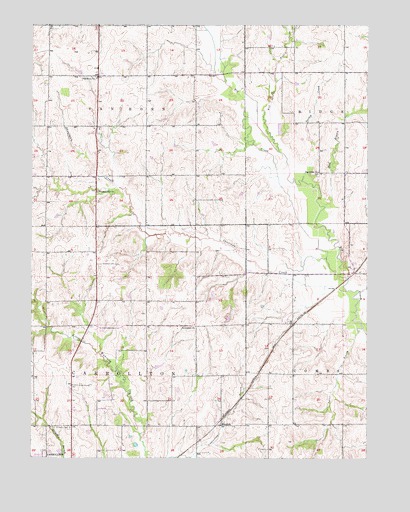
Standish, MO USGS Topographic Map
Click on map above to begin viewing in our Map Viewer.

This topographic map contains these locations and features:
Feature Name Type Latitude Longitude GNIS ID View Map
Bethlehem ChurchChurchN39.4131°W93.4391°731530View Map
Big Creek ChurchChurchN39.4578°W93.3933°714161View Map
Carroll County Memorial HospitalHospitalN39.3768°W93.4933°2655057View Map
Center Grove School (historical)SchoolN39.4209°W93.4774°746952View Map
Cottonwood School (historical)SchoolN39.3845°W93.4394°746954View Map
Johnson LakeReservoirN39.3766°W93.4895°761259View Map
Johnson Lake DamDamN39.3767°W93.4885°761258View Map
Liberty School (historical)SchoolN39.4136°W93.4427°746953View Map
Mud BranchStreamN39.4475°W93.3908°723008View Map
Mud Branch School (historical)SchoolN39.4706°W93.3833°746956View Map
North Baker School (historical)SchoolN39.4709°W93.4388°746955View Map
Parker BranchStreamN39.4128°W93.3766°724029View Map
Pence DamDamN39.4067°W93.4535°761361View Map
Pence LakeReservoirN39.4067°W93.4535°761362View Map
Pleasant Hill ChurchChurchN39.4520°W93.4758°724538View Map
Saint Marys CemeteryCemeteryN39.3836°W93.4858°725838View Map
Shootman CreekStreamN39.4275°W93.3833°726404View Map
Shootman School (historical)SchoolN39.4286°W93.3985°746958View Map
StandishPopulated PlaceN39.3845°W93.4294°730223View Map
Taylor School (historical)SchoolN39.4567°W93.4760°746951View Map
Township of CarrolltonCivilN39.3987°W93.4759°766405View Map
Township of Van HornCivilN39.4853°W93.4766°766423View Map
Turkey CreekStreamN39.4553°W93.3997°727850View Map
Van Horn ChurchChurchN39.4850°W93.4760°728115View Map
Van Horn School (historical)SchoolN39.4945°W93.4935°746950View Map
Whippoorwill School (historical)SchoolN39.4417°W93.4385°746957View Map
Wolf BranchStreamN39.4636°W93.4080°729032View Map
Woods School (historical)SchoolN39.3992°W93.4024°746959View Map

Note: Coordinates in the location and feature list above are referenced to NAD83 datum.


Copyright (C) 2008-2024 Ryan Niemi / Sunset Dynamics ... All Rights Reserved