TopoQuest Logo
Do you find TopoQuest useful?
Help keep TopoQuest running and adding new maps/features by donating!
Bitcoin:  19c7KJd3qBynnjoSw5npx9KScwjBe4ifkT
Litecoin:  LXs6TkuXGGXo1vDsWCkWVdjQX94eUKd6ui
Home View Maps Find Maps Find Places Resources & Links


Springerville, Arizona Topographic Map

USGS Map Title: Springerville, AZ
USGS Map MRC: 34109B3
DRG (GeoTIFF) Download: o34109b3.tif


Neighboring USGS Topographic Map Quads:


  Lyman Lake SW, AZ  
34109C4
 

  Lyman Lake, AZ  
34109C3
 

  Voigt Ranch, AZ  
34109C2
 

  Springerville NW, AZ  
34109B4
 

  Springerville, AZ  
34109B3
 

  Coyote Hills, AZ  
34109B2
 

  Greer, AZ  
34109A4
 

  Eagar, AZ  
34109A3
 

  Nelson Reservoir, AZ  
34109A2


Map MRC Location:

N35°
W110°
N35°
W109°
H8 H7 H6 H5 H4 H3 H2 H1
G8 G7 G6 G5 G4 G3 G2 G1
F8 F7 F6 F5 F4 F3 F2 F1
E8 E7 E6 E5 E4 E3 E2 E1
D8 D7 D6 D5 D4 D3 D2 D1
C8 C7 C6 C5 C4 C3 C2 C1
B8 B7 B6 B5 B4 B3 B2 B1
A8 A7 A6 A5 A4 A3 A2 A1
N34°
W110°
N34°
W109°

Springerville, AZ USGS 1:24K Topographic Map Preview:
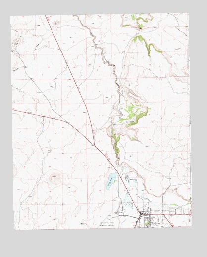
Springerville, AZ USGS Topographic Map
Click on map above to begin viewing in our Map Viewer.

This topographic map contains these locations and features:
Feature Name Type Latitude Longitude GNIS ID View Map
Apache and Sitgraves Forest Supervisor OfficeLocaleN34.1287°W109.2893°41661View Map
Apache County Sheriff's Office Round ValleyBuildingN34.1289°W109.2889°2751603View Map
Becker LakeLakeN34.1530°W109.3064°26164View Map
Casa Malpais CampgroundLocaleN34.1504°W109.2992°2669878View Map
Casa Malpais SiteParkN34.1597°W109.2900°2499878View Map
First Assembly of GodChurchN34.1333°W109.2639°2670922View Map
Immanuel Lutheran ChurchChurchN34.1333°W109.2645°2671178View Map
Jesus First Community ChurchChurchN34.1311°W109.2866°2671188View Map
Kingdom Hall of Jehovahs Witnesses Eager CongregationChurchN34.1324°W109.2813°2671504View Map
KQAZ-FM (Springerville)TowerN34.1381°W109.2701°45243View Map
KRVZ-AM (Springerville)TowerN34.1381°W109.2701°43435View Map
Nutrioso CreekStreamN34.1509°W109.2937°32413View Map
Picnic CreekStreamN34.1381°W109.2501°32864View Map
Round Valley Senior CenterBuildingN34.1274°W109.2832°2670240View Map
Saint Peter's Catholic ChurchChurchN34.1353°W109.2843°2671338View Map
SpringervillePopulated PlaceN34.1334°W109.2859°34747View Map
Springerville Forest Service FacilityLocaleN34.1370°W109.2806°41621View Map
Springerville Municipal AirportAirportN34.1311°W109.3082°45508View Map
Springerville Police DepartmentBuildingN34.1324°W109.2817°2672307View Map
Springerville Post OfficePost OfficeN34.1338°W109.2853°2669647View Map
Springerville Ranger District OfficeBuildingN34.1309°W109.2879°41662View Map
Springerville Seventh Day Adventist ChurchChurchN34.1325°W109.2708°2671821View Map
Springerville Town HallBuildingN34.1324°W109.2817°2669595View Map
Springfield Elementary SchoolSchoolN34.1323°W109.2734°39151View Map
Town of SpringervilleCivilN34.1560°W109.2989°2413323View Map
United States Forest Service Fire Department Apache - Sitgreaves National ForestBuildingN34.1309°W109.2876°2672700View Map
Valle Redondo Trailer ParkPopulated PlaceN34.1314°W109.2841°2669682View Map
White Mountain Regional Medical CenterHospitalN34.1314°W109.2856°39184View Map

Note: Coordinates in the location and feature list above are referenced to NAD83 datum.


Copyright (C) 2008-2024 Ryan Niemi / Sunset Dynamics ... All Rights Reserved