TopoQuest Logo
Do you find TopoQuest useful?
Help keep TopoQuest running and adding new maps/features by donating!
Bitcoin:  19c7KJd3qBynnjoSw5npx9KScwjBe4ifkT
Litecoin:  LXs6TkuXGGXo1vDsWCkWVdjQX94eUKd6ui
Home View Maps Find Maps Find Places Resources & Links


Springerton, Illinois Topographic Map

USGS Map Title: Springerton, IL
USGS Map MRC: 38088B3
DRG (GeoTIFF) Download: o38088b3.tif


Neighboring USGS Topographic Map Quads:


  Boyleston, IL  
38088C4
 

  Burnt Prairie, IL  
38088C3
 

  Golden Gate, IL  
38088C2
 

  Bungay, IL  
38088B4
 

  Springerton, IL  
38088B3
 

  Centerville, IL  
38088B2
 

  Thackeray, IL  
38088A4
 

  Enfield, IL  
38088A3
 

  Carmi, IL  
38088A2


Map MRC Location:

N39°
W89°
N39°
W88°
H8 H7 H6 H5 H4 H3 H2 H1
G8 G7 G6 G5 G4 G3 G2 G1
F8 F7 F6 F5 F4 F3 F2 F1
E8 E7 E6 E5 E4 E3 E2 E1
D8 D7 D6 D5 D4 D3 D2 D1
C8 C7 C6 C5 C4 C3 C2 C1
B8 B7 B6 B5 B4 B3 B2 B1
A8 A7 A6 A5 A4 A3 A2 A1
N38°
W89°
N38°
W88°

Springerton, IL USGS 1:24K Topographic Map Preview:
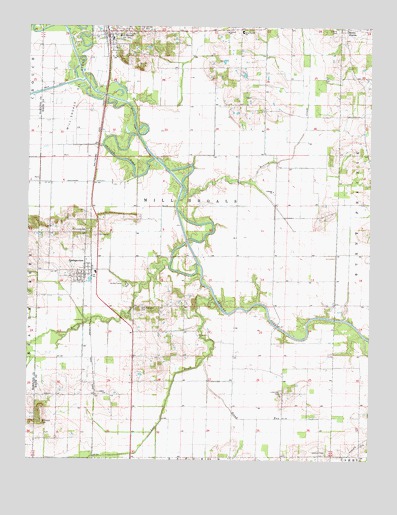
Springerton, IL USGS Topographic Map
Click on map above to begin viewing in our Map Viewer.

This topographic map contains these locations and features:
Feature Name Type Latitude Longitude GNIS ID View Map
Antioch ChurchChurchN38.2487°W88.3031°403553View Map
Asbury ChurchChurchN38.1439°W88.3464°403652View Map
Ashland ChurchChurchN38.2028°W88.2859°403671View Map
Ashland School (historical)SchoolN38.1987°W88.2917°1705603View Map
Beaver CreekStreamN38.1814°W88.3234°404054View Map
Broad RunStreamN38.1539°W88.3103°404883View Map
Crossroads School (historical)SchoolN38.1770°W88.2850°1705605View Map
Fairfield Rural Fire Protection District SubstationBuildingN38.2494°W88.3464°2682530View Map
Fairview Church (historical)ChurchN38.2381°W88.3192°1705606View Map
Fleck School (historical)SchoolN38.1517°W88.2906°1705607View Map
Hammack CemeteryCemeteryN38.1909°W88.3534°409710View Map
Jacobs CampLocaleN38.1756°W88.3395°411017View Map
Johnson CemeteryCemeteryN38.1275°W88.2656°411150View Map
Kitty Sweeten CemeteryCemeteryN38.1687°W88.3342°411559View Map
Liberty CemeteryCemeteryN38.2492°W88.2625°411985View Map
Little Zion CemeteryCemeteryN38.1442°W88.2820°412439View Map
Little Zion Church (historical)ChurchN38.1437°W88.2817°1705609View Map
Lone Oak School (historical)SchoolN38.2245°W88.2620°1705610View Map
Lost CreekStreamN38.1709°W88.3064°412646View Map
McIntosh School (historical)SchoolN38.2231°W88.3664°1705612View Map
McIntosh Settlement (historical)Populated PlaceN38.2156°W88.3625°1705611View Map
McLntosh CemeteryCemeteryN38.1359°W88.3695°413323View Map
Mill ShoalsPopulated PlaceN38.2487°W88.3467°413558View Map
Mill Shoals Oil FieldOilfieldN38.2378°W88.3587°425197View Map
Mill Shoals Post OfficePost OfficeN38.2456°W88.3462°2788729View Map
Mills Prairie SchoolSchoolN38.2489°W88.2978°413622View Map
Nubbin Ridge School (historical)SchoolN38.1617°W88.3234°1705615View Map
Pleasant Valley School (historical)SchoolN38.1339°W88.2537°1705616View Map
Prairie CreekStreamN38.2020°W88.3178°416120View Map
Satisfaction School (historical)SchoolN38.1945°W88.3262°1705617View Map
Springer StationPopulated PlaceN38.1798°W88.3517°1705619View Map
SpringertonPopulated PlaceN38.1795°W88.3542°419003View Map
Springerton CemeteryCemeteryN38.1787°W88.3595°1823981View Map
Springerton Post OfficePost OfficeN38.1786°W88.3545°2788230View Map
Township of Mill ShoalsCivilN38.1910°W88.3167°429369View Map
Union School (historical)SchoolN38.2128°W88.3078°1705623View Map
Village of Mill ShoalsCivilN38.2494°W88.3456°2399348View Map
Village of SpringertonCivilN38.1787°W88.3547°2399879View Map
West Antioch CemeteryCemeteryN38.2481°W88.3031°1823986View Map
White School (historical)SchoolN38.2389°W88.2892°1705627View Map
Wildcat School (historical)SchoolN38.1942°W88.3537°1705628View Map

Note: Coordinates in the location and feature list above are referenced to NAD83 datum.


Copyright (C) 2008-2024 Ryan Niemi / Sunset Dynamics ... All Rights Reserved