TopoQuest Logo
Do you find TopoQuest useful?
Help keep TopoQuest running and adding new maps/features by donating!
Bitcoin:  19c7KJd3qBynnjoSw5npx9KScwjBe4ifkT
Litecoin:  LXs6TkuXGGXo1vDsWCkWVdjQX94eUKd6ui
Home View Maps Find Maps Find Places Resources & Links


Spring Lake, Wisconsin Topographic Map

USGS Map Title: Spring Lake, WI
USGS Map MRC: 44089A2
DRG (GeoTIFF) Download: o44089a2.tif


Neighboring USGS Topographic Map Quads:


  Wautoma NE, WI  
44089B3
 

  Wild Rose, WI  
44089B2
 

  Saxeville, WI  
44089B1
 

  Wautoma, WI  
44089A3
 

  Spring Lake, WI  
44089A2
 

  Redgranite, WI  
44089A1
 

  Germania, WI  
43089H3
 

  Neshkoro, WI  
43089H2
 

  Fairburn, WI  
43089H1


Map MRC Location:

N45°
W90°
N45°
W89°
H8 H7 H6 H5 H4 H3 H2 H1
G8 G7 G6 G5 G4 G3 G2 G1
F8 F7 F6 F5 F4 F3 F2 F1
E8 E7 E6 E5 E4 E3 E2 E1
D8 D7 D6 D5 D4 D3 D2 D1
C8 C7 C6 C5 C4 C3 C2 C1
B8 B7 B6 B5 B4 B3 B2 B1
A8 A7 A6 A5 A4 A3 A2 A1
N44°
W90°
N44°
W89°

Spring Lake, WI USGS 1:24K Topographic Map Preview:
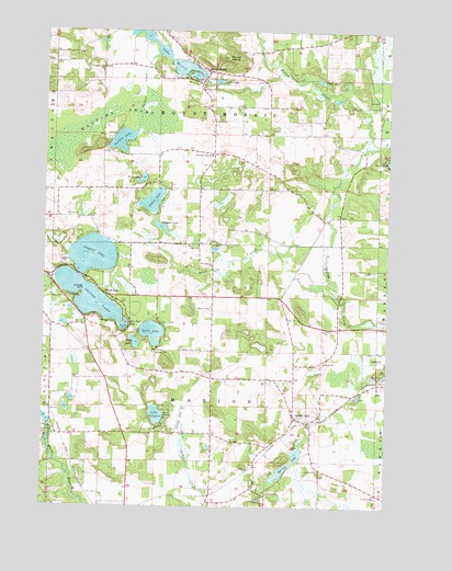
Spring Lake, WI USGS Topographic Map
Click on map above to begin viewing in our Map Viewer.

This topographic map contains these locations and features:
Feature Name Type Latitude Longitude GNIS ID View Map
Alpine Lake 3WR471 DamDamN44.0616°W89.1901°1791774View Map
Alpine Lake 4ReservoirN44.0605°W89.1942°1791775View Map
Bruce CreekStreamN44.0536°W89.1421°1562280View Map
Camp LucerneLocaleN44.0216°W89.2046°1562631View Map
Chicago PointCapeN44.0558°W89.2365°1563004View Map
Cooks LakeLakeN44.1119°W89.1500°1563348View Map
Deer LakeLakeN44.0430°W89.2168°1563833View Map
Emerald LakeLakeN44.1132°W89.1960°1564612View Map
Fish Lake 2WP6 DamDamN44.0600°W89.2368°1792815View Map
Fish Lake 5ReservoirN44.0600°W89.2368°1792816View Map
Fox Tail BayBayN44.0475°W89.2196°1565235View Map
Fox Tail PointCapeN44.0478°W89.2210°1565236View Map
Hills LakeLakeN44.0457°W89.2105°1566445View Map
Holden ChurchChurchN44.1011°W89.1885°1566542View Map
Irogami LakeLakeN44.0659°W89.2324°1566962View Map
Johns LakeLakeN44.0803°W89.2108°1567206View Map
Lake LucerneLakeN44.0240°W89.2087°1568781View Map
Lake MorrisReservoirN44.1187°W89.2060°1791841View Map
Little LakeLakeN44.1118°W89.1875°1568298View Map
Lower White River WP271 DamDamN44.0200°W89.2485°1791772View Map
Marion CemeteryCemeteryN44.0522°W89.1887°1569043View Map
Marion Town Police DepartmentBuildingN44.0260°W89.1589°2759953View Map
Mount MorrisSummitN44.1180°W89.1846°1569753View Map
Mount MorrisPopulated PlaceN44.1144°W89.1907°1569821View Map
Mount Morris 3WR1972 DamDamN44.1133°W89.1935°1791840View Map
Mountain View SchoolSchoolN44.0930°W89.1896°1569871View Map
Oakridge Mennonite SchoolSchoolN44.0678°W89.1412°2716859View Map
Plantation Pine AirportAirportN44.0566°W89.1399°1582172View Map
Porters CreekStreamN44.1189°W89.2098°1571808View Map
Porters LakeLakeN44.0962°W89.2224°1571809View Map
Silver LakeLakeN44.0548°W89.2339°1574133View Map
Silver LakePopulated PlaceN44.0553°W89.2262°1574151View Map
Spring Creek AirportAirportN44.0230°W89.1385°1582218View Map
Spring LakeLakeN44.0111°W89.1607°1574665View Map
Spring LakePopulated PlaceN44.0233°W89.1587°1574683View Map
Squaw LakeLakeN44.0480°W89.2429°2784727View Map
Tippetts LakeLakeN44.0735°W89.2080°1575471View Map
Town of MarionCivilN44.0258°W89.1879°1583658View Map
Town of Mount MorrisCivilN44.1123°W89.1879°1583765View Map
Twin LakesLakeN44.0864°W89.2143°1575794View Map
Waushara CountyCivilN44.1131°W89.2429°1581128View Map
Wautoma SwampSwampN44.0989°W89.2343°1576333View Map
White River FlowageReservoirN44.0205°W89.2479°1576657View Map

Note: Coordinates in the location and feature list above are referenced to NAD83 datum.


Copyright (C) 2008-2024 Ryan Niemi / Sunset Dynamics ... All Rights Reserved