TopoQuest Logo
Do you find TopoQuest useful?
Help keep TopoQuest running and adding new maps/features by donating!
Bitcoin:  19c7KJd3qBynnjoSw5npx9KScwjBe4ifkT
Litecoin:  LXs6TkuXGGXo1vDsWCkWVdjQX94eUKd6ui
Home View Maps Find Maps Find Places Resources & Links


Spicer Peak, Colorado Topographic Map

USGS Map Title: Spicer Peak, CO
USGS Map MRC: 40106D4
DRG (GeoTIFF) Download: o40106d4.tif


Neighboring USGS Topographic Map Quads:


  Teal Lake, CO  
40106E5
 

  Coalmont, CO  
40106E4
 

  MacFarlane Reservoir, CO  
40106E3
 

  Rabbit Ears Peak, CO  
40106D5
 

  Spicer Peak, CO  
40106D4
 

  Buffalo Peak, CO  
40106D3
 

  Lake Agnes, CO  
40106C5
 

  Whiteley Peak, CO  
40106C4
 

  Hyannis Peak, CO  
40106C3


Map MRC Location:

N41°
W107°
N41°
W106°
H8 H7 H6 H5 H4 H3 H2 H1
G8 G7 G6 G5 G4 G3 G2 G1
F8 F7 F6 F5 F4 F3 F2 F1
E8 E7 E6 E5 E4 E3 E2 E1
D8 D7 D6 D5 D4 D3 D2 D1
C8 C7 C6 C5 C4 C3 C2 C1
B8 B7 B6 B5 B4 B3 B2 B1
A8 A7 A6 A5 A4 A3 A2 A1
N40°
W107°
N40°
W106°

Spicer Peak, CO USGS 1:24K Topographic Map Preview:
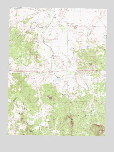
Spicer Peak, CO USGS Topographic Map
Click on map above to begin viewing in our Map Viewer.

This topographic map contains these locations and features:
Feature Name Type Latitude Longitude GNIS ID View Map
Arapaho CreekStreamN40.4691°W106.4586°172806View Map
Arapaho DitchCanalN40.4694°W106.4336°172807View Map
Arapaho DitchCanalN40.4419°W106.4150°172815View Map
Arapaho PassGapN40.3850°W106.4725°172795View Map
Bailey RanchLocaleN40.4594°W106.4770°172802View Map
Chas Murphy RanchLocaleN40.4694°W106.4409°172818View Map
Coyte DamDamN40.4833°W106.4273°199974View Map
Coyte ReservoirReservoirN40.4833°W106.4273°199975View Map
Dennis HumpCliffN40.3905°W106.4195°172800View Map
Ed Van DrawValleyN40.4803°W106.4635°172811View Map
Eureka DitchCanalN40.4750°W106.4006°202084View Map
Experiment DitchCanalN40.4208°W106.4389°2712027View Map
F P Murphy RanchLocaleN40.4661°W106.4625°172804View Map
Hecla DamDamN40.4622°W106.4078°201164View Map
Hecla ReservoirReservoirN40.4622°W106.4078°172820View Map
Horseshoe Bend DrawValleyN40.4351°W106.4969°172801View Map
Indian CreekStreamN40.4439°W106.4395°172821View Map
Ironclad MountainSummitN40.4097°W106.4434°172798View Map
Jordan DitchCanalN40.4361°W106.4373°172794View Map
Kidney LakeLakeN40.4319°W106.4423°172853View Map
Koping DitchCanalN40.4944°W106.4400°202082View Map
Larsen DitchCanalN40.4778°W106.4636°172810View Map
Lawrence Number 1 DitchCanalN40.4472°W106.4495°172793View Map
Little Haystack MountainSummitN40.3797°W106.3809°172799View Map
Martin DitchCanalN40.4955°W106.4617°172813View Map
Mexican Creek DamDamN40.4989°W106.4920°199986View Map
Mexican ReservoirReservoirN40.4990°W106.4943°202109View Map
Middle Fork Arapaho CreekStreamN40.4153°W106.3900°172824View Map
Middle Fork Mexican CreekStreamN40.4997°W106.4964°172791View Map
Murphy Desert RanchLocaleN40.4830°W106.4148°172817View Map
Ninegar CreekStreamN40.4303°W106.4020°172825View Map
Seymour DamDamN40.4800°W106.3906°199998View Map
Seymour Ditch Number 1CanalN40.4854°W106.4568°2724202View Map
Seymour Ditch Number 2CanalN40.4833°W106.4511°172809View Map
Seymour LakeReservoirN40.4800°W106.3906°199999View Map
South Arapaho ReservoirReservoirN40.4156°W106.4258°172796View Map
South Fork Arapaho CreekStreamN40.4153°W106.3900°172823View Map
South Fork Mexican CreekStreamN40.4972°W106.4603°172790View Map
SpicerLocaleN40.4666°W106.4561°172803View Map
Spicer PeakSummitN40.4455°W106.3961°172819View Map
Surprise DitchCanalN40.4805°W106.4264°172816View Map
Titantic DitchCanalN40.4250°W106.4106°172792View Map
Van Valkenburg DamDamN40.4858°W106.4650°201148View Map
Van Valkenburg RanchLocaleN40.4836°W106.4639°172805View Map
Van Valkenburg ReservoirReservoirN40.4851°W106.4653°172812View Map
Wade DamDamN40.4733°W106.3789°201720View Map
Wade LakeReservoirN40.4721°W106.3787°201721View Map
Waste DitchCanalN40.4750°W106.4520°172808View Map
West Arapaho ReservoirReservoirN40.4304°W106.4360°172797View Map
West Arapahoe DamDamN40.4333°W106.4323°201430View Map
West Arapahoe Feeder DitchCanalN40.4266°W106.4223°2724478View Map
West Arapahoe Feeder Ditch Number 2CanalN40.4333°W106.4466°2724479View Map
West Home RanchLocaleN40.4908°W106.4436°172814View Map

Note: Coordinates in the location and feature list above are referenced to NAD83 datum.


Copyright (C) 2008-2024 Ryan Niemi / Sunset Dynamics ... All Rights Reserved