TopoQuest Logo
Do you find TopoQuest useful?
Help keep TopoQuest running and adding new maps/features by donating!
Bitcoin:  19c7KJd3qBynnjoSw5npx9KScwjBe4ifkT
Litecoin:  LXs6TkuXGGXo1vDsWCkWVdjQX94eUKd6ui
Home View Maps Find Maps Find Places Resources & Links


Blackrock, California Topographic Map

USGS Map Title: Blackrock, CA
USGS Map MRC: 36118H2
DRG (GeoTIFF) Download: o36118h2.tif


Neighboring USGS Topographic Map Quads:


  Fish Springs, CA  
37118A3
 

  Tinemaha Reservoir, CA  
37118A2
 

  Waucoba Mountain, CA  
37118A1
 

  Aberdeen, CA  
36118H3
 

  Blackrock, CA  
36118H2
 

  Mazourka Peak, CA  
36118H1
 

  Kearsarge Peak, CA  
36118G3
 

  Independence, CA  
36118G2
 

  Bee Springs Canyon, CA  
36118G1


Map MRC Location:

N37°
W119°
N37°
W118°
H8 H7 H6 H5 H4 H3 H2 H1
G8 G7 G6 G5 G4 G3 G2 G1
F8 F7 F6 F5 F4 F3 F2 F1
E8 E7 E6 E5 E4 E3 E2 E1
D8 D7 D6 D5 D4 D3 D2 D1
C8 C7 C6 C5 C4 C3 C2 C1
B8 B7 B6 B5 B4 B3 B2 B1
A8 A7 A6 A5 A4 A3 A2 A1
N36°
W119°
N36°
W118°

Blackrock, CA USGS 1:24K Topographic Map Preview:
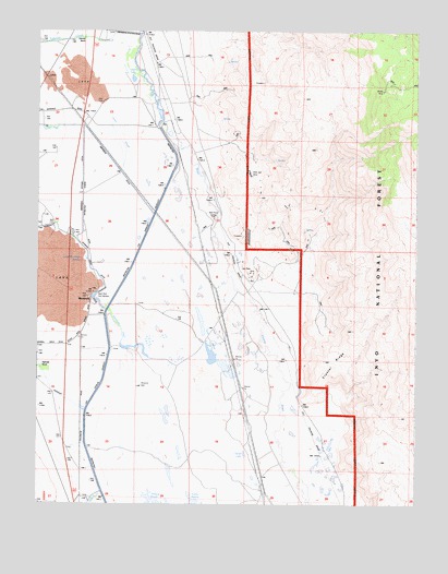
Blackrock, CA USGS Topographic Map
Click on map above to begin viewing in our Map Viewer.

This topographic map contains these locations and features:
Feature Name Type Latitude Longitude GNIS ID View Map
Aberdeen Bypass DitchCanalN36.9616°W118.2362°1667205View Map
Aberdeen DitchCanalN36.9647°W118.2259°256099View Map
Black Jack MineMineN36.9624°W118.1812°1667210View Map
Black Rock Fish HatcheryLocaleN36.9299°W118.2320°1667211View Map
BlackrockPopulated PlaceN36.9291°W118.2334°1667212View Map
Blackrock DrainStreamN36.9260°W118.2279°1667213View Map
Blackrock SpringsSpringN36.9297°W118.2337°257175View Map
Blue Boy ProspectMineN36.9574°W118.1779°1804667View Map
California Rose Number 2 ProspectMineN36.9577°W118.1540°1804669View Map
Calvert LakeLakeN36.9870°W118.2197°1667214View Map
Chrysopolis (historical)Populated PlaceN36.9605°W118.1968°1804671View Map
Crystal RidgeRidgeN36.9122°W118.1545°1667217View Map
Division Creek DitchCanalN36.9424°W118.2354°257173View Map
Elkhorn Numbers 1-8 Placer MinesMineN36.8933°W118.1315°1804675View Map
Empire MineMineN36.9019°W118.1398°1804676View Map
Eureka Consolidated Quartz MineMineN36.9455°W118.1823°1804677View Map
George III ProspectMineN36.9533°W118.1595°1804679View Map
Gold Bugs Numbers 1-2 ProspectsMineN36.9591°W118.1626°1804680View Map
Goodale CreekStreamN36.9749°W118.2351°260694View Map
Goose LakeLakeN36.8880°W118.1820°260707View Map
Green Group ProspectsMineN36.9424°W118.1770°1804684View Map
Hines SloughStreamN36.9633°W118.2237°1667223View Map
Hines SpringSpringN36.9785°W118.2295°261365View Map
Iron Wedge ProspectMineN36.9630°W118.1576°1804688View Map
Jack Black MineMineN36.9369°W118.1793°261848View Map
Johnnie Number 7 ProspectMineN36.9722°W118.1545°1804691View Map
Little Blackrock SpringSpringN36.9391°W118.2365°262545View Map
Little Joker ProspectMineN36.9863°W118.1768°1804693View Map
Lucky Larry Group ProspectsMineN36.9413°W118.1670°1804695View Map
Manlan Numbers 1-9 ProspectsMineN36.9538°W118.1690°1804697View Map
Maxim Mill (historical)LocaleN36.9602°W118.1976°1804698View Map
Mendosino MineMineN36.9019°W118.1368°1804699View Map
Monte Cristo ProspectMineN36.9738°W118.1712°1804702View Map
Old River Arrastre-Black Jack Gold Numbers 1-10 ProspectsMineN36.9669°W118.1826°1804704View Map
Old River Arrastre-Owl ProspectMineN36.9605°W118.1779°1804705View Map
Pyrite Extension ProspectMineN36.9527°W118.1579°1804710View Map
Sawmill CreekStreamN36.8997°W118.2354°232614View Map
Sixtynine Numbers 1-6 ProspectsMineN36.9874°W118.1901°1804714View Map
Squaw MineMineN36.9844°W118.1373°1667256View Map
Taboose CreekStreamN36.9997°W118.2170°268057View Map
Taboose RanchLocaleN36.9983°W118.2365°268059View Map
Thibaut CreekStreamN36.8783°W118.2295°266359View Map
Thibaut PondsLakeN36.8762°W118.2142°1667258View Map
Twin LakesLakeN36.9212°W118.1963°1667262View Map
Winerton WellWellN36.9063°W118.2168°1667265View Map

Note: Coordinates in the location and feature list above are referenced to NAD83 datum.


Copyright (C) 2008-2024 Ryan Niemi / Sunset Dynamics ... All Rights Reserved