TopoQuest Logo
Do you find TopoQuest useful?
Help keep TopoQuest running and adding new maps/features by donating!
Bitcoin:  19c7KJd3qBynnjoSw5npx9KScwjBe4ifkT
Litecoin:  LXs6TkuXGGXo1vDsWCkWVdjQX94eUKd6ui
Home View Maps Find Maps Find Places Resources & Links


Southwest Albion, Michigan Topographic Map

USGS Map Title: Southwest Albion, MI
USGS Map MRC: 42084B7
DRG (GeoTIFF) Download: o42084b7.tif


Neighboring USGS Topographic Map Quads:


  Marshall, MI  
42084C8
 

  Northwest Albion, MI  
42084C7
 

  Northeast Albion, MI  
42084C6
 

  Lyon Lake, MI  
42084B8
 

  Southwest Albion, MI  
42084B7
 

  Southeast Albion, MI  
42084B6
 

  Tekonsha, MI  
42084A8
 

  Litchfield, MI  
42084A7
 

  Mosherville, MI  
42084A6


Map MRC Location:

N43°
W85°
N43°
W84°
H8 H7 H6 H5 H4 H3 H2 H1
G8 G7 G6 G5 G4 G3 G2 G1
F8 F7 F6 F5 F4 F3 F2 F1
E8 E7 E6 E5 E4 E3 E2 E1
D8 D7 D6 D5 D4 D3 D2 D1
C8 C7 C6 C5 C4 C3 C2 C1
B8 B7 B6 B5 B4 B3 B2 B1
A8 A7 A6 A5 A4 A3 A2 A1
N42°
W85°
N42°
W84°

Southwest Albion, MI USGS 1:24K Topographic Map Preview:
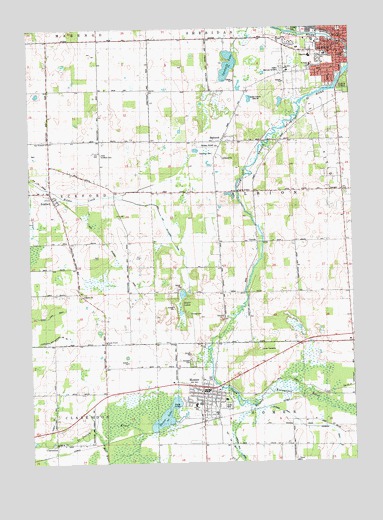
Southwest Albion, MI USGS Topographic Map
Click on map above to begin viewing in our Map Viewer.

This topographic map contains these locations and features:
Feature Name Type Latitude Longitude GNIS ID View Map
AlbionPopulated PlaceN42.2431°W84.7530°619906View Map
Albion City HallBuildingN42.2453°W84.7539°2629262View Map
Albion City Police DepartmentBuildingN42.2455°W84.7540°2629263View Map
Albion Department of Public Safety Fire StationBuildingN42.2455°W84.7540°2629264View Map
Albion Memory GardensCemeteryN42.2384°W84.7758°619907View Map
Albion Post OfficePost OfficeN42.2472°W84.7536°2629253View Map
Albion Public LibraryBuildingN42.2419°W84.7528°2629256View Map
Albion StationLocaleN42.2472°W84.7558°2629266View Map
Albion Township CemeteryCemeteryN42.2142°W84.8033°2630245View Map
Albion Township Fire DepartmentBuildingN42.2034°W84.7528°2636014View Map
Andrus DrainCanalN42.1387°W84.8669°620120View Map
BabcockPopulated PlaceN42.2173°W84.8000°620399View Map
Babcock CemeteryCemeteryN42.2178°W84.7994°2630244View Map
Ball and Patterson DrainCanalN42.1931°W84.8222°620522View Map
Benham DrainCanalN42.1395°W84.7786°621096View Map
Bethel Baptist ChurchChurchN42.2458°W84.7603°2629237View Map
Camp TanawidaLocaleN42.1573°W84.7866°622642View Map
Caring Community Wesleyan ChurchChurchN42.2372°W84.7731°2629243View Map
Champion DrainCanalN42.1275°W84.7586°623056View Map
Christ Apostolic ChurchChurchN42.2486°W84.7533°2629238View Map
Church of GodChurchN42.2361°W84.7575°2629245View Map
City of AlbionCivilN42.2478°W84.7572°1625813View Map
ClarendonPopulated PlaceN42.1303°W84.8658°1623729View Map
Clarendon Post Office (historical)Post OfficeN42.1303°W84.8658°2630173View Map
Clarendon Station (historical)LocaleN42.1283°W84.8656°2630060View Map
ConditPopulated PlaceN42.1884°W84.7866°623686View Map
Cook's Prairie CemeteryCemeteryN42.1564°W84.8461°2630233View Map
Cooks Prairie ChurchChurchN42.1603°W84.8461°623759View Map
Dalrymple SchoolSchoolN42.2425°W84.7597°624287View Map
East Chestnut Street ChurchChurchN42.2492°W84.7514°2629240View Map
East Eckford CemeteryCemeteryN42.2139°W84.8469°625178View Map
East Eckford ChurchChurchN42.2175°W84.8675°625179View Map
EckfordPopulated PlaceN42.2020°W84.8664°625335View Map
Eckford Post Office (historical)Post OfficeN42.2019°W84.8664°2630169View Map
Eckford Station (historical)LocaleN42.2031°W84.8667°2630058View Map
Fairview CemeteryCemeteryN42.1542°W84.8139°625763View Map
Faith Community Baptist ChurchChurchN42.2419°W84.7528°2629235View Map
Family Health Center of AlbionHospitalN42.2450°W84.7525°2629249View Map
First Presbyterian Church Historical MarkerParkN42.1436°W84.8075°2628097View Map
Fletcher SchoolSchoolN42.1417°W84.8122°626166View Map
Gardner House MuseumBuildingN42.2417°W84.7528°2629250View Map
Gardner House Museum Historical MarkerParkN42.2420°W84.7530°2628055View Map
HomerPopulated PlaceN42.1459°W84.8089°628509View Map
Homer Community High SchoolSchoolN42.1422°W84.8094°2630091View Map
Homer Fire DepartmentBuildingN42.1459°W84.8061°2630088View Map
Homer Fire Station Historical MarkerParkN42.1456°W84.8066°2628098View Map
Homer LakeLakeN42.1384°W84.8233°628512View Map
Homer Medical CenterHospitalN42.1419°W84.8083°2630090View Map
Homer Police DepartmentBuildingN42.1458°W84.8064°2737636View Map
Homer Post OfficePost OfficeN42.1458°W84.8072°2630083View Map
Homer Public LibraryBuildingN42.1456°W84.8078°2630089View Map
Homer Station (historical)LocaleN42.1406°W84.8042°2630082View Map
Kesler LakeLakeN42.1736°W84.8161°629626View Map
Kids 'N' Stuff MuseumBuildingN42.2439°W84.7531°2629252View Map
Midway Airport (historical)AirportN42.2159°W84.8090°1623771View Map
Mother's Day in Albion Historical MarkerParkN42.2425°W84.7510°2628057View Map
New Village Estates Mobile Home ParkPopulated PlaceN42.1406°W84.8000°2630087View Map
Old Homer Cemetery (historical)CemeteryN42.1408°W84.8061°2630229View Map
Presbyterian ChurchChurchN42.1433°W84.8083°2630085View Map
Rieger ParkParkN42.2417°W84.7508°2629260View Map
Riverside Baptist ChurchChurchN42.1483°W84.8008°2630084View Map
Riverside CemeteryCemeteryN42.2336°W84.7525°635983View Map
Riverside Cemetery Historical MarkerParkN42.2349°W84.7534°2628060View Map
Saint James Episcopal ChurchChurchN42.2428°W84.7542°2629236View Map
Saint John Catholic ChurchChurchN42.2375°W84.7739°2629232View Map
Saint Johns SchoolSchoolN42.2381°W84.7739°636749View Map
Saint Pauls ChurchChurchN42.2398°W84.7650°637002View Map
Salem United Church of ChristChurchN42.2497°W84.7536°2629239View Map
Spectacle LakeLakeN42.2393°W84.7971°638487View Map
The Observatory Historical MarkerParkN42.2448°W84.7534°2628059View Map
Township of AlbionCivilN42.2005°W84.7717°1625814View Map
United Methodist ChurchChurchN42.1444°W84.8069°2630086View Map
Victory ChurchChurchN42.1589°W84.8080°1615577View Map
Village of HomerCivilN42.1461°W84.8103°2398533View Map
WALM-AM (Albion)TowerN42.2300°W84.7886°1625146View Map

Note: Coordinates in the location and feature list above are referenced to NAD83 datum.


Copyright (C) 2008-2024 Ryan Niemi / Sunset Dynamics ... All Rights Reserved