TopoQuest Logo
Do you find TopoQuest useful?
Help keep TopoQuest running and adding new maps/features by donating!
Bitcoin:  19c7KJd3qBynnjoSw5npx9KScwjBe4ifkT
Litecoin:  LXs6TkuXGGXo1vDsWCkWVdjQX94eUKd6ui
Home View Maps Find Maps Find Places Resources & Links


Southeast Lumberton, North Carolina Topographic Map

USGS Map Title: Southeast Lumberton, NC
USGS Map MRC: 34078E8
DRG (GeoTIFF) Download: o34078e8.tif


Neighboring USGS Topographic Map Quads:


  Northwest Lumberton, NC  
34079F1
 

  Northeast Lumberton, NC  
34078F8
 

  Tar Heel, NC  
34078F7
 

  Southwest Lumberton, NC  
34079E1
 

  Southeast Lumberton, NC  
34078E8
 

  Bladenboro, NC  
34078E7
 

  Fairmont, NC  
34079D1
 

  Evergreen, NC  
34078D8
 

  Chadbourn NE, NC  
34078D7


Map MRC Location:

N35°
W79°
N35°
W78°
H8 H7 H6 H5 H4 H3 H2 H1
G8 G7 G6 G5 G4 G3 G2 G1
F8 F7 F6 F5 F4 F3 F2 F1
E8 E7 E6 E5 E4 E3 E2 E1
D8 D7 D6 D5 D4 D3 D2 D1
C8 C7 C6 C5 C4 C3 C2 C1
B8 B7 B6 B5 B4 B3 B2 B1
A8 A7 A6 A5 A4 A3 A2 A1
N34°
W79°
N34°
W78°

Southeast Lumberton, NC USGS 1:24K Topographic Map Preview:
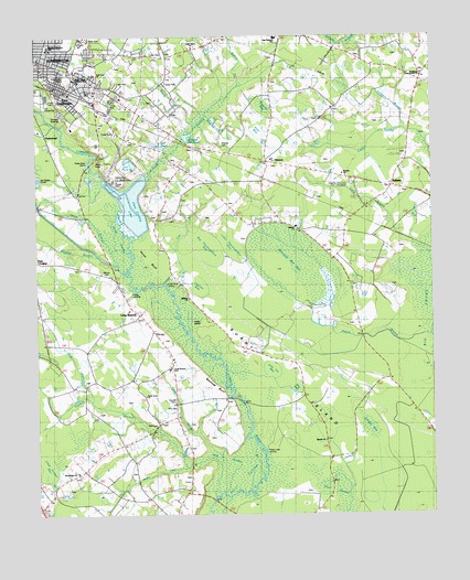
Southeast Lumberton, NC USGS Topographic Map
Click on map above to begin viewing in our Map Viewer.

This topographic map contains these locations and features:
Feature Name Type Latitude Longitude GNIS ID View Map
AllentonPopulated PlaceN34.5924°W78.9261°1018799View Map
Allenton Volunteer Fire DepartmentBuildingN34.5921°W78.9233°2639440View Map
Antioch ChurchChurchN34.5754°W78.9181°980211View Map
Ash PondReservoirN34.5918°W78.9692°1003780View Map
Bear BayBayN34.5824°W78.9195°980688View Map
Bee BranchStreamN34.5285°W78.9795°980882View Map
BellamyPopulated PlaceN34.5857°W78.8875°1003846View Map
Beulah ChurchChurchN34.5193°W78.9092°981259View Map
Big BayBasinN34.5329°W78.9178°1025020View Map
Big Branch CanalCanalN34.5096°W78.9670°1025146View Map
Big Thoroughfare BayBasinN34.5721°W78.9464°1025023View Map
Blounts BaySwampN34.5977°W78.9303°981614View Map
Blounts BranchStreamN34.6041°W78.9467°981615View Map
Bog BaySwampN34.5824°W78.8839°981676View Map
Britt CemeteryCemeteryN34.5235°W78.9622°1003772View Map
Britt CemeteryCemeteryN34.5280°W78.9560°1003774View Map
Britts Township Volunteer Fire DepartmentBuildingN34.5477°W78.9623°2638706View Map
Broadridge ChurchChurchN34.5110°W78.9867°981952View Map
Burnt IslandIslandN34.5371°W78.9200°982297View Map
Cedar Grove ChurchChurchN34.6221°W78.9495°982833View Map
Charles BayBasinN34.5596°W78.9506°1025029View Map
Cooling Lake DamDamN34.5818°W78.9731°998100View Map
Country Side Mobile Home ParkPopulated PlaceN34.6001°W78.9754°2505441View Map
Cox BranchStreamN34.5693°W78.9559°1025266View Map
Cypress BaySwampN34.5088°W78.8870°983870View Map
East LumbertonPopulated PlaceN34.6104°W78.9923°1020085View Map
East Robeson SchoolSchoolN34.6246°W78.9239°1003782View Map
Gabriel BaySwampN34.5241°W78.9192°985509View Map
Gum SwampSwampN34.5091°W78.9081°1025362View Map
HestertownPopulated PlaceN34.5977°W78.9956°1020693View Map
Hillburn BranchStreamN34.6010°W78.8839°986802View Map
Hollywood CemeteryCemeteryN34.6141°W78.9889°986967View Map
Horse BluffFlatN34.5677°W78.9639°1025398View Map
Horse Bluff LandingLocaleN34.5607°W78.9595°1003775View Map
Hyde Park ChurchChurchN34.6154°W78.9811°1003779View Map
Indigo IslandIslandN34.5482°W78.9486°987372View Map
Jacob BranchStreamN34.5649°W78.9734°979991View Map
Jacob SwampStreamN34.5727°W78.9681°1025422View Map
Jacob SwampSwampN34.5732°W78.9736°1025423View Map
Janie C Hargrave Elementary SchoolSchoolN34.6138°W78.9870°1003778View Map
Jess Ivy BayBasinN34.5363°W78.9250°1025040View Map
Juniper BayBasinN34.5221°W78.8956°1025041View Map
Lawson CemeteryCemeteryN34.5298°W78.9564°1003773View Map
Lee PondReservoirN34.5963°W78.9602°988302View Map
Lennon PondReservoirN34.5525°W78.9129°988351View Map
Little Juniper BaySwampN34.5138°W78.9967°988684View Map
Little Thoroughfare BayBasinN34.5718°W78.9381°1025044View Map
Long BranchStreamN34.5052°W78.9428°1025493View Map
Long BranchStreamN34.5741°W78.8853°988888View Map
Long BranchPopulated PlaceN34.5535°W78.9692°1003776View Map
Long BranchStreamN34.5007°W78.8759°988921View Map
Long Branch ChurchChurchN34.5532°W78.9703°988931View Map
Long Branch SchoolSchoolN34.5371°W78.9578°988936View Map
Lumberton Fire Department Station 2BuildingN34.6056°W78.9810°2638166View Map
Lumberton Police Department East SubstationBuildingN34.6153°W78.9865°2769815View Map
Lumberton Wastewater Treatment PlantLocaleN34.6046°W78.9914°2506009View Map
Matthew BluffCliffN34.5346°W78.9445°989470View Map
Midway ChurchChurchN34.5563°W78.9523°989820View Map
Mill SwampSwampN34.5152°W78.9425°989987View Map
Panther BaySwampN34.5854°W78.9548°991819View Map
Panther BranchStreamN34.5677°W78.9795°980004View Map
Peters BranchStreamN34.5471°W78.8761°992083View Map
Peters Lake LandingLocaleN34.5171°W78.9284°1021875View Map
Peters SwampSwampN34.5527°W78.9297°992093View Map
Phillips Mobile Home ParkPopulated PlaceN34.5877°W78.9503°2505544View Map
Pigeon BaySwampN34.5010°W78.9259°992180View Map
Pine BayBasinN34.5991°W78.9286°1025049View Map
Pinks BaySwampN34.5910°W78.9370°992402View Map
Plant Cooling LakeReservoirN34.5810°W78.9692°998099View Map
Pope CrossingPopulated PlaceN34.5663°W78.9978°1022033View Map
Popes LandingLocaleN34.5563°W78.9711°1022035View Map
Popular BayBasinN34.6082°W78.9272°1025050View Map
Reedy BranchStreamN34.6007°W78.9500°993168View Map
River SwampSwampN34.5093°W78.9348°993377View Map
Robeson Memorial ParkCemeteryN34.5860°W78.9006°1007473View Map
Rowland Norment Elementary SchoolSchoolN34.6224°W78.9954°993778View Map
Singletary Cross Roads ChurchChurchN34.6152°W78.8781°994863View Map
Smyrna ChurchChurchN34.5893°W78.9031°995026View Map
Stone Grove ChurchChurchN34.5307°W78.9653°995532View Map
Tenmile BranchStreamN34.5127°W78.9528°995925View Map
Thorofare SwampSwampN34.5704°W78.9525°996072View Map
Township of BrittsCivilN34.5240°W78.9695°1027103View Map
Township of WishartsCivilN34.5624°W78.9046°1027129View Map
Warwick Mill BayBasinN34.5674°W78.9195°1025059View Map
Warwick Mill PondReservoirN34.5989°W78.9521°996818View Map
West Mobile Home ParkPopulated PlaceN34.6117°W78.9730°2505687View Map
Wilcox CemeteryCemeteryN34.5629°W78.9779°1026241View Map
Wilson BranchStreamN34.6129°W78.9336°997434View Map
Wishart CemeteryCemeteryN34.5971°W78.9409°1003781View Map

Note: Coordinates in the location and feature list above are referenced to NAD83 datum.


Copyright (C) 2008-2024 Ryan Niemi / Sunset Dynamics ... All Rights Reserved