TopoQuest Logo
Do you find TopoQuest useful?
Help keep TopoQuest running and adding new maps/features by donating!
Bitcoin:  19c7KJd3qBynnjoSw5npx9KScwjBe4ifkT
Litecoin:  LXs6TkuXGGXo1vDsWCkWVdjQX94eUKd6ui
Home View Maps Find Maps Find Places Resources & Links


Sonora, Arkansas Topographic Map

USGS Map Title: Sonora, AR
USGS Map MRC: 36094B1
DRG (GeoTIFF) Download: o36094b1.tif


Neighboring USGS Topographic Map Quads:


  Bentonville South, AR  
36094C2
 

  Rogers, AR  
36094C1
 

  War Eagle, AR  
36093C8
 

  Springdale, AR  
36094B2
 

  Sonora, AR  
36094B1
 

  Spring Valley, AR  
36093B8
 

  Fayetteville, AR  
36094A2
 

  Elkins, AR  
36094A1
 

  Goshen, AR  
36093A8


Map MRC Location:

N37°
W95°
N37°
W94°
H8 H7 H6 H5 H4 H3 H2 H1
G8 G7 G6 G5 G4 G3 G2 G1
F8 F7 F6 F5 F4 F3 F2 F1
E8 E7 E6 E5 E4 E3 E2 E1
D8 D7 D6 D5 D4 D3 D2 D1
C8 C7 C6 C5 C4 C3 C2 C1
B8 B7 B6 B5 B4 B3 B2 B1
A8 A7 A6 A5 A4 A3 A2 A1
N36°
W95°
N36°
W94°

Sonora, AR USGS 1:24K Topographic Map Preview:
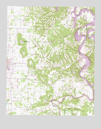
Sonora, AR USGS Topographic Map
Click on map above to begin viewing in our Map Viewer.

This topographic map contains these locations and features:
Feature Name Type Latitude Longitude GNIS ID View Map
AccidentPopulated PlaceN36.2279°W94.1016°75359View Map
Accident SchoolSchoolN36.2281°W94.1010°45776View Map
Bayyari Elementary SchoolSchoolN36.2034°W94.1094°2092979View Map
Beav-O-RamaPopulated PlaceN36.1465°W94.0599°65284View Map
Bland Ferry (historical)CrossingN36.2062°W94.0177°65289View Map
Blue SpringsSpringN36.1595°W94.0027°65291View Map
Blue Springs Use AreaParkN36.1617°W94.0038°65292View Map
Blue Springs VillagePopulated PlaceN36.1751°W94.0155°65293View Map
Bobby Hopper ParkParkN36.1870°W94.1096°65294View Map
Cedar BluffCliffN36.1512°W94.0008°47564View Map
Circle S Farms AirportAirportN36.2283°W94.0323°83759View Map
CreechPopulated PlaceN36.2265°W94.0355°57605View Map
Davis CemeteryCemeteryN36.1528°W94.0082°48385View Map
Dibler CemeteryCemeteryN36.2376°W94.0074°48506View Map
Eastside Youth CenterBuildingN36.1831°W94.1241°65320View Map
Elmdale Shopping CenterLocaleN36.1870°W94.1191°65326View Map
Evergreen SchoolSchoolN36.2026°W94.0094°48951View Map
Fishback SchoolSchoolN36.1704°W94.0949°49069View Map
Fitzgerald MountainSummitN36.1992°W94.1021°76929View Map
Friendship Baptist ChurchChurchN36.1706°W94.0855°76987View Map
Friendship CreekStreamN36.1867°W94.0288°49270View Map
Friendship School (historical)SchoolN36.1709°W94.0858°84306View Map
Gibson Ford (historical)CrossingN36.2156°W94.0069°65360View Map
Goshen Fire Department Station 2BuildingN36.1442°W94.0350°2116487View Map
Harp Elementary SchoolSchoolN36.1601°W94.0958°2039063View Map
Harp MountainSummitN36.1537°W94.0599°65368View Map
Head CemeteryCemeteryN36.1601°W94.0124°49974View Map
Head Ford (historical)CrossingN36.1609°W94.0080°65369View Map
Helton BluffCliffN36.2454°W94.0213°49998View Map
Helton Ford (historical)CrossingN36.2437°W94.0213°75545View Map
Hewitt SpringSpringN36.1722°W94.0851°77169View Map
Hickory CreekStreamN36.2254°W94.0305°77171View Map
Hickory Creek Baptist ChurchChurchN36.2284°W94.0341°75548View Map
Hickory Creek CemeteryCemeteryN36.2290°W94.0341°75549View Map
Hickory Creek SchoolSchoolN36.2284°W94.0338°50051View Map
Hickory Creek Volunteer Fire DepartmentBuildingN36.2444°W94.0383°2116559View Map
J O Kelly Middle SchoolSchoolN36.1641°W94.1113°2039057View Map
Jones Elementary SchoolSchoolN36.1752°W94.1246°65418View Map
KCIZ-FM (Springdale)TowerN36.1801°W94.0855°85429View Map
KFAA-TV (Rogers)TowerN36.2042°W94.1016°85445View Map
KQXK-AM (Springdale)TowerN36.2059°W94.1199°85344View Map
Lake Fayetteville ParkParkN36.1356°W94.1238°65419View Map
Little Hickory CreekStreamN36.2404°W94.0338°51280View Map
Martin BluffCliffN36.2401°W94.0227°51698View Map
Mill HollowValleyN36.1415°W94.0013°52043View Map
Monitor SchoolSchoolN36.2051°W94.0844°52131View Map
Mountain Home SchoolLocaleN36.1329°W94.0202°52494View Map
Neills BluffCliffN36.1431°W94.0591°52602View Map
Neills Bluff Ford (historical)CrossingN36.1395°W94.0602°65392View Map
Nob Hill Fire Department Station 2BuildingN36.1658°W94.0464°2116854View Map
Nob Hill Station 3BuildingN36.2195°W94.0135°2116855View Map
Northwest Arkansas Vocational-Technical SchoolSchoolN36.1781°W94.1158°65398View Map
Parsons Hills Elementary SchoolSchoolN36.1728°W94.1068°65405View Map
Pentecostal Church of GodChurchN36.1867°W94.1230°65406View Map
Phillips CemeteryCemeteryN36.2381°W94.0963°77989View Map
Pleasure HeightsPopulated PlaceN36.2362°W94.0155°58404View Map
Price MountainSummitN36.1684°W94.0741°58430View Map
Roberts CreekStreamN36.1462°W94.0266°54071View Map
Rochelle RivieraPopulated PlaceN36.1542°W94.0180°65427View Map
SonoraPopulated PlaceN36.1654°W94.0449°55002View Map
Sonora Baptist ChurchChurchN36.1659°W94.0446°65448View Map
Southern Grove Baptist ChurchChurchN36.2095°W94.0646°78418View Map
Springdale Fire Department Station 5BuildingN36.1672°W94.1116°2117164View Map
Springdale Municipal AirportAirportN36.1744°W94.1208°83836View Map
Tenenbaum LakeReservoirN36.1673°W94.0528°80130View Map
Tenenbaum Lake DamDamN36.1667°W94.0535°80129View Map
Township of SpringdaleCivilN36.1752°W94.1129°69803View Map
Vista Health FayettevilleBuildingN36.1279°W94.1199°2092905View Map
War Eagle Public Use AreaParkN36.2179°W94.0158°78691View Map
Webber MountainSummitN36.1854°W94.0905°58842View Map
Wilson CemeteryCemeteryN36.2109°W94.0849°56438View Map
Zion ChurchChurchN36.1326°W94.0963°65502View Map
Zion SchoolSchoolN36.1323°W94.0955°56652View Map

Note: Coordinates in the location and feature list above are referenced to NAD83 datum.


Copyright (C) 2008-2024 Ryan Niemi / Sunset Dynamics ... All Rights Reserved