TopoQuest Logo
Do you find TopoQuest useful?
Help keep TopoQuest running and adding new maps/features by donating!
Bitcoin:  19c7KJd3qBynnjoSw5npx9KScwjBe4ifkT
Litecoin:  LXs6TkuXGGXo1vDsWCkWVdjQX94eUKd6ui
Home View Maps Find Maps Find Places Resources & Links


Somerset South, Wisconsin Topographic Map

USGS Map Title: Somerset South, WI
USGS Map MRC: 45092A6
DRG (GeoTIFF) Download: o45092a6.tif


Neighboring USGS Topographic Map Quads:


  Marine on St. Croix, MN  
45092B7
 

  Somerset North, WI  
45092B6
 

  New Richmond North, WI  
45092B5
 

  Stillwater, MN  
45092A7
 

  Somerset South, WI  
45092A6
 

  New Richmond South, WI  
45092A5
 

  Hudson, WI  
44092H7
 

  Northline, WI  
44092H6
 

  Roberts, WI  
44092H5


Map MRC Location:

N46°
W93°
N46°
W92°
H8 H7 H6 H5 H4 H3 H2 H1
G8 G7 G6 G5 G4 G3 G2 G1
F8 F7 F6 F5 F4 F3 F2 F1
E8 E7 E6 E5 E4 E3 E2 E1
D8 D7 D6 D5 D4 D3 D2 D1
C8 C7 C6 C5 C4 C3 C2 C1
B8 B7 B6 B5 B4 B3 B2 B1
A8 A7 A6 A5 A4 A3 A2 A1
N45°
W93°
N45°
W92°

Somerset South, WI USGS 1:24K Topographic Map Preview:
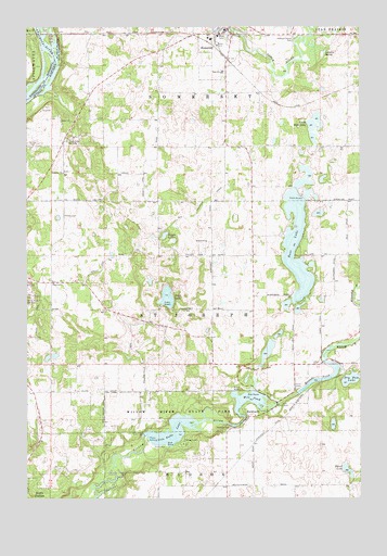
Somerset South, WI USGS Topographic Map
Click on map above to begin viewing in our Map Viewer.

This topographic map contains these locations and features:
Feature Name Type Latitude Longitude GNIS ID View Map
Bass LakeLakeN45.0671°W92.6489°1581589View Map
Beer AirportAirportN45.0346°W92.6556°1582018View Map
Big MoundSummitN45.0603°W92.6260°2746846View Map
Birch Park Ski AreaLocaleN45.0533°W92.7488°1581592View Map
Bright LakeLakeN45.0697°W92.6985°1581599View Map
BurkhardtPopulated PlaceN45.0216°W92.6671°1581602View Map
Burkhardt StationPopulated PlaceN45.0144°W92.6655°1581814View Map
Dry Dam LakeLakeN45.0316°W92.6277°1581621View Map
Elm Park School (historical)SchoolN45.0572°W92.7399°1581816View Map
Emanuel ChurchChurchN45.0866°W92.7363°1581626View Map
Fairview School (historical)SchoolN45.0036°W92.6571°1581817View Map
Floaters Haven ParkParkN45.1219°W92.6485°1581630View Map
Four Corners School (historical)SchoolN45.0641°W92.6808°1581818View Map
Hudson TownhallBuildingN45.0036°W92.6758°1831749View Map
Irlbeck AirportAirportN45.0955°W92.6709°1582213View Map
Landing Hill School (historical)SchoolN45.1008°W92.7263°1581820View Map
Levesque SpringSpringN45.1186°W92.6380°1581665View Map
Little Falls DamDamN45.0169°W92.7063°1791762View Map
Little Falls LakeReservoirN45.0158°W92.6958°1581667View Map
McKinley School (historical)SchoolN45.0283°W92.7313°1581822View Map
Mill Pond (historical)ReservoirN45.0265°W92.6686°1581677View Map
Mound Plant WP 224 DamDamN45.0277°W92.6483°1791714View Map
Mounds Pond (historical)ReservoirN45.0313°W92.6412°1581679View Map
Mount HellenSummitN45.0286°W92.6416°2746847View Map
North Bass LakeLakeN45.0989°W92.6433°1581682View Map
North Bass Lake School (historical)SchoolN45.0930°W92.6666°1581823View Map
Perch LakeLakeN45.0532°W92.6977°1581698View Map
Pioneer CemeteryCemeteryN45.0750°W92.7363°1581701View Map
Saint Joseph TownhallBuildingN45.0569°W92.7402°1831693View Map
Saint Joseph Volunteer Fire and Rescue DepartmentBuildingN45.0567°W92.7397°2696768View Map
Shank LakeLakeN45.0074°W92.6301°1581722View Map
Snow Crest Ski AreaLocaleN45.0950°W92.7344°1581723View Map
SomersetPopulated PlaceN45.1244°W92.6735°1581724View Map
Somerset Elementary SchoolSchoolN45.1132°W92.6840°1831695View Map
Somerset Fire and RescueBuildingN45.1243°W92.6630°2696744View Map
Somerset High SchoolSchoolN45.1118°W92.6792°1831696View Map
Somerset Middle SchoolSchoolN45.1131°W92.6766°2713174View Map
Somerset Police DepartmentBuildingN45.1238°W92.6736°2759588View Map
Somerset Post OfficePost OfficeN45.1246°W92.6597°2768326View Map
Town of Saint JosephCivilN45.0498°W92.7036°1584089View Map
Willow Falls WP 195 DamDamN45.0200°W92.6735°1791710View Map
Willow River State ParkParkN45.0230°W92.6916°1581756View Map

Note: Coordinates in the location and feature list above are referenced to NAD83 datum.


Copyright (C) 2008-2024 Ryan Niemi / Sunset Dynamics ... All Rights Reserved