TopoQuest Logo
Do you find TopoQuest useful?
Help keep TopoQuest running and adding new maps/features by donating!
Bitcoin:  19c7KJd3qBynnjoSw5npx9KScwjBe4ifkT
Litecoin:  LXs6TkuXGGXo1vDsWCkWVdjQX94eUKd6ui
Home View Maps Find Maps Find Places Resources & Links


Black Star Canyon, California Topographic Map

USGS Map Title: Black Star Canyon, CA
USGS Map MRC: 33117G6
DRG (GeoTIFF) Download: o33117g6.tif


Neighboring USGS Topographic Map Quads:


  Yorba Linda, CA  
33117H7
 

  Prado Dam, CA  
33117H6
 

  Corona North, CA  
33117H5
 

  Orange, CA  
33117G7
 

  Black Star Canyon, CA  
33117G6
 

  Corona South, CA  
33117G5
 

  Tustin, CA  
33117F7
 

  El Toro, CA  
33117F6
 

  Santiago Peak, CA  
33117F5


Map MRC Location:

N34°
W118°
N34°
W117°
H8 H7 H6 H5 H4 H3 H2 H1
G8 G7 G6 G5 G4 G3 G2 G1
F8 F7 F6 F5 F4 F3 F2 F1
E8 E7 E6 E5 E4 E3 E2 E1
D8 D7 D6 D5 D4 D3 D2 D1
C8 C7 C6 C5 C4 C3 C2 C1
B8 B7 B6 B5 B4 B3 B2 B1
A8 A7 A6 A5 A4 A3 A2 A1
N33°
W118°
N33°
W117°

Black Star Canyon, CA USGS 1:24K Topographic Map Preview:
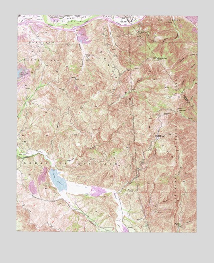
Black Star Canyon, CA USGS Topographic Map
Click on map above to begin viewing in our Map Viewer.

This topographic map contains these locations and features:
Feature Name Type Latitude Longitude GNIS ID View Map
Anaheim Canyon Post OfficePost OfficeN33.8665°W117.7441°2769319View Map
Anaheim Fire Department Station 10BuildingN33.8633°W117.7423°2664839View Map
Anaheim Police DepartmentBuildingN33.8687°W117.7463°2756309View Map
Baker CanyonValleyN33.7617°W117.6762°269634View Map
Bee CanyonValleyN33.8747°W117.7217°239143View Map
Beeks PlacePopulated PlaceN33.8203°W117.6387°269785View Map
Black Star CanyonValleyN33.7734°W117.6823°269900View Map
Black Star Coal MineMineN33.7745°W117.6734°269901View Map
Black Star CreekStreamN33.7731°W117.6823°269902View Map
Blind CanyonValleyN33.7953°W117.7303°269914View Map
Carbondale (historical)Populated PlaceN33.7534°W117.6773°1765942View Map
Childrens Montessori CenterSchoolN33.8698°W117.6261°2455915View Map
Claymont Clay MineMineN33.8525°W117.6839°270491View Map
Coal CanyonValleyN33.8717°W117.6887°270514View Map
Exit 39CrossingN33.8706°W117.7450°2129636View Map
Exit 41CrossingN33.8667°W117.7117°2129637View Map
Exit 42CrossingN33.8719°W117.6869°2129638View Map
Fremont CanyonValleyN33.7906°W117.7251°271221View Map
Gypsum CanyonValleyN33.8667°W117.7123°271462View Map
Gypsum CreekStreamN33.8695°W117.7126°1693429View Map
Hall CanyonValleyN33.7597°W117.6609°271479View Map
Harvill Number 1 798-002 DamDamN33.8633°W117.7476°1664061View Map
Harvill Number 2 798 DamDamN33.8633°W117.7442°1664060View Map
Hidden RanchLocaleN33.8050°W117.6531°271566View Map
Horsetrough SpringSpringN33.8183°W117.6489°271661View Map
Irvine LakeReservoirN33.7850°W117.7242°1663533View Map
Irvine Lake ParkParkN33.7684°W117.7189°277077View Map
Irvine ParkParkN33.7953°W117.7484°271735View Map
KSRT-AM (Orange)TowerN33.8286°W117.6403°1664895View Map
Limestone CanyonValleyN33.7647°W117.7103°272043View Map
Loma RidgeRidgeN33.7509°W117.7206°272167View Map
Lomas de SantiagoCivilN33.7881°W117.7145°272169View Map
Martin Luther King Ambulatory Surgical CenterHospitalN33.8660°W117.7431°2455535View Map
Mustang SpringSpringN33.7549°W117.6373°272611View Map
MWD Santiago LateralCanalN33.8178°W117.7439°272293View Map
Oak FlatFlatN33.8283°W117.6378°272736View Map
Orange County Fire Authority Station 53BuildingN33.8743°W117.7104°2664684View Map
Orange County Sheriffs DepartmentBuildingN33.7651°W117.7460°2756386View Map
Santa Ana Valley CanalCanalN33.8736°W117.7406°273541View Map
Santiago Coal MineMineN33.7820°W117.7037°273576View Map
Santiago Creek 75 DamDamN33.7850°W117.7242°1663532View Map
Santiago DamDamN33.7861°W117.7253°273579View Map
Santiago ReservoirReservoirN33.7746°W117.7093°273581View Map
Sierra PeakSummitN33.8503°W117.6539°273703View Map
Sierra Peak Guard Station (historical)LocaleN33.8236°W117.6384°1693431View Map
Silverado CanyonValleyN33.7564°W117.6776°273712View Map
Silverado CreekStreamN33.7561°W117.6776°273713View Map
Sycamore ParkParkN33.8742°W117.6995°274011View Map
Walnut Canyon ReservoirReservoirN33.8414°W117.7498°274374View Map

Note: Coordinates in the location and feature list above are referenced to NAD83 datum.


Copyright (C) 2008-2024 Ryan Niemi / Sunset Dynamics ... All Rights Reserved