TopoQuest Logo
Do you find TopoQuest useful?
Help keep TopoQuest running and adding new maps/features by donating!
Bitcoin:  19c7KJd3qBynnjoSw5npx9KScwjBe4ifkT
Litecoin:  LXs6TkuXGGXo1vDsWCkWVdjQX94eUKd6ui
Home View Maps Find Maps Find Places Resources & Links


Smithville, West Virginia Topographic Map

USGS Map Title: Smithville, WV
USGS Map MRC: 39081A1
DRG (GeoTIFF) Download: o39081a1.tif


Neighboring USGS Topographic Map Quads:


  Cairo, WV  
39081B2
 

  Harrisville, WV  
39081B1
 

  Pullman, WV  
39080B8
 

  MacFarlan, WV  
39081A2
 

  Smithville, WV  
39081A1
 

  Burnt House, WV  
39080A8
 

  Annamoriah, WV  
38081H2
 

  Grantsville, WV  
38081H1
 

  Tanner, WV  
38080H8


Map MRC Location:

N40°
W82°
N40°
W81°
H8 H7 H6 H5 H4 H3 H2 H1
G8 G7 G6 G5 G4 G3 G2 G1
F8 F7 F6 F5 F4 F3 F2 F1
E8 E7 E6 E5 E4 E3 E2 E1
D8 D7 D6 D5 D4 D3 D2 D1
C8 C7 C6 C5 C4 C3 C2 C1
B8 B7 B6 B5 B4 B3 B2 B1
A8 A7 A6 A5 A4 A3 A2 A1
N39°
W82°
N39°
W81°

Smithville, WV USGS 1:24K Topographic Map Preview:
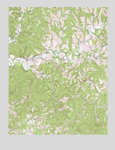
Smithville, WV USGS Topographic Map
Click on map above to begin viewing in our Map Viewer.

This topographic map contains these locations and features:
Feature Name Type Latitude Longitude GNIS ID View Map
Ayers CemeteryCemeteryN39.0720°W81.0921°1535090View Map
Barcus Ayers FordCrossingN39.0931°W81.1179°1688921View Map
Bean RidgeRidgeN39.0554°W81.0443°1535336View Map
Bell School (historical)SchoolN39.0284°W81.0151°1688925View Map
Bethany ChurchChurchN39.0954°W81.0209°1535680View Map
Betheny ChurchyardCemeteryN39.0965°W81.0215°1688926View Map
Broadtree RunStreamN39.0301°W81.0771°1536376View Map
Buzzard CemeteryCemeteryN39.0854°W81.0021°1536811View Map
Cain RunStreamN39.1051°W81.0068°1536851View Map
Camden FlatsFlatN39.0115°W81.0790°1536877View Map
Campbell HillSummitN39.0226°W81.0946°1554056View Map
Cedar Grove ChurchChurchN39.1004°W81.1107°1537133View Map
Cedar Grove School (historical)SchoolN39.1009°W81.1107°1688940View Map
Cedar RunStreamN39.0748°W81.1104°1537141View Map
Cloverleaf CemeteryCemeteryN39.0023°W81.1121°1537431View Map
Crab RunStreamN39.0556°W81.1248°1537767View Map
Cunningham CemeteryCemeteryN39.0856°W81.0759°1537908View Map
Deep Valley School (historical)SchoolN39.0023°W81.0543°1538112View Map
Dry RunStreamN39.0984°W81.1123°1538374View Map
Dry RunStreamN39.0759°W81.0129°1538386View Map
EvaPopulated PlaceN39.0331°W81.0282°1549676View Map
Fluharty CemeteryCemeteryN39.0148°W81.0982°1696858View Map
FonzoPopulated PlaceN39.0731°W81.0515°1549688View Map
Fonzo Post Office (historical)Post OfficeN39.0734°W81.0512°1688967View Map
Fox CemeteryCemeteryN39.0273°W81.0929°1539203View Map
Fox RunStreamN39.0245°W81.0843°1539207View Map
Frederick CemeteryCemeteryN39.0767°W81.0559°1539240View Map
GoffsPopulated PlaceN39.0901°W81.0346°1549709View Map
Goffs Post Office (historical)Post OfficeN39.0912°W81.0332°1688969View Map
Grass RunStreamN39.0742°W81.0559°1539611View Map
Grass Run School (historical)SchoolN39.0501°W81.0151°1688972View Map
Hardman Chapel CemeteryCemeteryN39.0580°W81.0518°2586185View Map
Hardman ChurchChurchN39.0576°W81.0515°1539945View Map
Hatfield CemeteryCemeteryN39.0854°W81.0301°1540059View Map
Haught CemeteryCemeteryN39.0934°W81.1204°1540068View Map
Heavener ForkStreamN39.0309°W81.0637°1540111View Map
Henry RunStreamN39.1042°W81.1115°1540161View Map
Iris (historical)Populated PlaceN39.0337°W81.0551°1688988View Map
Jesse Cain RunStreamN39.1034°W81.0151°1540884View Map
King Knob CemeteryCemeteryN39.1245°W81.0637°1541209View Map
Lamb RunStreamN39.0804°W81.0629°1541322View Map
Leatherbark CreekStreamN39.0642°W81.1018°1541586View Map
Leatherbark School (historical)SchoolN39.0281°W81.0582°1688998View Map
Lick RunStreamN39.0490°W81.0168°1541919View Map
Lick RunStreamN39.0904°W81.0359°1541922View Map
Little Indian RunStreamN39.1187°W81.1082°1542129View Map
Long RunPopulated PlaceN39.1045°W81.0359°1689003View Map
Long RunStreamN39.0904°W81.0309°1542416View Map
Lynncamp RunStreamN39.0273°W81.0154°1542651View Map
Maberry RunStreamN39.0951°W81.1248°1542661View Map
MahonePopulated PlaceN39.1092°W81.0746°1549804View Map
Mahone Post OfficePost OfficeN39.1092°W81.0748°1689010View Map
Middle Fork Leatherbark CreekStreamN39.0517°W81.0671°1543186View Map
Murphy DistrictCivilN39.0814°W81.0950°1928318View Map
Oak Grove School (historical)SchoolN39.0520°W81.0365°1689022View Map
Owl RunStreamN39.0831°W81.0726°1544496View Map
Plum RunStreamN39.1048°W81.1109°1545064View Map
Prosperity ChurchChurchN39.0065°W81.0976°1545291View Map
Prosperity School (historical)SchoolN39.0062°W81.0971°1696910View Map
PruntyPopulated PlaceN39.1073°W81.0054°1549884View Map
Prunty RunStreamN39.0456°W81.0696°1545305View Map
Reeves CemeteryCemeteryN39.0884°W81.0246°1545498View Map
Ritchie County Ambulance Authority Station 43BuildingN39.0748°W81.0840°2581063View Map
Road ForkStreamN39.0612°W81.0918°1545814View Map
Rock RunStreamN39.0726°W81.0201°1552702View Map
Rocklick RunStreamN39.0329°W81.0287°1545994View Map
Rocky RunStreamN39.1170°W81.1093°1546032View Map
Saunders CemeteryCemeteryN39.0029°W81.0959°1696921View Map
Seths ForkStreamN39.0037°W81.1184°1546582View Map
Smith RunStreamN39.1112°W81.0012°1547002View Map
SmithvillePopulated PlaceN39.0740°W81.0943°1547009View Map
Smithville Baptist ChurchChurchN39.0745°W81.0934°1689059View Map
Smithville Elementary SchoolSchoolN39.0741°W81.0918°1689060View Map
Smithville Post OfficePost OfficeN39.0752°W81.0957°1689061View Map
Smithville Volunteer Fire DepartmentBuildingN39.0748°W81.0839°2578032View Map
Spruce CreekStreamN39.0795°W81.0362°1547227View Map
ThursdayLocaleN39.0520°W81.0223°1548082View Map
Wass RunStreamN39.0995°W81.0315°1548829View Map
Wass School (historical)SchoolN39.1192°W81.0201°1689086View Map
Westfall CemeteryCemeteryN39.0767°W81.0937°1548963View Map
Wigner RunStreamN39.0809°W81.0773°1549126View Map
Wolf RunStreamN39.0515°W81.0221°1549288View Map

Note: Coordinates in the location and feature list above are referenced to NAD83 datum.


Copyright (C) 2008-2024 Ryan Niemi / Sunset Dynamics ... All Rights Reserved