TopoQuest Logo
Do you find TopoQuest useful?
Help keep TopoQuest running and adding new maps/features by donating!
Bitcoin:  19c7KJd3qBynnjoSw5npx9KScwjBe4ifkT
Litecoin:  LXs6TkuXGGXo1vDsWCkWVdjQX94eUKd6ui
Home View Maps Find Maps Find Places Resources & Links


Smithville, Michigan Topographic Map

USGS Map Title: Smithville, MI
USGS Map MRC: 44085E2
DRG (GeoTIFF) Download: o44085e2.tif


Neighboring USGS Topographic Map Quads:


  South Boardman, MI  
44085F3
 

  Kalkaska, MI  
44085F2
 

  Sigma, MI  
44085F1
 

  Fife Lake, MI  
44085E3
 

  Smithville, MI  
44085E2
 

  Sharon, MI  
44085E1


Map MRC Location:

N45°
W86°
N45°
W85°
H8 H7 H6 H5 H4 H3 H2 H1
G8 G7 G6 G5 G4 G3 G2 G1
F8 F7 F6 F5 F4 F3 F2 F1
E8 E7 E6 E5 E4 E3 E2 E1
D8 D7 D6 D5 D4 D3 D2 D1
C8 C7 C6 C5 C4 C3 C2 C1
B8 B7 B6 B5 B4 B3 B2 B1
A8 A7 A6 A5 A4 A3 A2 A1
N44°
W86°
N44°
W85°

Smithville, MI USGS 1:24K Topographic Map Preview:
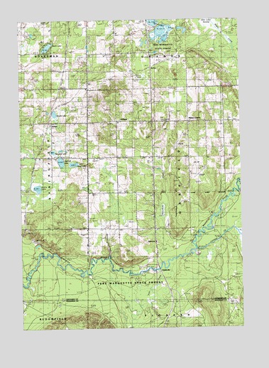
Smithville, MI USGS Topographic Map
Click on map above to begin viewing in our Map Viewer.

This topographic map contains these locations and features:
Feature Name Type Latitude Longitude GNIS ID View Map
Breeds LakeLakeN44.5875°W85.2309°621914View Map
Comfort Post Office (historical)Post OfficeN44.5764°W85.2083°2463630View Map
DeibertPopulated PlaceN44.5839°W85.2326°1617520View Map
Deibert CemeteryCemeteryN44.5839°W85.2417°2494762View Map
Filer CreekStreamN44.5242°W85.1728°625946View Map
Garfield CemeteryCemeteryN44.5842°W85.1698°626654View Map
Garfield Country ChurchChurchN44.5842°W85.1447°2494770View Map
Garfield Lookout TowerTowerN44.5953°W85.1987°1623361View Map
Garfield Township Fire DepartmentBuildingN44.5840°W85.1681°2494768View Map
Garfield Township HallBuildingN44.5842°W85.1683°2494769View Map
GiddingsPopulated PlaceN44.5845°W85.1962°1617582View Map
Ingersoll LakeLakeN44.5677°W85.2270°629033View Map
Ivan Post Office (historical)Post OfficeN44.5833°W85.1544°2494711View Map
Jones LakeLakeN44.5666°W85.2199°629375View Map
Kaska Post Office (historical)Post OfficeN44.5694°W85.1750°2494709View Map
Little Cannon CreekStreamN44.5322°W85.1514°630584View Map
McGeePopulated PlaceN44.6056°W85.1750°2104180View Map
Millers CornersPopulated PlaceN44.5842°W85.1542°2104179View Map
Nelson CreekStreamN44.5300°W85.2009°633276View Map
Perch LakeLakeN44.6141°W85.2340°634632View Map
Perrin SchoolSchoolN44.5836°W85.1350°634662View Map
Sickle LakeLakeN44.5569°W85.2403°637872View Map
SmithvillePopulated PlaceN44.5242°W85.1742°638179View Map
Smithville Forest CampgroundLocaleN44.5242°W85.1825°2494736View Map
TaffeltownPopulated PlaceN44.5406°W85.1750°1617888View Map
Twentyeight LakesLakeN44.6196°W85.1686°1615223View Map
Twentyone HillSummitN44.5528°W85.1620°1615226View Map
Waterhole CreekStreamN44.5311°W85.1700°1615848View Map
Woodard LakeLakeN44.5716°W85.2315°1616733View Map

Note: Coordinates in the location and feature list above are referenced to NAD83 datum.


Copyright (C) 2008-2024 Ryan Niemi / Sunset Dynamics ... All Rights Reserved