TopoQuest Logo
Do you find TopoQuest useful?
Help keep TopoQuest running and adding new maps/features by donating!
Bitcoin:  19c7KJd3qBynnjoSw5npx9KScwjBe4ifkT
Litecoin:  LXs6TkuXGGXo1vDsWCkWVdjQX94eUKd6ui
Home View Maps Find Maps Find Places Resources & Links


Smithson Valley, Texas Topographic Map

USGS Map Title: Smithson Valley, TX
USGS Map MRC: 29098G3
DRG (GeoTIFF) Download: o29098g3.tif


Neighboring USGS Topographic Map Quads:


  Spring Branch, TX  
29098H4
 

  Fischer, TX  
29098H3
 

  Devils Backbone, TX  
29098H2
 

  Anhalt, TX  
29098G4
 

  Smithson Valley, TX  
29098G3
 

  Sattler, TX  
29098G2
 

  Bulverde, TX  
29098F4
 

  Bat Cave, TX  
29098F3
 

  New Braunfels West, TX  
29098F2


Map MRC Location:

N30°
W99°
N30°
W98°
H8 H7 H6 H5 H4 H3 H2 H1
G8 G7 G6 G5 G4 G3 G2 G1
F8 F7 F6 F5 F4 F3 F2 F1
E8 E7 E6 E5 E4 E3 E2 E1
D8 D7 D6 D5 D4 D3 D2 D1
C8 C7 C6 C5 C4 C3 C2 C1
B8 B7 B6 B5 B4 B3 B2 B1
A8 A7 A6 A5 A4 A3 A2 A1
N29°
W99°
N29°
W98°

Smithson Valley, TX USGS 1:24K Topographic Map Preview:
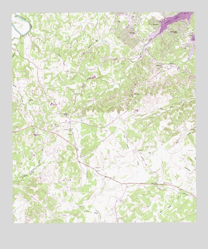
Smithson Valley, TX USGS Topographic Map
Click on map above to begin viewing in our Map Viewer.

This topographic map contains these locations and features:
Feature Name Type Latitude Longitude GNIS ID View Map
Allen ParkParkN29.8266°W98.2920°1351002View Map
Bear Creek Ranch AirportAirportN29.8098°W98.2715°2675847View Map
Canyon Lake DivisionCivilN29.8525°W98.3428°1938639View Map
Canyon Lake Fire / Emergency Medical Service Station 2BuildingN29.8671°W98.2890°2552656View Map
Canyon Lake ForestPopulated PlaceN29.8619°W98.2631°1353776View Map
Canyon SpringsPopulated PlaceN29.8727°W98.2875°1372940View Map
Comal CountyCivilN29.8082°W98.2782°1383831View Map
Cranes Mill CemeteryCemeteryN29.8633°W98.2906°1355312View Map
Grace Bible Fellowship ChurchChurchN29.8738°W98.2983°2017528View Map
Heimer CemeteryCemeteryN29.7930°W98.2900°1359000View Map
Jonas CemeteryCemeteryN29.8584°W98.3164°1360370View Map
Kraft CemeteryCemeteryN29.7913°W98.2806°1360762View Map
Krause LakeReservoirN29.8367°W98.3201°1863679View Map
Krause Lake DamDamN29.8369°W98.3186°1863678View Map
Miller CreekStreamN29.8619°W98.3692°1362896View Map
Rust CemeteryCemeteryN29.8730°W98.3733°1367044View Map
Sherwood SchoolSchoolN29.8455°W98.3625°1368137View Map
Simon CemeteryCemeteryN29.8697°W98.3003°1368303View Map
Smithson ValleyPopulated PlaceN29.8130°W98.3372°1380562View Map
Smithson Valley CemeteryCemeteryN29.8052°W98.3345°1368514View Map
Smithson Valley High SchoolSchoolN29.8047°W98.3511°2004835View Map
Startz HillSummitN29.8227°W98.2922°1369130View Map
StartzvillePopulated PlaceN29.8447°W98.2739°1369131View Map
Tom CreekStreamN29.8652°W98.2720°1369994View Map
Valley ViewPopulated PlaceN29.7727°W98.2756°1380706View Map
Weidner CemeteryCemeteryN29.8230°W98.3636°1370994View Map
WesthavenPopulated PlaceN29.8658°W98.2778°1371294View Map

Note: Coordinates in the location and feature list above are referenced to NAD83 datum.


Copyright (C) 2008-2024 Ryan Niemi / Sunset Dynamics ... All Rights Reserved