TopoQuest Logo
Do you find TopoQuest useful?
Help keep TopoQuest running and adding new maps/features by donating!
Bitcoin:  19c7KJd3qBynnjoSw5npx9KScwjBe4ifkT
Litecoin:  LXs6TkuXGGXo1vDsWCkWVdjQX94eUKd6ui
Home View Maps Find Maps Find Places Resources & Links


Smiths Station, Alabama Topographic Map

USGS Map Title: Smiths Station, AL
USGS Map MRC: 32085E1
DRG (GeoTIFF) Download: o32085e1.tif


Neighboring USGS Topographic Map Quads:


  Beulah, AL  
32085F2
 

  Bartletts Ferry Dam, GA  
32085F1
 

  Mulberry Grove, GA  
32084F8
 

  Bleecker, AL  
32085E2
 

  Smiths Station, AL  
32085E1
 

  Fortson, GA  
32084E8
 

  Crawford, AL  
32085D2
 

  Phenix City, AL  
32085D1
 

  Columbus, GA  
32084D8


Map MRC Location:

N33°
W86°
N33°
W85°
H8 H7 H6 H5 H4 H3 H2 H1
G8 G7 G6 G5 G4 G3 G2 G1
F8 F7 F6 F5 F4 F3 F2 F1
E8 E7 E6 E5 E4 E3 E2 E1
D8 D7 D6 D5 D4 D3 D2 D1
C8 C7 C6 C5 C4 C3 C2 C1
B8 B7 B6 B5 B4 B3 B2 B1
A8 A7 A6 A5 A4 A3 A2 A1
N32°
W86°
N32°
W85°

Smiths Station, AL USGS 1:24K Topographic Map Preview:
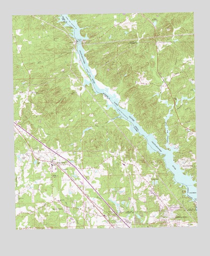
Smiths Station, AL USGS Topographic Map
Click on map above to begin viewing in our Map Viewer.

This topographic map contains these locations and features:
Feature Name Type Latitude Longitude GNIS ID View Map
Bethany Baptist ChurchChurchN32.5190°W85.0288°154441View Map
Bethel MissionChurchN32.5796°W85.1202°114091View Map
Bethel Mission CemeteryCemeteryN32.5796°W85.1127°114092View Map
Biggers LakeReservoirN32.5728°W85.0124°311426View Map
Blackmon DamDamN32.5735°W85.0099°340429View Map
Blackmon LakeReservoirN32.5748°W85.0063°340430View Map
Byrd Island (historical)IslandN32.5457°W85.0255°357274View Map
C L Mullins DamDamN32.5301°W85.0833°130663View Map
Carriage HillPopulated PlaceN32.5021°W85.0241°138708View Map
City of Smiths StationCivilN32.5344°W85.1091°2405476View Map
Clyde Powell DamDamN32.5401°W85.1216°130672View Map
Columbus Fire and Emergency Medical Services Station 14BuildingN32.5821°W85.0195°2604896View Map
Community ChurchChurchN32.5179°W85.1230°163467View Map
Cornerstone ChurchChurchN32.5671°W85.1194°163469View Map
Douglas CreekStreamN32.5837°W85.0222°357324View Map
Friendship Firefighters Association Station 2BuildingN32.5118°W85.0828°2691112View Map
Fullers LakesReservoirN32.5410°W85.1209°118751View Map
Glenwood SchoolSchoolN32.5371°W85.0499°138177View Map
Glovers ChurchChurchN32.5074°W85.0555°119061View Map
Goat Rock DamDamN32.6101°W85.0783°337189View Map
Goat Rock DamDamN32.6093°W85.0802°119073View Map
Goat Rock DamDamN32.6093°W85.0785°314662View Map
Goat Rock Recreation AreaParkN32.6071°W85.0833°138178View Map
Green Island HillsPopulated PlaceN32.5351°W85.0072°331863View Map
Green Island Hills Golf CourseLocaleN32.5376°W85.0083°357366View Map
H H Webb DamDamN32.5135°W85.0549°130647View Map
Heiferhorn CreekStreamN32.5710°W85.0155°315300View Map
Jack Hughston Memorial HospitalHospitalN32.5083°W85.0088°2669287View Map
Jesus Christ ChurchChurchN32.5013°W85.1033°138202View Map
Jones Light Aviation Airport (historical)AirportN32.5185°W85.0788°2676329View Map
Jordan Company DamDamN32.5768°W85.0249°340427View Map
Jordan Company LakeReservoirN32.5776°W85.0270°340428View Map
Lake ClarmarReservoirN32.5307°W85.0837°130662View Map
Lake ManderlyReservoirN32.6190°W85.0268°317653View Map
Lake Manderly DamDamN32.6187°W85.0269°340489View Map
Lake ThelReservoirN32.5394°W85.1106°127850View Map
Lake Thel DamDamN32.5385°W85.1116°130668View Map
Lake View Memory GardensCemeteryN32.5049°W85.0485°121327View Map
Lakeview Golf CourseLocaleN32.5057°W85.0310°133273View Map
Lakeview ParkParkN32.5026°W85.0358°133274View Map
Lee County International RacewayLocaleN32.5276°W85.1091°163477View Map
Monterey HeightsPopulated PlaceN32.5121°W85.0908°122963View Map
Mount Olive Missionary ChurchChurchN32.5304°W85.0988°154476View Map
Mount Zion CemeteryCemeteryN32.5440°W85.1141°123423View Map
Mount Zion ChurchChurchN32.5346°W85.0908°123466View Map
Mount Zion ChurchChurchN32.5446°W85.1083°123467View Map
Mullins LakeDamN32.5635°W85.0866°130697View Map
New Nelius ChurchChurchN32.5182°W85.1230°163479View Map
Oliver DamDamN32.5154°W85.0010°320055View Map
Phenix City Fire Department Station 4BuildingN32.5000°W85.0130°2691446View Map
Philadelphia Baptist ChurchChurchN32.5163°W85.0949°152880View Map
Philadelphia CemeteryCemeteryN32.5160°W85.0944°138258View Map
Phillips IslandIslandN32.5910°W85.0724°320465View Map
Powell LakeReservoirN32.5410°W85.1209°130671View Map
Price Road Baptist ChurchChurchN32.5018°W85.0516°133314View Map
Rock CreekStreamN32.5640°W85.0502°125751View Map
Rock Creek CoveBayN32.5640°W85.0549°125762View Map
Saint Stephens ChurchChurchN32.5415°W85.0908°163482View Map
Shingle Town (historical)LocaleN32.5021°W85.0944°138303View Map
Smith Station School (historical)SchoolN32.5429°W85.1152°154418View Map
Smiths DamDamN32.5585°W85.0716°130692View Map
Smiths LakeReservoirN32.5576°W85.0749°130691View Map
Smiths StationPopulated PlaceN32.5401°W85.0985°127045View Map
Smiths Station High SchoolSchoolN32.5376°W85.0991°138304View Map
Smiths Station Post OfficePost OfficeN32.5368°W85.0956°2789000View Map
Smiths Station Post Office (historical)Post OfficeN32.5401°W85.0985°167694View Map
Soap CreekStreamN32.5979°W85.0780°127085View Map
Standing Boy CreekStreamN32.5440°W85.0172°356554View Map
Summerville (historical)LocaleN32.5126°W85.0674°138313View Map
Summerville Assembly of God ChurchChurchN32.5382°W85.0477°138314View Map
Turkey CreekStreamN32.5851°W85.0713°128142View Map
Twin LakesReservoirN32.5793°W85.0001°324449View Map
Union Grove United Methodist ChurchChurchN32.6101°W85.0960°153776View Map
Waller LakeReservoirN32.6087°W85.0123°340492View Map
Waller Lake DamDamN32.6085°W85.0133°340491View Map
Walts LandingLocaleN32.5715°W85.0602°138332View Map
Webbs PondReservoirN32.5147°W85.0563°130646View Map
Wrights LakesReservoirN32.5249°W85.0277°129252View Map

Note: Coordinates in the location and feature list above are referenced to NAD83 datum.


Copyright (C) 2008-2024 Ryan Niemi / Sunset Dynamics ... All Rights Reserved