TopoQuest Logo
Do you find TopoQuest useful?
Help keep TopoQuest running and adding new maps/features by donating!
Bitcoin:  19c7KJd3qBynnjoSw5npx9KScwjBe4ifkT
Litecoin:  LXs6TkuXGGXo1vDsWCkWVdjQX94eUKd6ui
Home View Maps Find Maps Find Places Resources & Links


Simmesport, Louisiana Topographic Map

USGS Map Title: Simmesport, LA
USGS Map MRC: 30091H7
DRG (GeoTIFF) Download: o30091h7.tif


Neighboring USGS Topographic Map Quads:


  Moreauville, LA  
31091A8
 

  Big Bend, LA  
31091A7
 

  Turnbull Island, LA  
31091A6
 

  Plaucheville, LA  
30091H8
 

  Simmesport, LA  
30091H7
 

  Innis, LA  
30091H6
 

  Bayou Jack, LA  
30091G8
 

  Bayou Current, LA  
30091G7
 

  Batchelor, LA  
30091G6


Map MRC Location:

N31°
W92°
N31°
W91°
H8 H7 H6 H5 H4 H3 H2 H1
G8 G7 G6 G5 G4 G3 G2 G1
F8 F7 F6 F5 F4 F3 F2 F1
E8 E7 E6 E5 E4 E3 E2 E1
D8 D7 D6 D5 D4 D3 D2 D1
C8 C7 C6 C5 C4 C3 C2 C1
B8 B7 B6 B5 B4 B3 B2 B1
A8 A7 A6 A5 A4 A3 A2 A1
N30°
W92°
N30°
W91°

Simmesport, LA USGS 1:24K Topographic Map Preview:
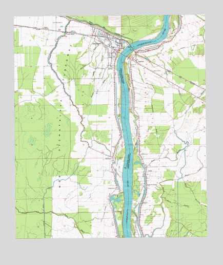
Simmesport, LA USGS Topographic Map
Click on map above to begin viewing in our Map Viewer.

This topographic map contains these locations and features:
Feature Name Type Latitude Longitude GNIS ID View Map
Atchafalaya Flying Company Airport (historical)AirportN30.9444°W91.7937°2676753View Map
Bayou à FerdinandStreamN30.9096°W91.8401°556529View Map
Bayou CasonStreamN30.8899°W91.8562°532488View Map
Bayou CoteauStreamN30.9474°W91.7610°553442View Map
Bayou CreuxStreamN30.9246°W91.8579°540680View Map
Bayou des GlaisesStreamN30.9846°W91.7973°553403View Map
Bayou du CorailStreamN30.9002°W91.8565°540681View Map
Bayou MoreauStreamN30.9163°W91.7898°553495View Map
Bayou ThorntonStreamN30.9085°W91.7660°553531View Map
Beauregard SloughStreamN30.9394°W91.8710°540682View Map
Brushy BayouStreamN30.9305°W91.8235°533456View Map
CasonPopulated PlaceN30.8835°W91.8112°549399View Map
Deer Range LandingLocaleN30.9480°W91.8057°549400View Map
Deer Range PlantationLocaleN30.9232°W91.8201°549401View Map
Dunbar High SchoolSchoolN30.9716°W91.8107°534651View Map
Eden (historical)Populated PlaceN30.9807°W91.7668°546216View Map
Glynville (historical)Populated PlaceN30.9785°W91.7785°546223View Map
Greater Zion Travel ChurchChurchN30.9046°W91.7885°554608View Map
Harlands BayouStreamN30.9502°W91.8246°535527View Map
Horse BayouStreamN30.8980°W91.7787°535797View Map
JacobyPopulated PlaceN30.9152°W91.7893°535992View Map
Jacoby CemeteryCemeteryN30.9107°W91.7896°546229View Map
Jacoby ChapelChurchN30.9107°W91.7898°546230View Map
Jacoby ChurchChurchN30.8949°W91.7910°535993View Map
Jacoby LandingLocaleN30.8919°W91.7996°546231View Map
Kuhlmann BayouStreamN30.9241°W91.7773°536232View Map
La Baie à CasonStreamN30.8835°W91.8357°556531View Map
LegonierPopulated PlaceN30.9735°W91.7940°543390View Map
Lower Deer Range LandingLocaleN30.9202°W91.8037°549404View Map
Marine BayouStreamN30.8760°W91.7912°536896View Map
McCrea School (historical)SchoolN30.8757°W91.7901°546239View Map
Mount Calvary CemeteryCemeteryN30.9966°W91.8482°549405View Map
Mount Calvary ChurchChurchN30.9969°W91.8476°537299View Map
OdenburgPopulated PlaceN30.9205°W91.8107°543552View Map
Parish Governing Authority District 9CivilN30.9354°W91.8645°1930262View Map
Pilgrim Rest Baptist ChurchChurchN30.9763°W91.8140°2745665View Map
Pilgrim Rest Baptist Church CemeteryCemeteryN30.9767°W91.8140°2745666View Map
Pleasant Greens ChurchChurchN30.9032°W91.8079°538239View Map
Riverside Elementary SchoolSchoolN30.9853°W91.8053°545569View Map
Saint John CemeteryCemeteryN30.9718°W91.7979°546268View Map
Saint John ChurchChurchN30.9724°W91.7979°538878View Map
Saint Matthew ChurchChurchN30.9799°W91.7926°538995View Map
Saint Pauls CemeteryCemeteryN30.9221°W91.7926°539033View Map
SimmesportPopulated PlaceN30.9835°W91.8001°539381View Map
Simmesport Police DepartmentBuildingN30.9862°W91.8102°2755276View Map
Simmesport Post OfficePost OfficeN30.9861°W91.8098°1630231View Map
Simmesport Volunteer Fire DepartmentBuildingN30.9856°W91.8114°2672888View Map
State of LouisianaCivilN30.9091°W91.8142°1629543View Map
Sunrise ChurchChurchN30.9271°W91.8096°539736View Map
Town of SimmesportCivilN30.9806°W91.8143°2407344View Map
Tree of Life ChurchChurchN30.9688°W91.7835°539979View Map
Turners Bayou CanalCanalN30.8877°W91.8560°1628394View Map
Ward SevenCivilN30.9696°W91.8190°544916View Map
WaysideLocaleN30.9935°W91.8604°540274View Map
Williams LandingLocaleN30.9046°W91.7987°546280View Map
Wilson BayouStreamN30.9502°W91.8248°540477View Map
Yellow BayouPopulated PlaceN30.9913°W91.8407°543799View Map
Yellow BayouStreamN30.9971°W91.8385°540565View Map

Note: Coordinates in the location and feature list above are referenced to NAD83 datum.


Copyright (C) 2008-2024 Ryan Niemi / Sunset Dynamics ... All Rights Reserved