TopoQuest Logo
Do you find TopoQuest useful?
Help keep TopoQuest running and adding new maps/features by donating!
Bitcoin:  19c7KJd3qBynnjoSw5npx9KScwjBe4ifkT
Litecoin:  LXs6TkuXGGXo1vDsWCkWVdjQX94eUKd6ui
Home View Maps Find Maps Find Places Resources & Links


Sidney, New York Topographic Map

USGS Map Title: Sidney, NY
USGS Map MRC: 42075C4
DRG (GeoTIFF) Download: o42075c4.tif


Neighboring USGS Topographic Map Quads:


  Oxford, NY  
42075D5
 

  Guilford, NY  
42075D4
 

  Gilbertsville, NY  
42075D3
 

  West Bainbridge, NY  
42075C5
 

  Sidney, NY  
42075C4
 

  Unadilla, NY  
42075C3
 

  Afton, NY  
42075B5
 

  North Sanford, NY  
42075B4
 

  Trout Creek, NY  
42075B3


Map MRC Location:

N43°
W76°
N43°
W75°
H8 H7 H6 H5 H4 H3 H2 H1
G8 G7 G6 G5 G4 G3 G2 G1
F8 F7 F6 F5 F4 F3 F2 F1
E8 E7 E6 E5 E4 E3 E2 E1
D8 D7 D6 D5 D4 D3 D2 D1
C8 C7 C6 C5 C4 C3 C2 C1
B8 B7 B6 B5 B4 B3 B2 B1
A8 A7 A6 A5 A4 A3 A2 A1
N42°
W76°
N42°
W75°

Sidney, NY USGS 1:24K Topographic Map Preview:
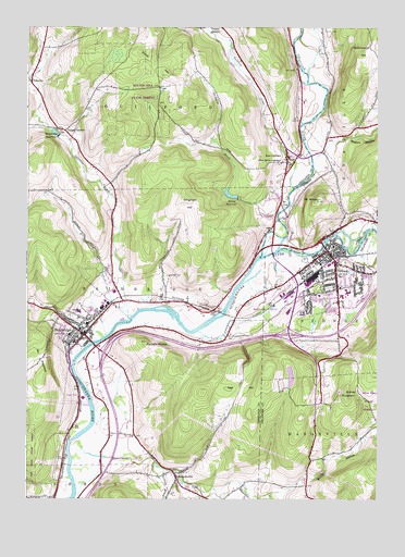
Sidney, NY USGS Topographic Map
Click on map above to begin viewing in our Map Viewer.

This topographic map contains these locations and features:
Feature Name Type Latitude Longitude GNIS ID View Map
BainbridgePopulated PlaceN42.2934°W75.4793°942805View Map
Bainbridge - Guilford High SchoolSchoolN42.2940°W75.4846°2669200View Map
Bainbridge Business ParkLocaleN42.2999°W75.4704°2667550View Map
Bainbridge Fire DepartmentBuildingN42.2939°W75.4805°2734710View Map
Bainbridge Free LibraryBuildingN42.2938°W75.4787°2617213View Map
Bainbridge Methodist ChurchChurchN42.2940°W75.4783°2615557View Map
Bainbridge Post OfficePost OfficeN42.2927°W75.4775°2617802View Map
Bainbridge ReservoirReservoirN42.3468°W75.4897°942806View Map
BennettsvillePopulated PlaceN42.2556°W75.4466°943688View Map
Bennettsville CemeteryCemeteryN42.2566°W75.4499°2496815View Map
Bennettsville CreekStreamN42.2654°W75.4824°943689View Map
Bundy HollowValleyN42.2510°W75.4120°945179View Map
Camels HumpSummitN42.2909°W75.4574°945522View Map
Circle Drive Alliance Church of SidneyChurchN42.3080°W75.3785°2615782View Map
Cooper CemeteryCemeteryN42.3479°W75.4891°2559179View Map
Cooper CornersLocaleN42.3476°W75.4866°947387View Map
Curtis CemeteryCemeteryN42.3739°W75.3937°947951View Map
Dingman HillSummitN42.3298°W75.4443°948464View Map
East GuilfordPopulated PlaceN42.3409°W75.4068°949091View Map
East Guilford CemeteryCemeteryN42.3408°W75.4056°2559180View Map
Faith Community ChurchChurchN42.3101°W75.3897°2615911View Map
First Baptist ChurchChurchN42.3150°W75.3944°2496797View Map
First Baptist ChurchChurchN42.2931°W75.4803°2496809View Map
First Congregational ChurchChurchN42.3164°W75.3931°2496798View Map
Grace Christian FellowshipChurchN42.3026°W75.4519°2616114View Map
Greenlawn CemeteryCemeteryN42.2987°W75.4846°951753View Map
Greenlawn Elementary SchoolSchoolN42.2995°W75.4813°2668853View Map
Guilford CreekStreamN42.3326°W75.4052°951907View Map
Heller's FarmLocaleN42.2797°W75.4772°2560306View Map
Hutchinson HillSummitN42.3637°W75.3824°953544View Map
Kingdom Hall of Jehovahs WitnessesChurchN42.3120°W75.3967°2616581View Map
Main Street BridgeBridgeN42.3175°W75.3942°2614948View Map
Masonville CreekStreamN42.2529°W75.4335°956647View Map
Mount MosesSummitN42.3290°W75.3960°957732View Map
Mount PleasantSummitN42.2873°W75.4952°960742View Map
Mud Pond CreekStreamN42.3481°W75.4927°958109View Map
Neff HillSummitN42.2790°W75.4282°958330View Map
Newton BrookStreamN42.2929°W75.4724°958523View Map
Osborn BrookStreamN42.2581°W75.4510°959498View Map
Parker HollowValleyN42.2501°W75.4105°970455View Map
Pearsall CemeteryCemeteryN42.3095°W75.4495°960057View Map
Peckham BrookStreamN42.3329°W75.4049°960085View Map
Pioneer CemeteryCemeteryN42.3163°W75.3936°2496808View Map
Prospect Hill CemeteryCemeteryN42.3125°W75.3860°2496807View Map
Rogers HollowValleyN42.3431°W75.3916°962818View Map
Sacred Heart ChurchChurchN42.3161°W75.3912°2616861View Map
Saint John's Catholic ChurchChurchN42.2919°W75.4817°2496811View Map
Saint Lukes Evangelical Lutheran Church of SidneyChurchN42.3001°W75.3879°2616957View Map
Saint Paul Episcopal ChurchChurchN42.3144°W75.3947°2496800View Map
Saint Peters Churchyard CemeteryCemeteryN42.2922°W75.4797°2496816View Map
Saint Peters Episcopal ChurchChurchN42.2925°W75.4789°2496812View Map
SidneyPopulated PlaceN42.3148°W75.3916°965212View Map
Sidney Church of ChristChurchN42.3149°W75.3880°2616263View Map
Sidney Elementary SchoolSchoolN42.3047°W75.3847°2496802View Map
Sidney Golf And Country ClubLocaleN42.2964°W75.3911°2496801View Map
Sidney High SchoolSchoolN42.3039°W75.3872°2496804View Map
Sidney Memorial Public LibraryBuildingN42.3159°W75.3933°2617426View Map
Sidney Middle SchoolSchoolN42.3053°W75.3853°2496803View Map
Sidney MountainSummitN42.2773°W75.3860°965215View Map
Sidney Municipal AirportAirportN42.3038°W75.4157°978300View Map
Sidney Post OfficePost OfficeN42.2981°W75.4088°2618124View Map
Sidney ReservoirReservoirN42.3307°W75.4274°965216View Map
Sidney United Methodist ChurchChurchN42.3156°W75.3906°2496799View Map
Sidney Volunteer Fire DepartmentBuildingN42.3124°W75.3997°2718234View Map
South HillSummitN42.3654°W75.4546°965775View Map
Star Stone QuarriesMineN42.2775°W75.3886°2564203View Map
Tall Pines Riverfront CampgroundLocaleN42.3430°W75.4012°2615242View Map
The Hospital Skilled Nursing FacilityBuildingN42.3041°W75.3955°2614815View Map
Town of BainbridgeCivilN42.2959°W75.4768°978705View Map
Tri - Town Regional HospitalHospitalN42.3042°W75.3954°2701583View Map
Unadilla RiverStreamN42.3159°W75.4107°968121View Map
Village of BainbridgeCivilN42.2973°W75.4807°2391534View Map
Village of SidneyCivilN42.3067°W75.3983°2391133View Map
WCDO-AM (Sidney)TowerN42.3234°W75.3821°978474View Map
Willey BrookStreamN42.3584°W75.4988°971298View Map
YalevillePopulated PlaceN42.3601°W75.4985°973302View Map
Yaleville BrookStreamN42.2973°W75.4641°971798View Map

Note: Coordinates in the location and feature list above are referenced to NAD83 datum.


Copyright (C) 2008-2024 Ryan Niemi / Sunset Dynamics ... All Rights Reserved