TopoQuest Logo
Do you find TopoQuest useful?
Help keep TopoQuest running and adding new maps/features by donating!
Bitcoin:  19c7KJd3qBynnjoSw5npx9KScwjBe4ifkT
Litecoin:  LXs6TkuXGGXo1vDsWCkWVdjQX94eUKd6ui
Home View Maps Find Maps Find Places Resources & Links


Shopiere, Wisconsin Topographic Map

USGS Map Title: Shopiere, WI
USGS Map MRC: 42088E8
DRG (GeoTIFF) Download: o42088e8.tif


Neighboring USGS Topographic Map Quads:


  Janesville West, WI  
42089F1
 

  Janesville East, WI  
42088F8
 

  Avalon, WI  
42088F7
 

  Beloit, WI  
42089E1
 

  Shopiere, WI  
42088E8
 

  Clinton, WI  
42088E7
 

  South Beloit, IL  
42089D1
 

  Belvidere NW, IL  
42088D8
 

  Belvidere NE, IL  
42088D7


Map MRC Location:

N43°
W89°
N43°
W88°
H8 H7 H6 H5 H4 H3 H2 H1
G8 G7 G6 G5 G4 G3 G2 G1
F8 F7 F6 F5 F4 F3 F2 F1
E8 E7 E6 E5 E4 E3 E2 E1
D8 D7 D6 D5 D4 D3 D2 D1
C8 C7 C6 C5 C4 C3 C2 C1
B8 B7 B6 B5 B4 B3 B2 B1
A8 A7 A6 A5 A4 A3 A2 A1
N42°
W89°
N42°
W88°

Shopiere, WI USGS 1:24K Topographic Map Preview:
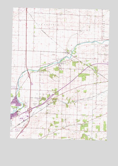
Shopiere, WI USGS Topographic Map
Click on map above to begin viewing in our Map Viewer.

This topographic map contains these locations and features:
Feature Name Type Latitude Longitude GNIS ID View Map
205 ReservoirReservoirN42.5733°W88.9384°1792227View Map
Arndt FarmsLocaleN42.6119°W88.9908°2546798View Map
Arrowhead OrchardsLocaleN42.5519°W88.9319°2516914View Map
Boutelle QuarryMineN42.5344°W88.9500°2633471View Map
Clinton Corners CemeteryCemeteryN42.5537°W88.8922°1563196View Map
Clinton Sewage Treatment PlantLocaleN42.5486°W88.8753°2723896View Map
Dunn QuarryMineN42.5756°W88.8753°2633496View Map
FoxhollowPopulated PlaceN42.5139°W88.9079°1565241View Map
Interchange 183CrossingN42.5603°W88.9771°1834057View Map
Interchange 185CrossingN42.5278°W88.9751°1834058View Map
Morgan Elementary SchoolSchoolN42.5227°W88.9907°1569735View Map
PortersPopulated PlaceN42.5286°W88.9593°1577777View Map
R And S Rolling RanchLocaleN42.5472°W88.9811°2546802View Map
Schuster SchoolSchoolN42.5397°W88.9990°1573824View Map
ShopierePopulated PlaceN42.5725°W88.9384°1574070View Map
Shopiere DamDamN42.5733°W88.9384°1792226View Map
Sweet Allyn Memorial ParkParkN42.5745°W88.9396°1575178View Map
TiffanyPopulated PlaceN42.5825°W88.9271°1575441View Map
Town of TurtleCivilN42.5432°W88.9441°1584301View Map
Turtle AirportAirportN42.5070°W88.9148°1581882View Map
Turtle Fire Department Station 1BuildingN42.5755°W88.9422°2698063View Map
Turtle Town Police DepartmentBuildingN42.5777°W88.9437°2759894View Map
TurtlevillePopulated PlaceN42.5700°W88.9630°2760397View Map
Turtleville CemeteryCemeteryN42.5688°W88.9676°1575731View Map

Note: Coordinates in the location and feature list above are referenced to NAD83 datum.


Copyright (C) 2008-2024 Ryan Niemi / Sunset Dynamics ... All Rights Reserved