TopoQuest Logo
Do you find TopoQuest useful?
Help keep TopoQuest running and adding new maps/features by donating!
Bitcoin:  19c7KJd3qBynnjoSw5npx9KScwjBe4ifkT
Litecoin:  LXs6TkuXGGXo1vDsWCkWVdjQX94eUKd6ui
Home View Maps Find Maps Find Places Resources & Links


Shiprock, New Mexico Topographic Map

USGS Map Title: Shiprock, NM
USGS Map MRC: 36108G6
DRG (GeoTIFF) Download: o36108g6.tif


Neighboring USGS Topographic Map Quads:


  Canal Creek, NM  
36108H7
 

  Skinney Rock, NM  
36108H6
 

  Palmer Mesa, NM  
36108H5
 

  Rattlesnake, NM  
36108G7
 

  Shiprock, NM  
36108G6
 

  Chimney Rock, NM  
36108G5
 

  Ship Rock, NM  
36108F7
 

  Sulphur Spring, NM  
36108F6
 

  The Hogback North, NM  
36108F5


Map MRC Location:

N37°
W109°
N37°
W108°
H8 H7 H6 H5 H4 H3 H2 H1
G8 G7 G6 G5 G4 G3 G2 G1
F8 F7 F6 F5 F4 F3 F2 F1
E8 E7 E6 E5 E4 E3 E2 E1
D8 D7 D6 D5 D4 D3 D2 D1
C8 C7 C6 C5 C4 C3 C2 C1
B8 B7 B6 B5 B4 B3 B2 B1
A8 A7 A6 A5 A4 A3 A2 A1
N36°
W109°
N36°
W108°

Shiprock, NM USGS 1:24K Topographic Map Preview:
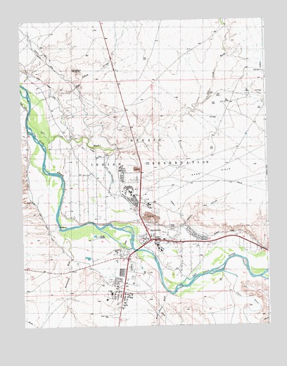
Shiprock, NM USGS Topographic Map
Click on map above to begin viewing in our Map Viewer.

This topographic map contains these locations and features:
Feature Name Type Latitude Longitude GNIS ID View Map
12K-300A Water WellWellN36.7889°W108.6812°927143View Map
12T-520 Water WellWellN36.7764°W108.6945°927139View Map
Baker ArroyoStreamN36.7906°W108.6684°885998View Map
Beclabito ChapelChurchN36.7856°W108.6870°920458View Map
Blanchard MineMineN36.7833°W108.7465°916917View Map
Blue Gap/Four Corners United Methodist ChurchChurchN36.7856°W108.6870°920927View Map
Chaco RiverStreamN36.7769°W108.6537°936834View Map
Ditch Number EightCanalN36.8208°W108.7151°900144View Map
Ditch Number NineCanalN36.8464°W108.7340°900011View Map
Enos Johnson MineMineN36.7847°W108.6831°939844View Map
First Baptist ChurchChurchN36.7856°W108.6870°920486View Map
Hogback Ruin Historic SiteLocaleN36.7856°W108.6870°933399View Map
Many Devils WashStreamN36.7644°W108.6776°885492View Map
Mesa Elementary SchoolSchoolN36.7861°W108.6809°934123View Map
Mesa View Assembly ChurchChurchN36.7856°W108.6870°920475View Map
Natanni Nez Elementary SchoolSchoolN36.7861°W108.6809°934124View Map
Navajo Community CollegeSchoolN36.7856°W108.6870°901634View Map
Navajo Community College LibraryBuildingN36.7856°W108.6870°929331View Map
Navajo Nation Police StationBuildingN36.7865°W108.6847°2722548View Map
Nelson Pit and Shady SideMineN36.7847°W108.6831°916381View Map
Nizhoni Elementary SchoolSchoolN36.7861°W108.6809°934127View Map
Northern Navajo Medical CenterHospitalN36.8052°W108.6917°2697009View Map
Pictured Cliffs Historic SiteLocaleN36.7856°W108.6870°935219View Map
Rattlesnake WashStreamN36.7897°W108.7304°897453View Map
Salt Creek WashStreamN36.8354°W108.7465°201755View Map
San Juan County Fire District 12 ShiprockBuildingN36.7866°W108.6876°2657875View Map
San Juan County Fire District 13 NewcombBuildingN36.7608°W108.7008°2658178View Map
San Juan River Bridge Historic SiteBridgeN36.7856°W108.6870°935203View Map
ShiprockPopulated PlaceN36.7856°W108.6870°902354View Map
Shiprock Alternative Kindergarten SchoolSchoolN36.7861°W108.6809°934055View Map
Shiprock Alternative SchoolSchoolN36.7861°W108.6809°934054View Map
Shiprock CemeteryCemeteryN36.7972°W108.6817°931306View Map
Shiprock Census Designated PlaceCensusN36.7924°W108.7006°2408729View Map
Shiprock Community Health CenterHospitalN36.7856°W108.6870°901318View Map
Shiprock Community Health Center LibraryBuildingN36.7856°W108.6870°929428View Map
Shiprock Northwest High SchoolSchoolN36.8058°W108.6976°934125View Map
Shiprock PitMineN36.7847°W108.6831°916313View Map
Shiprock Post OfficePost OfficeN36.7856°W108.6870°937760View Map
Shiprock United Methodist ChurchChurchN36.7856°W108.6870°919941View Map
Shiprock Weather StationLocaleN36.7856°W108.6870°932207View Map
Tse' Bit' ai Mid SchoolSchoolN36.7861°W108.6809°934126View Map
USIS Water WellWellN36.7825°W108.6907°927141View Map
Yellow ArroyoStreamN36.8425°W108.7406°896811View Map
Yellow ButteSummitN36.8547°W108.7218°902855View Map

Note: Coordinates in the location and feature list above are referenced to NAD83 datum.


Copyright (C) 2008-2024 Ryan Niemi / Sunset Dynamics ... All Rights Reserved