TopoQuest Logo
Do you find TopoQuest useful?
Help keep TopoQuest running and adding new maps/features by donating!
Bitcoin:  19c7KJd3qBynnjoSw5npx9KScwjBe4ifkT
Litecoin:  LXs6TkuXGGXo1vDsWCkWVdjQX94eUKd6ui
Home View Maps Find Maps Find Places Resources & Links


Shining Rock, North Carolina Topographic Map

USGS Map Title: Shining Rock, NC
USGS Map MRC: 35082C7
DRG (GeoTIFF) Download: o35082c7.tif


Neighboring USGS Topographic Map Quads:


  Waynesville, NC  
35082D8
 

  Cruso, NC  
35082D7
 

  Dunsmore Mountain, NC  
35082D6
 

  Sam Knob, NC  
35082C8
 

  Shining Rock, NC  
35082C7
 

  Pisgah Forest, NC  
35082C6
 

  Lake Toxaway, NC  
35082B8
 

  Rosman, NC  
35082B7
 

  Brevard, NC  
35082B6


Map MRC Location:

N36°
W83°
N36°
W82°
H8 H7 H6 H5 H4 H3 H2 H1
G8 G7 G6 G5 G4 G3 G2 G1
F8 F7 F6 F5 F4 F3 F2 F1
E8 E7 E6 E5 E4 E3 E2 E1
D8 D7 D6 D5 D4 D3 D2 D1
C8 C7 C6 C5 C4 C3 C2 C1
B8 B7 B6 B5 B4 B3 B2 B1
A8 A7 A6 A5 A4 A3 A2 A1
N35°
W83°
N35°
W82°

Shining Rock, NC USGS 1:24K Topographic Map Preview:
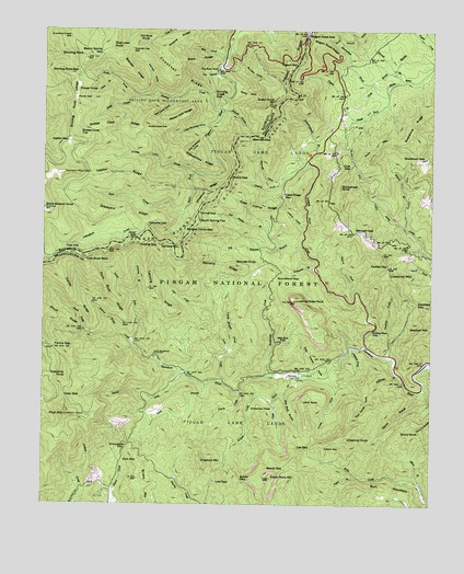
Shining Rock, NC USGS Topographic Map
Click on map above to begin viewing in our Map Viewer.

This topographic map contains these locations and features:
Feature Name Type Latitude Longitude GNIS ID View Map
Art Loeb TrailTrailN35.2784°W82.8662°1018070View Map
Barnett BranchStreamN35.3618°W82.7598°1008938View Map
Bearpen RidgeRidgeN35.3646°W82.8476°1009038View Map
Bearwallow BrookStreamN35.3579°W82.7643°1009048View Map
Beech Spring GapGapN35.3690°W82.8568°1009141View Map
Bell Collar CoveValleyN35.3567°W82.8337°1009160View Map
Bennett BranchStreamN35.3540°W82.8179°1009174View Map
Bennett CoveValleyN35.3358°W82.7985°1009176View Map
Bennett GapGapN35.3221°W82.7743°1009177View Map
Bennett GapGapN35.3471°W82.8082°1009178View Map
Bennett KnobSummitN35.3132°W82.8143°1019091View Map
Big Bearpen BranchStreamN35.3187°W82.7921°1009252View Map
Big Buckeye CoveValleyN35.3465°W82.8232°1009281View Map
Big CoveValleyN35.3679°W82.8164°1009289View Map
Big East ForkPopulated PlaceN35.3643°W82.8201°1019129View Map
Black Balsam KnobSummitN35.3279°W82.8743°1009428View Map
Bobs RidgeRidgeN35.3668°W82.8262°1009523View Map
Bridges Camp GapGapN35.3226°W82.8290°1009597View Map
Brushy MountainSummitN35.2529°W82.8426°1019343View Map
Buckhorn GapGapN35.3421°W82.7515°1009776View Map
Buckhorn ShelterLocaleN35.3423°W82.7512°1018043View Map
Buckwheat KnobSummitN35.3340°W82.7793°1019385View Map
Bullpen CoveValleyN35.3696°W82.8145°1009808View Map
Burl MountainSummitN35.2521°W82.7757°1019418View Map
Butter GapGapN35.2559°W82.8098°1009865View Map
Butter Gap ShelterLocaleN35.2554°W82.8087°1018046View Map
Caney Bottom CreekStreamN35.2898°W82.8154°1010014View Map
Case Camp RidgeRidgeN35.3298°W82.8060°1010083View Map
Case Ridge GapGapN35.3318°W82.7976°1010085View Map
Cat GapGapN35.2648°W82.7890°1010092View Map
Catpen GapGapN35.2657°W82.7846°1010108View Map
Cedar Rock CreekStreamN35.2837°W82.7890°1010134View Map
Cedar Rock MountainSummitN35.2571°W82.8010°1010136View Map
Cherry CoveValleyN35.3357°W82.7978°1010205View Map
Cherry GapGapN35.3365°W82.8149°1010212View Map
Chestnut CreekStreamN35.2918°W82.7748°1010238View Map
Chestnut KnobSummitN35.2673°W82.7768°1019631View Map
Chestnut MountainSummitN35.2612°W82.8235°1019644View Map
Chestnut RidgeRidgeN35.3321°W82.8218°1010263View Map
Chestnut RidgeRidgeN35.3634°W82.8321°1010264View Map
Club GapGapN35.3401°W82.7751°1010339View Map
Coontree CreekStreamN35.2890°W82.7623°1010466View Map
Coontree GapGapN35.3037°W82.7548°1010467View Map
Coontree MountainSummitN35.3107°W82.7643°1019773View Map
Coontree Picnic AreaLocaleN35.2887°W82.7643°1023772View Map
Cove CreekStreamN35.2821°W82.8168°1010501View Map
Cove Creek CampgroundLocaleN35.2882°W82.8162°1018044View Map
Cradle of Forestry in AmericaParkN35.3737°W82.7607°1018067View Map
Cradle of Forestry in America Visitor CenterLocaleN35.3532°W82.7774°1023773View Map
Crawford Creek GapGapN35.3732°W82.8668°1010577View Map
Daniel RidgeRidgeN35.3034°W82.8643°1010647View Map
Daniel Ridge CreekStreamN35.2923°W82.8454°1010648View Map
Daniels CoveValleyN35.3589°W82.8390°1010651View Map
Dark ProngStreamN35.3273°W82.8299°1010657View Map
Deep GapGapN35.2782°W82.8674°1010738View Map
Deep Gap ShelterLocaleN35.2787°W82.8685°1018045View Map
Dina BranchStreamN35.3626°W82.8524°1010823View Map
Dog Loser KnobSummitN35.3704°W82.8537°1019996View Map
Dry BranchStreamN35.3643°W82.8196°1010908View Map
East Horse CoveValleyN35.2790°W82.7714°1010998View Map
Farlow GapGapN35.2909°W82.8712°1011178View Map
Fate Osteen CoveValleyN35.2843°W82.7855°1011185View Map
Fawn BranchStreamN35.2573°W82.7726°1011188View Map
Flower GapGapN35.3571°W82.8646°1011295View Map
Flower KnobSummitN35.3590°W82.8643°1020295View Map
Fork River BaldSummitN35.3143°W82.8612°1020322View Map
Fork River RidgeRidgeN35.3040°W82.8526°1011336View Map
Gloucester GapGapN35.2657°W82.8471°1011540View Map
Grassy Cove GapGapN35.3487°W82.8418°1011627View Map
Grassy Cove RidgeRidgeN35.3484°W82.8501°1011628View Map
Grassy Cove TopSummitN35.3484°W82.8640°1020505View Map
Graveyard RidgeRidgeN35.3273°W82.8499°1011670View Map
Greasy Cove ProngStreamN35.3373°W82.8271°1011682View Map
Green KnobSummitN35.3565°W82.8012°1011702View Map
Grogan CreekStreamN35.2768°W82.8007°1011755View Map
Gumstand BranchStreamN35.3123°W82.7882°1011771View Map
Gumstand GapGapN35.3098°W82.8004°1011772View Map
Henry BranchStreamN35.3232°W82.7585°1011971View Map
Horse CoveValleyN35.2807°W82.7795°1012187View Map
Ivestor GapGapN35.3454°W82.8668°1012379View Map
Ivestor RidgeRidgeN35.3371°W82.8510°1012380View Map
John RockLocaleN35.2837°W82.7940°1012505View Map
John RockSummitN35.2773°W82.7910°1020963View Map
John Rock BranchStreamN35.2796°W82.7965°1012506View Map
John Rock Scenic AreaLocaleN35.2762°W82.7882°1018047View Map
Justus CoveValleyN35.3225°W82.7910°1012590View Map
Lanning BranchStreamN35.3046°W82.8462°1012681View Map
Lanning RidgeRidgeN35.3048°W82.8385°1012682View Map
Laurel ForkStreamN35.2837°W82.8282°1012733View Map
Little Buckeye CoveValleyN35.3496°W82.8221°1012923View Map
Log Hollow BranchStreamN35.3184°W82.7957°1013077View Map
Long BranchStreamN35.2823°W82.8224°1013103View Map
Looking Glass CreekStreamN35.2912°W82.7693°1013188View Map
Looking Glass FallsFallsN35.2965°W82.7679°1013189View Map
Looking Glass RockSummitN35.3037°W82.7935°1013190View Map
Looking Glass Rock Scenic AreaLocaleN35.2990°W82.7873°1023771View Map
Low GapGapN35.2559°W82.8185°1013220View Map
Mine BranchStreamN35.2559°W82.7532°1013605View Map
Moore CoveValleyN35.3066°W82.7742°1013682View Map
Nobreechies RidgeRidgeN35.3398°W82.8257°1013967View Map
North Prong Shining CreekStreamN35.3576°W82.8449°1014021View Map
Oaklog GapGapN35.3187°W82.8385°1014067View Map
Old Butt KnobSummitN35.3718°W82.8432°1021729View Map
Picklesimer FieldsAreaN35.2759°W82.8004°1014380View Map
Pigeon BranchStreamN35.3515°W82.7749°1014385View Map
Pigeon GapGapN35.3657°W82.7940°1014387View Map
Pilot MountainSummitN35.2734°W82.8671°1021902View Map
Pink Bed Picnic AreaLocaleN35.3537°W82.7779°1023774View Map
Pisgah RidgeRidgeN35.3640°W82.7965°1014495View Map
Poundingmill BranchStreamN35.3401°W82.7896°1022065View Map
Raven Cliff RidgeRidgeN35.3518°W82.8315°1014762View Map
Rich MountainSummitN35.2615°W82.8437°1022261View Map
Rich MountainSummitN35.3415°W82.7707°1022263View Map
Right Fork Davidson RiverStreamN35.2923°W82.8454°1014898View Map
Rockhouse CreekStreamN35.2846°W82.8001°1015008View Map
Rocky CoveValleyN35.3590°W82.8136°1015030View Map
Saddle GapGapN35.3134°W82.7640°1015151View Map
Sandy GapGapN35.2593°W82.7968°1015238View Map
Sassafras KnobSummitN35.2834°W82.8674°1022507View Map
Searcy CreekStreamN35.2798°W82.8112°1015343View Map
Second FallsFallsN35.3218°W82.8451°1015345View Map
Seniard MountainSummitN35.3184°W82.8371°1022541View Map
Seniard RidgeRidgeN35.3143°W82.8182°1015355View Map
Shining CreekStreamN35.3543°W82.8187°1015441View Map
Shining Creek GapGapN35.3584°W82.8210°1015442View Map
Shining RockSummitN35.3682°W82.8624°1022609View Map
Shining Rock GapGapN35.3643°W82.8637°1015444View Map
Shining Rock LedgeRidgeN35.3632°W82.8637°1015445View Map
Shining Rock Parking AreaLocaleN35.3651°W82.8187°1018042View Map
Shuck RidgeRidgeN35.3015°W82.8740°1015491View Map
Shuck Ridge CreekStreamN35.2948°W82.8504°1015492View Map
Shut-in BranchStreamN35.2801°W82.7537°1015504View Map
Slick Rock FallsFallsN35.2932°W82.7973°1015583View Map
Sliding Rock Recreation SiteLocaleN35.3137°W82.7874°1023775View Map
Soapstone RidgeRidgeN35.3534°W82.7512°1015664View Map
South Prong Shining CreekStreamN35.3576°W82.8449°1015710View Map
South Spring TopSummitN35.3251°W82.8249°1022717View Map
Spanish Oak GapGapN35.3701°W82.8462°1015720View Map
Stillwater BranchStreamN35.2840°W82.7593°1015850View Map
Stony KnobSummitN35.2701°W82.7562°1022808View Map
Tennent MountainSummitN35.3371°W82.8690°1022905View Map
The Pink BedsFlatN35.3679°W82.7585°1016095View Map
Township of BrevardCivilN35.2814°W82.7690°1027229View Map
Tunnel GapGapN35.3268°W82.8254°1016260View Map
Upper FallsFallsN35.3182°W82.8674°1016336View Map
Wagon Road GapGapN35.3737°W82.7907°1016388View Map
Wagon Road RidgeRidgeN35.3709°W82.7851°1016389View Map
Yellowstone FallsFallsN35.3237°W82.8410°1016873View Map
Yellowstone ProngStreamN35.3271°W82.8299°1016874View Map

Note: Coordinates in the location and feature list above are referenced to NAD83 datum.


Copyright (C) 2008-2024 Ryan Niemi / Sunset Dynamics ... All Rights Reserved